Prioritize...
When you've finished this section, you should be able to discuss classification schemes for tropical cyclones, including associating the proper criteria and thresholds for the terms hurricane, tropical storm, tropical depression, typhoon, and super typhoon. You should also able to describe the Saffir-Simpson scale and define the term subtropical cyclone.
Read...
Although I imagine most everyone is familiar with the term "hurricane", before we study the nuts and bolts of these storms, we've got to cover some terminology that helps scientists (and the public) classify tropical cyclones. After all, not all tropical cyclones are hurricanes! For starters, formally, a tropical cyclone is the generic name given to low-pressure systems that form over warm tropical or subtropical seas.
As I mentioned previously, tropical cyclones are meteorologically different than the mid-latitude cyclones (also called "extratropical cyclones") that you learned about earlier. For starters, tropical cyclones have a "warm core," meaning that temperatures throughout most of the troposphere are higher at the center of a tropical cyclone compared to its surroundings. Mid-latitude cyclones, on the other hand, are "cold core." Another big difference is that mid-latitude cyclones rely on the presence of large temperature gradients to strengthen (mid-latitude cyclones are associated with fronts). Tropical cyclones, conversely, usually form in environments with small temperature gradients (in other words, environments without fronts).
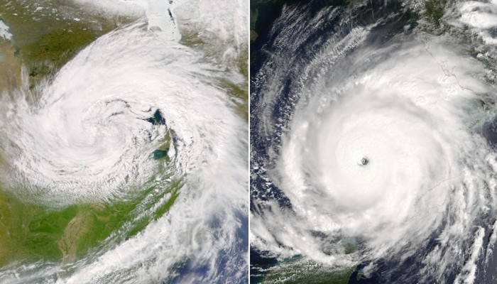
Instead of relying on large temperature gradients, organized thunderstorms around the center of a tropical cyclone are key to its livelihood (for reasons we'll investigate later in the lesson). Mid-latitude cyclones, on the other hand, often have thunderstorms well displaced from their centers (if they have any thunderstorms associated with them at all). This difference leads well-developed tropical cyclones and mid-latitude cyclones to appear very differently on satellite imagery. For example, check out this color-enhanced water vapor loop from July 9, 2018. The loop shows two cyclones marked by distinct counterclockwise swirls. The cyclone closer to the U.S. coast a tropical cyclone (Tropical Storm Chris), which has lots of tall, thunderstorm clouds near its center. The cyclone farther northeast is a mid-latitude cyclone, which lacks thunderstorms near its center. The side-by-side visible satellite images below also highlight the visual contrasts between tropical and mid-latitude cyclones. On the left, a large mid-latitude cyclone centered near Lake Michigan demonstrated a familiar comma shape on May 11, 2003, thanks to the conveyor-belts and fronts that you learned about previously. On the right, however, Hurricane Rita lacks the comma shape of a mid-latitude cyclone, and has thick, tall thunderstorm clouds surrounding its center.
The visual differences between mid-latitude and tropical cyclones provide a clue that they operate a bit differently, and we'll see how as the lesson unfolds. But, first, let's break down the types of tropical cyclones to see how meteorologists classify and keep track of them. For starters, forecasters often have their eyes on clusters of showers and thunderstorms across the tropics (often called "tropical disturbances"). Tropical disturbances do not have closed circulations and are not formally tropical cyclones; however, by convention in the U.S., tropical disturbances that have the potential to develop into tropical cyclones are dubbed "invests." But, if a tropical disturbance with organized thunderstorms develops a closed circulation around its surface center of low pressure (counterclockwise in the Northern Hemisphere; clockwise in the Southern Hemisphere), a tropical cyclone is born! Meteorologists then use the following labels to classify the cyclone:
- Tropical Depression: a tropical cyclone with maximum sustained wind speeds less than 34 knots (39 miles per hour). "Sustained" is a key word there because definitions of what a "sustained" wind is vary across the globe (it could mean anywhere from a 1-minute average wind speed to a 10-minute average wind speed). So, classifications of tropical cyclones can vary across the globe based on different definitions of "sustained." Also note that to be classified as a tropical depression, a tropical disturbance must develop a closed surface circulation, organized thunderstorms, and wind speeds less than 34 knots (39 miles per hour).
- Tropical Storm: a tropical cyclone with maximum sustained wind speeds of at least 34 knots (39 miles per hour). When a tropical storm is identified, it formally receives a name (we'll talk more about naming conventions later in the lesson). Tropical cyclones retain their tropical storm status as long as their maximum sustained winds remain between 34 knots and 63 knots.
- Hurricane: a tropical cyclone with maximum sustained winds of at least 64 knots (74 miles per hour).
Typically, a developing tropical cyclone will evolve from a tropical depression to a tropical storm before becoming a hurricane (if conditions are favorable for strengthening). It's important to note that tropical cyclones are classified by their maximum sustained wind speed (an average wind over a length of time ranging from 1 to 10 minutes, depending on the region of the globe). They are not classified by maximum wind gusts (short bursts of wind lasting a few seconds). The most intense tropical cyclones are called hurricanes, but they only go by that name in some parts of the world (including the United States). Indeed, in other parts of the world, tropical cyclones go by other names. For example, in the Northwest Pacific Ocean, forecasters use the word typhoon instead of hurricane. In parts of the Indian Ocean, such storms are called "severe cyclonic storms," while in other parts of the Indian Ocean, they're called "severe tropical cyclones." So, don't be confused when you hear a terms like typhoon, severe cyclonic storm, or severe tropical cyclone. They all describe storms that are the same as hurricanes (tropical cyclones with maximum sustained winds of at least 64 knots).
At times, I may generically refer to "hurricanes," but keep in mind that such references also include strong tropical cyclones that go by various labels in ocean basins around the world. Of course, all "strong" tropical cyclones (hurricanes, typhoons, etc.) are not created equal. Some are much more intense than others. In the Atlantic and Northeast Pacific basins, forecasters use the Saffir-Simpson Hurricane Wind Scale to further classify a given hurricane. Hurricanes classified as Category 3, Category 4, or Category 5 (all hurricanes with maximum sustained winds of at least 96 knots, or 111 mph) qualify as major hurricanes.
| Category | Maximum Sustained Wind | Description |
|---|---|---|
| 1 | 64-82 knots (74-95 mph) | Minor wind damage (to roofs, shingles, siding, gutters, large tree branches, etc.). Damage to power lines and poles may result in power outages that could last several days. |
| 2 | 83-95 knots (96-110 mph) | Extensive wind damage (major roof and siding damage, shallow-rooted trees snapped or uprooted). Power outages may last several days to weeks. |
| 3 | 96-112 knots (111-129 mph) | Devastating wind damage (major damage to, or complete loss of roofs, many trees snapped or uprooted). Electricity and water likely unavailable for several days to weeks. |
| 4 | 113-136 knots (130-156 mph) | Catastrophic wind damage (complete loss of roofs and major damage to exterior walls of some homes, most trees snapped or uprooted and power poles downed). Power outages may last weeks or months, making hardest-hit areas uninhabitable. |
| 5 | 137+ knots (157+ mph) | Catastrophic wind damage (a high percentage of framed homes destroyed, residential areas isolated by fallen trees and power poles). Power outages will last for weeks or months, making hardest-hit areas uninhabitable. |
Although major hurricanes make up only 21 percent of the hurricanes that hit the United States, these fierce storms account for over 83 percent of all the damage from landfalling hurricanes. Other ocean basins also have different descriptors for extremely intense tropical cyclones. In the Northwest Pacific Basin, for example, the particularly descriptive classification of "super typhoon" is used once a typhoon's maximum sustained wind speed reaches at least 130 knots (more than twice the minimum wind-speed criteria for a typhoon). Super typhoons are the equivalent of a at least a high-end Category 4 hurricane on the Saffir-Simpson Scale.
Like the basic classification scheme for tropical cyclones (tropical depression, tropical storm, hurricane), the categories of the Saffir-Simpson Scale and other descriptors like "major hurricane" and "super typhoon" are all based on the maximum sustained wind speed within the storm. These winds are usually confined to a relatively small area of the storm somewhere near the center, so the types of wind damage described by, say, a Category 3 hurricane on the Saffir-Simpson Scale, typically occur only in areas that take a "direct hit" from the storm (the center passes nearby). Areas farther from the center may also experience wind damage, but it's typically less severe than what's described by the storm's Saffir-Simpson rating. Winds, however, are only one hazard posed by tropical cyclones. Indeed, a tropical cyclone need not even reach hurricane status to cause devastating effects (flooding in southeast Texas from Tropical Storm Allison in 2001 is a prime example). So, just because a tropical cyclone doesn't have strong enough winds to be a hurricane doesn't mean it can't be catastrophic!
You also may have heard of another storm classification, called a subtropical cyclone, which is a "hybrid storm" of sorts. A subtropical cyclone has characteristics of both tropical cyclones and mid-latitude cyclones, meaning that it may have a warm core through a small part of the troposphere only while being embedded in a region of large temperature gradients. So, you may hear meteorologists use the terms "subtropical depression" or "subtropical storm" to describe these hybrids. Such classifications help meteorologists diagnose a storm's structure and keep historical records, but most people might not notice a difference in impacts between, say, a subtropical depression and a tropical depression (their weather impacts would be similar). In case you're wondering, subtropical cyclones can transition into tropical cyclones if they can fully develop a warm core and organized thunderstorms around their center, and exit regions of large temperature gradients.
Now that we've covered some basic terms and classifications, we're going to talk about the climatology of tropical cyclones. In particular, we'll focus on where, when, and why they tend to form around the world. Read on.