Prioritize...
After completing this section, you should be able to describe the process by which a tropical cyclone intensifies, including the air flow through a tropical cyclone (known as the "secondary circulation"). You should also be able to describe why tropical cyclones weaken over land, and define "stadium effect."
Read...
Over the past couple of sections, we've covered the ingredients needed for tropical cyclones to form and thrive. Here they are again, as a reminder:
Tropical Cyclone Ingredients
The six basic ingredients for tropical cyclone formation are:
- Sea-surface temperatures of at least 26.5 degrees Celsius or 80 degrees Fahrenheit (usually). A deep warm layer of water beneath the ocean surface (of at least 50 meters or so) can be helpful, but is not necessarily required.
- A location (usually) at least five degrees of latitude (roughly 300 nautical miles) away from the equator.
- A pre-existing disturbance (cluster of showers and thunderstorms) with favorable low-level spin and convergence in the lower half of the troposphere.
- Low values of vertical wind shear between roughly 5,000 and 38,000 feet (generally less than 10 meters per second, or 20 knots).
- A middle troposphere (roughly from about 10,000 to 20,000 feet) that is relatively moist (has moderate to high relative humidity).
- A troposphere that is neutrally stable or unstable with respect to rising moist air parcels (environmental lapse rates must not be too stable such that thunderstorm development is greatly inhibited).
So, what exactly happens when all of these ingredients get mixed together and the atmosphere cooks up a storm? In other words, how does a tropical cyclone go from a rather disorganized cluster of thunderstorms (like in the enhanced infrared image on the left below), to a highly organized, powerful hurricane (like in the image on the right below)?
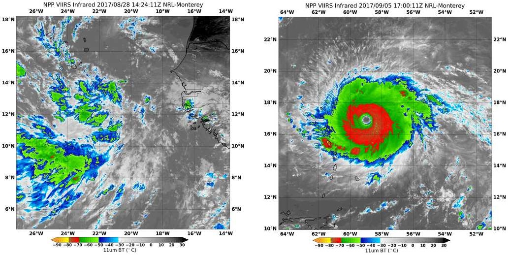
The image above on the left shows the tropical disturbance -- a somewhat disorganized area of showers and thunderstorms -- that would eventually develop into Hurricane Irma, as seen on enhanced infrared imagery on August 28, 2017. A week later (above on the right), Irma had developed into a well-organized, powerful Category 5 hurricane with a distinctive eye. How did Irma go from a cluster of showers and thunderstorms to a monster hurricane?
Well, for starters, the six ingredients listed above all were obviously present in a favorable fashion. But, let's explore how a tropical cyclone actually strengthens. I'll cover the process as a series of steps, and you'll see that the idea of feedback is very important. Assuming we're starting with a tropical disturbance over sufficiently warm water, far enough from the equator in a neutrally stable or unstable environment...
- as low-level air converges into the region of thunderstorms, it flows over the warm ocean, which increases evaporation from the water below (spray from turbulent waves evaporates, etc.) and moistens the low-level air.
- In this way, the interaction between the atmosphere and ocean actually makes the environment more favorable for thunderstorms within the developing tropical cyclone by creating and sustaining an area where the low-level air is locally more moist than its surroundings. As air rises in thunderstorm updrafts near the center of the storm, it cools, but releases latent heat along the way. The release of latent heat makes the air near the core of the storm warmer than its surroundings.
- As air parcels reach the tops of thunderstorms at the tropopause, most flow outward, creating upper-level divergence which reduces the weight of central air columns and reduces surface pressure. Some lofty air parcels also sink into the center and warm. This warming also works to reduce surface pressure because these warmer air columns are less dense than their surroundings.
- Lower surface pressures at the center of the storm work to increase the pressure gradient across the storm, which increases surface wind speeds. Faster winds blowing over the ocean further increases evaporation rates of warm ocean waters (further moistening the low-level air toward the center of the storm), which favors more thunderstorms, and so on.
- If thunderstorms can remain organized and flourish around the center of the storm for long enough, the sinking, warming air over the center of the storm evaporates clouds and the eye forms, signifying a healthy tropical cyclone. Surface pressures continue to fall as upper-level divergence and warming from sinking air over the center continue.
To help you visualize this process, check out the short video (2:37) I created below, which shows a cross-section through a hurricane, and highlights way air parcels flow through a tropical cyclone, helping it to strengthen. Keep in mind that in reality, air spirals inward toward the center of a tropical cyclone in the lower troposphere (remember, air flows counterclockwise around low-pressure systems in the Northern Hemisphere), but the schematic shown in the video shows a simpler picture and emphasizes the storm's "secondary circulation," tracing air parcels as they flow in toward the center of the storm at low altitudes, then rise in thunderstorms, and then flow outward at the top of the storm (they ultimately sink around the periphery of the tropical cyclone).
To see how a hurricane intensifies, we're going to look at a cross-section of a developing hurricane and follow the paths of air parcels through the storm. In reality, air parcels spiral inward toward the center of low pressure at the surface as a hurricane swirls along, but we're not going to worry about the storm's rotation, and instead we're going to focus on the secondary circulation to see how tropical cyclones intensify.
To start, we'll assume that we have a minimal hurricane with a minimum central pressure of 985 millibars. Air flows toward the center of low pressure at the surface, and on its path in toward the center of the storm, evaporation of warm ocean water moistens the low-level air, making it more favorable to rise in thunderstorm clouds in the eye wall. Air parcels rise in tall thunderstorms in the eye wall, and most of the air parcels flow outward at the top of the storm, creating upper-level divergence that acts to reduce surface pressure by reducing the weight of air columns near the center of the storm. But, some air parcels sink into the eye and they warm up as they sink. This warming also helps reduce surface pressure because warmer air columns over the center of the storm are less dense.
As the surface pressure drops, now at 966 millibars in our example, the pressure gradient across the storm increases, which causes wind speeds to increase. So, low-level air rushes in toward the center of the storm even faster. Faster moving air over the warm ocean water increases evaporation rates, which fuels more intense thunderstorms in the eye wall. More air then flows outward at the top of the storm, creating stronger upper-level divergence, while sinking air in the eye increases too, causing surface pressure to decline even more.
Our example hurricane here now has a central pressure that has dropped to 949 millibars, and we have a really formidable hurricane now. An extremely strong pressure gradient causes air to race in toward the center of the storm at an even faster rate, and high evaporation rates and strong-low level convergence cause eye wall thunderstorms to continue to intensify. The greater upward transport of air in the eye wall leads to more air sinking into the eye and warming, which maximizes the storm's warm core, and also leads to stronger upper-level divergence, both of which favor additional declines in surface pressure.
This feedback loop can continue if a hurricane remains in an environment with favorable ingredients, but if one or more of the ingredients for tropical cyclones becomes unfavorable, thunderstorms near the center either weaken or become disrupted, which ultimately leads to increasing surface pressure and a weakening tropical cyclone.
This basic sketch of how tropical cyclones strengthen should emphasize the importance of evaporation of warm ocean waters feeding organized thunderstorms around the center of the storm. The upper-level divergence that occurs at the top of these thunderstorms as air spreads out, along with the sinking, warming air over the center of the storm act to reduce surface pressures, intensifying the storm as feedback processes support the development of more thunderstorms. But, if the storm moves into an environment where one or more of the ingredients are unfavorable (say, vertical wind shear is strong, the middle troposphere has low relative humidity, or sea-surface temperatures are less than 80 degrees Fahrenheit), then the thunderstorms become less intense and / or less organized, which interferes with the feedback processes needed to strengthen the storm. In such cases, tropical cyclones typically weaken.
The fact that tropical cyclones rely on evaporation of warm ocean waters to fuel thunderstorms also helps explain why they typically weaken when they travel over land. Without the high evaporation rates offered by warm ocean water, thunderstorm activity inevitably weakens, and the feedback processes break down. Interestingly, some weaker tropical cyclones (tropical depressions and tropical storms, in particular) can actually sustain themselves for a time over land if they travel over a warm area with extremely wet soils (called the "Brown Ocean Effect"). Still, eventually these storms fizzle out over land, too.
But, if favorable ingredients come together for long periods of time over the ocean, the atmosphere can cook up some monster tropical cyclones. For example, check out this 10-day enhanced infrared satellite time-lapse showing the development and intensification of Hurricane Irma from September 1 through September 10, 2017, as it raged through the Caribbean, Cuba, and eventually the United States. At its peak, Irma was a Category 5 hurricane with maximum sustained winds of 180 miles per hour. The time-lapse also shows Hurricane Jose developing right on Irma's heels. Jose peaked briefly as a Category 4 storm, but couldn't maintain that intensity for long because of less favorable environmental conditions.
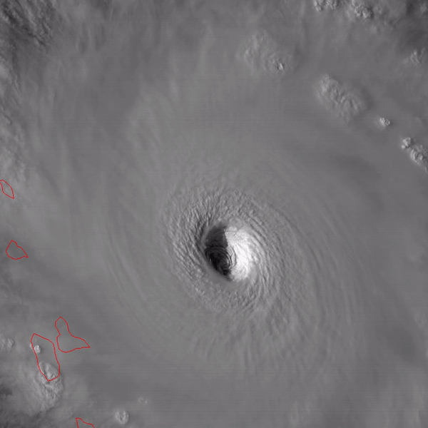
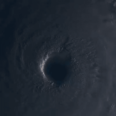
When tropical cyclones become very powerful, they can make for some visually stunning satellite imagery (to meteorologists, anyway). Occasionally, the eye of a powerful tropical cyclone actually takes on the shape of a stadium (credit: Steve Seman) in that it's wider at the top than at the bottom. This so-called stadium effect often signifies an extremely intense tropical cyclone. You can get a sense of the stadium effect from the zoomed-in loop of Hurricane Irma's eye (on the right) from the evening of September 5, 2017. The shadows cast on the eye from the tall clouds surrounding it created a remarkable effect as the sun was setting. The eye of Super Typhoon Lan (2017) gives another good example of the stadium effect.
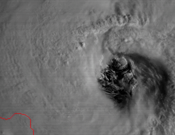
The complex and turbulent processes around the eye of tropical cyclones are on full display in this loop of visible satellite images of Hurricane Maria's eye (credit: NASA / Dakota Smith) from September 21, 2017. Note the chaotic and turbulent motions going on around the eye of the storm in the eye wall. For what it's worth, these small-scale, turbulent processes in tall eye-wall thunderstorms may hold the keys to some aspects of tropical cyclone intensification that aren't yet well understood. Ultimately, the processes described earlier in this section give a good basic idea of how tropical cyclones intensify, but they can't fully explain the very rapid intensification that some tropical cyclones exhibit. Such rapidly intensifying storms pose huge challenges for forecasters, and recent research suggests the turbulent processes in eye-wall thunderstorms may hold the keys to explaining rapid intensification. Research is ongoing, and hopefully will lead to forecasting improvements.
While meteorologists are often in awe of powerful tropical cyclones, these storms are also very dangerous, and public safety relies on accurate forecasts. How do forecasters know whether tropical cyclones are headed for a particular town? We'll answer that question next!