Prioritize...
From this page, you should be able to describe strengths and limitations of the Saffir-Simpson Scale, and be able to discuss why the Saffir-Simpson Scale is sometimes not an adequate descriptor of a hurricane's destructive potential.
Read...
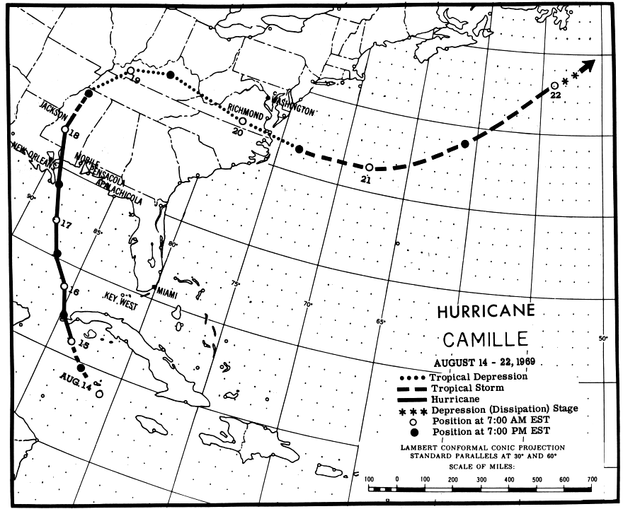
Of all the landfalling hurricanes in U.S. history, Hurricane Camille (1969) holds legendary status. Camille was a Category-5 storm on the Saffir-Simpson Scale that slammed into the central Gulf Coast near the mouth of the Mississippi River around midnight on August 18 with a monstrous storm surge, and was one of only a handful of landfalling hurricanes in the United States to have wind gusts at or above 190 miles per hour.
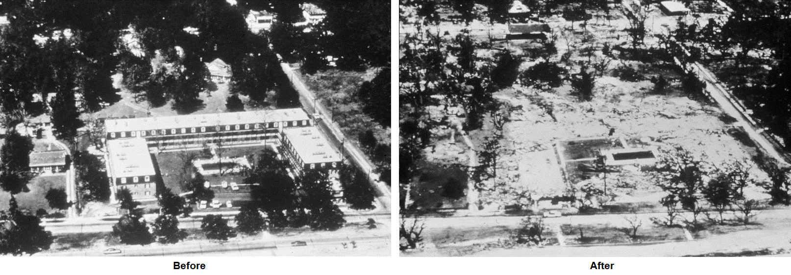
Camille's storm surge was accentuated by the fact that much of the Gulf Coast is quite vulnerable to larger storm surges because of the characteristics of the sea floor near the coast. Indeed, Camille's storm surge exceeded 30 feet along the Mississippi Coast, and flattened everything in its path (these infamous before and after photographs of the Richelieu Apartments in Pass Christian, Mississippi tell the story).
Yet, despite Camille's impressive meteorological statistics (it's one of only a few Category-5 storms to make landfall in the U.S.) and devastation along its path, Camille is not even in the top-10 most destructive hurricanes in U.S. history. Why? By most standards, Camille was a small, compact hurricane. The reanalysis of the wind field around Hurricane Camille at 0430Z on August 18, 1969 (below) indicates that hurricane-force winds were confined to less than 60 nautical miles (about 69 miles) from the storm's center in all directions. In other words, Camille was a violent, but tiny hurricane. The hardest hit areas in the eye wall and nearby were decimated, but that area was relatively small.
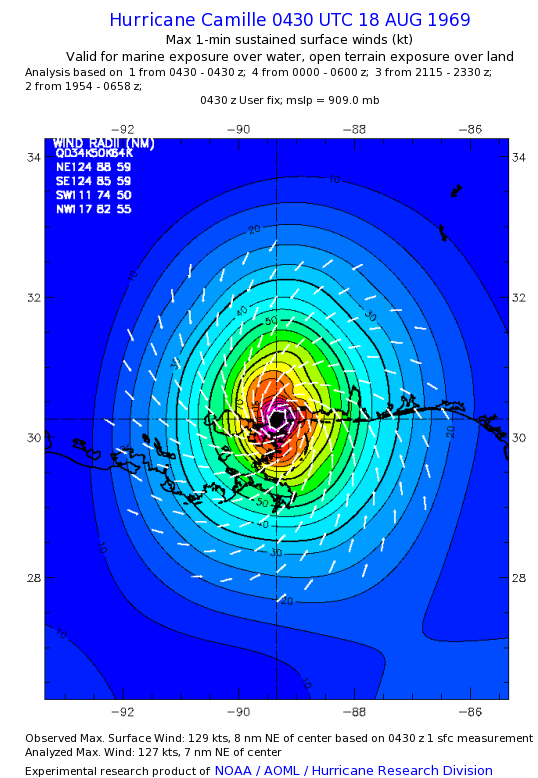
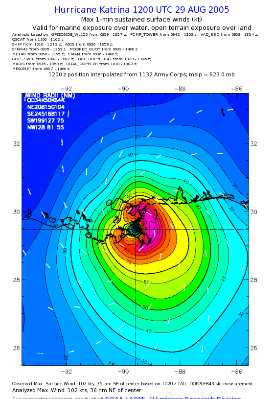
Compare Camille's compact wind structure to the landfalling Hurricane Katrina at 12Z on August 29, 2005, which had hurricane-force winds extending out to 117 nautical miles (about 135 miles) in the storm's southeast quadrant. While Katrina's maximum sustained winds were less than Camille's, Katrina was a larger, much more destructive storm, killing more than 1,500 people in Louisiana and Mississippi and inflicting 106 billion dollars in damage (adjusted for inflation to 2010). By comparison, Camille killed 259 people and caused 9.3 billion dollars in damage (adjusted for inflation to 2010).
So, Hurricane Katrina (a Category-3 storm at landfall) was more than ten times as costly compared to Hurricane Camille (a Category-5 storm), and was responsible for many more deaths. Granted, to a large extent, the number of people killed by tropical cyclones depends on the population of the area in the vicinity of landfall as well as the risk perceived by coastal residents (whether or not they choose to evacuate). Indeed, Katrina was rated as a Category-3 storm as it approached the central Gulf Coast, and there were likely coastal residents who did not evacuate because they didn't perceive Katrina to be as great a threat as a Category-5 storm like Camille. Despite its Category-3 rating, Katrina remains one of the most devastating natural disasters to ever occur in the United States. So, did Katrina's Category-3 rating adequately convey the dangers of the storm to the public?
Evidence shows that a tropical cyclone's maximum sustained wind speed and Saffir-Simpson Scale rating are not necessarily reliable indicators of the destructive potential of the landfalling storm. Moreover, it's pretty clear that the size of the storm really matters in the overall damage inflicted by a landfalling tropical cyclone. Indeed, while the Saffir-Simpson Scale is the "standard" way that hurricanes are rated and their threats communicated to the public, it's pretty clear that the scale has some shortcomings. To better understand these shortcomings, we have to briefly discuss a little about the history of the scale.
Shortcomings of the Saffir-Simpson Scale
As it turns out, the Saffir-Simpson Scale originally included guidelines for more than just the maximum sustained winds in a hurricane. In 1969, a civil engineer, Herbert Saffir, who was inspired by the Richter earthquake magnitude scale, created a hurricane scale designed to indicate hurricane intensity and the damage potential associated with a tropical cyclone. Robert Simpson, then the acting director of the National Hurricane Center, also incorporated storm-surge data in order to indicate the potential for flooding. In the most basic sense, the Saffir-Simpson Scale originally attempted to cover the bases for emergency hurricane response for damage based on winds and surge flooding, although the scale never accounted for potential flooding from heavy rain.
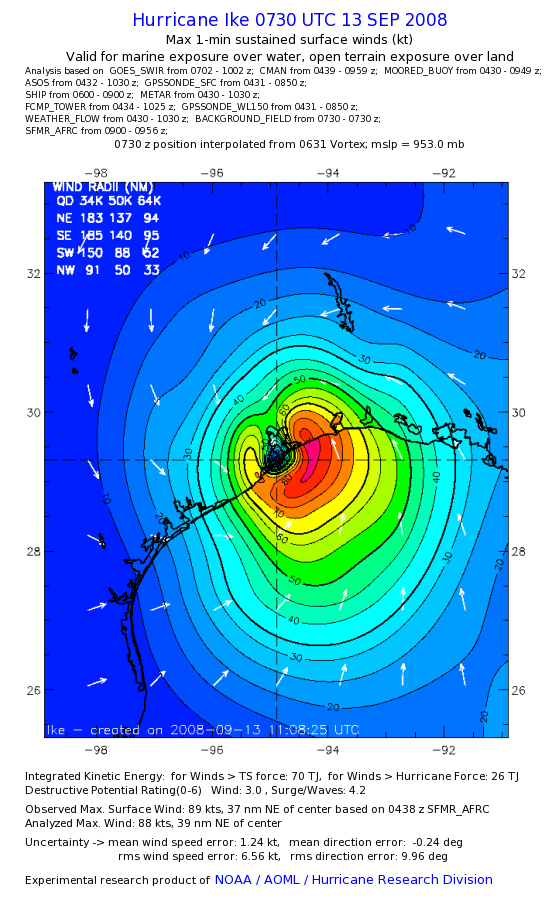
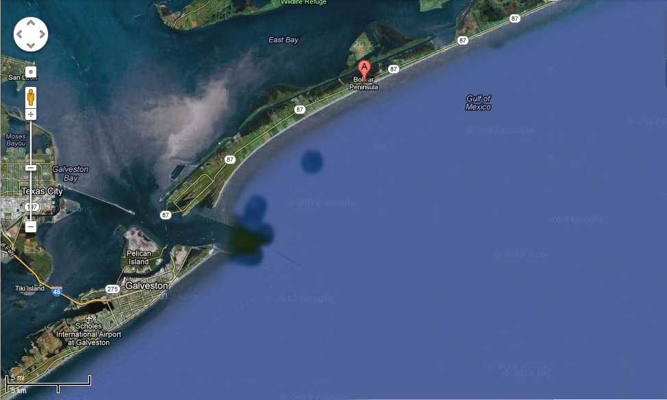
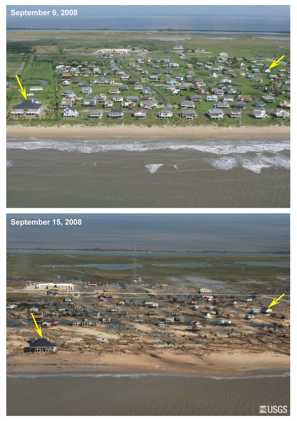
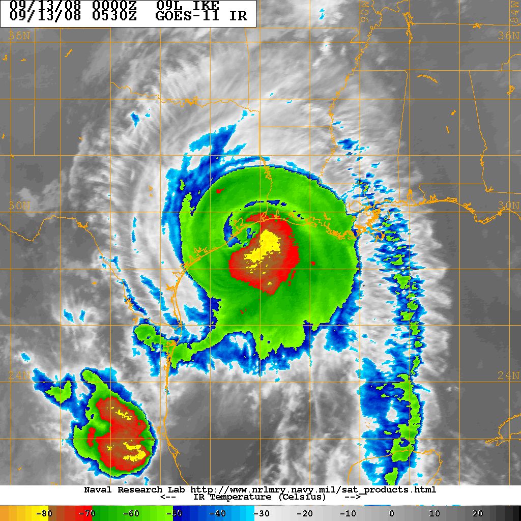
But, Hurricane Katrina's nearly 30-feet of surge into Mississippi was more than twice that indicated for a Category-3 storm in the Saffir-Simpson Scale (and was on par with the surge from Camile, a Category-5 hurricane). Just three years later in 2008, history repeated itself with Hurricane Ike (see the infrared satellite image near landfall below). Like Katrina, Ike was a large storm. The surface wind analysis at 0730Z on September 13, 2008 indicated that the radius of Ike's hurricane-force winds extended out nearly 100 miles in both eastern quadrants near landfall. But, with maximum sustained winds around 89 knots, Ike only qualified as a Category-2 storm on the Saffir-Simpson Scale. Still, Ike created a storm surge of up to 17 feet on the Bolivar Peninsula near Galveston, Texas, which greatly exceeded the storm-surge guidance included in the Saffir-Simpson Scale for a Category-2 storm. Accordingly, damage from Ike along the Bolivar Peninsula was immense, as these before and after photographs (credit: USGS) indicate.
After the storm surges and resulting damage from Ike and Katrina failed to remotely align with the storm surge guidelines in the Saffir-Simpson Scale, the National Hurricane Center formally decided to drop storm surge potential from the scale in 2009, making it the purely wind-based scale we have today. So, the Saffir-Simpson scale rating of a storm really tells us nothing about its damage potential from storm surge (a big limitation). Another issue is the public perception of Saffir-Simpson categories and their impacts. A reduction of one mile per hour below the threshold of a Category-4 storm, for example, would cause the storm to be downgraded to a Category-3 hurricane. The perception might be that the "weakened" storm poses less of a threat (because it's "only" a Category 3), when in reality, the risk remains just as great. Yes, forecasters try to compensate by using expressions such as a "strong Category-3 hurricane," but there's a lot of room for misinterpretation by the general public.
So, it's pretty clear that a particular hurricane's destructive potential includes much more than the Saffir-Simpson Scale rating alone can convey. In the last couple of decades, it's become clear that when it comes to hurricane damage, size does matter! Wind damage depends on the kinetic energy of the moving air, which means that it depends on the wind speed squared. The consequence is that larger hurricanes with larger wind fields pack a lot more wind energy, which leads to more severe damage over a larger area. Furthermore, hurricanes with larger wind fields can push more ocean water onshore, worsening storm surge damage.
With these ideas in mind, researchers have developed several scales and indices to more comprehensively convey a hurricane's destructive potential, but none of them have really caught on with the general public. One calculation to assess a hurricane's damage potential is called Integrated Kinetic Energy (IKE), which essentially uses the surface wind field to add together the kinetic energy of tiny pieces of the storm into total value (the "Integrated Kinetic Energy"). Of course, by adding up all the kinetic energy over the storm's domain, a proxy for storm size is built into the calculation (all else being equal, a larger storm will have more IKE).
On the plot below, compare the IKE for Hurricane Katrina at landfall in Louisiana (seventh storm from the right) with Hurricanes Andrew and Camille (fourth and sixth storms from the left). Both of these Category-5 hurricanes had much lower IKE values than Katrina at landfall in Louisiana because they were much smaller storms. How would the public have judged the risks from Katrina differently if they knew that its damage potential was significantly higher than past Category-5 storms like Camille and Andrew?
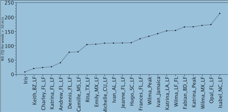
Ultimately, IKE gives a better indication of a storm's damage potential, especially from storm surge, since the size and intensity of the wind field are both included in the calculation. While there's some debate among meteorologists about the best ways to communicate the damage potential from any given storm to the general public (IKE and other alternative damage potential scales haven't caught on), in the meantime, the Saffir-Simpson Scale likely isn't going anywhere because of its simplicity and the public's familiarity with it. However, it's pretty clear that for large tropical cyclones, the Saffir-Simpson rating might not accurately convey the potential for wind and surge damage. Keep that in mind if a hurricane is approaching your area.
Summary
- The Saffir-Simpson Scale only depends on the maximum sustained wind speed in a hurricane (usually in a small area within the eye wall). It provides no information about the size of the storm, about potential damage from storm surge, or about potential for flooding from heavy rain.
- All else being equal, larger hurricanes generally have greater damage potential because their larger wind fields pack much more energy and can help create greater storm surge. Thus, Saffir-Simpson Scale ratings for particularly large hurricanes often don't convey the true damage potential.
- The hard cut-offs of the Saffir-Simpson Scale categories can be misinterpreted by the public (in reality there's very little difference between a "strong Category-3 hurricane" and a hurricane that barely meets the Category 4 wind-speed threshold, for example).
- Alternative metrics (like Integrated Kinetic Energy), which include storm size and total energy from the storm's wind field, better assess the true damage potential from the winds and storm surge of a tropical cyclone, but the public is not very familiar with them.
If you live in a hurricane-prone area, or ever find yourself facing the prospects of dealing with a landfalling tropical cyclone, I urge you to pay close attention to the weather forecast (not just from your weather app), and follow the directives of local authorities any time a tropical cyclone threatens. If a mandatory evacuation is issued for your area, it's for a good reason. By staying, you're putting your own life at great risk, as well as the lives of any first responders who may have to rescue you. If you're looking for more information about tropical cyclones that may impact the Americas, the National Hurricane Center website is a good resource, where you can get forecasts and read discussions written by forecasters at the National Hurricane Center (for some "behind the scenes" thoughts). I hope this lesson helps you better understand tropical cyclones, how they work, and how to stay safe should one affect your area.