Prioritize...
At the end of this page, you should be able to explain the meaning of the terms unstable equilibrium, stable equilibrium, and neutrally stable with respect to parcels of air. You should also be able to compare the cooling rates of rising "dry" and "moist" air parcels to describe why "moist" air parcels have a better chance to remain positively buoyant.
Read...
So far, we've established the idea that the atmosphere is usually close to hydrostatic equilibrium over large areas, which results in vertical accelerations and vertical velocities that are quite small. But, that's not always the case over smaller areas. The strongest thunderstorm updrafts can be near 100 miles per hour, and air parcels need positive buoyancy to achieve such impressive speeds.
If you've listened to meteorologists when thunderstorms were in the forecast, you may have heard them make reference to the stability of the atmosphere. They may have described it as "stable" or "unstable," but what do those terms really mean? Well, in short, they help weather forecasters describe the behavior of air parcels that get slightly displaced from their initial positions. Whether an air parcel will continue in the direction it was displaced or return to its initial position depends on stability.
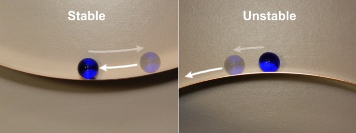
Stability is always discussed in the context of a system in equilibrium (remember that the term equilibrium means that everything is in balance). To help you visualize these concepts, think about a marble sitting in the bottom of a bowl. This marble is in equilibrium: It will sit in the bottom of the bowl forever if nothing disturbs it. Now let's say that you drag the marble up the side of the bowl with your finger. This is not an equilibrium state because as soon as you remove your finger, the marble will begin to move. Although it may roll around a bit, it will settle again at the bottom of the bowl. This is an example of a stable system. In a stable system, small disturbances to the equilibrium always result in a return to that initial state.
Now consider turning the bowl upside down and balancing the marble exactly at its apex. This is also an equilibrium state (the marble will stay there forever if not disturbed). If you displace the marble slightly and let go, what happens now? In this case, the marble does not return to its initial position. It rolls down the side of the bowl onto the table (and perhaps onto the floor and under the refrigerator). It eventually finds a new equilibrium position, often far different from its original state. This is the definition of an unstable system. In an unstable system, small disturbances of the initial equilibrium always result in a new (and perhaps very different) equilibrium state.
We can apply a similar stability test to air parcels that are initially in equilibrium with their environment. By equilibrium, I mean that the temperature (density) of the air inside a stationary parcel is the same as its environment. What happens if our parcel gets a little push upward? Technically, parcels above the ground could get an initial push upward or downward, but we'll focus on upward pushes because they're more relevant to thunderstorm formation. Essentially, one of three scenarios could occur after the parcel is nudged upward:
- the parcel could find itself colder (more dense) than its surroundings, and sink back to its initial position because of negative buoyancy. The layer of the atmosphere where the test occurred is stable in this case.
- the parcel could find itself warmer (less dense) than its surroundings, and accelerate upward away from its initial position because of positive buoyancy. The layer of the atmosphere where the test occurred is unstable in this case.
- the parcel's temperature could be equal to its surroundings (meaning equal density), and the parcel could simply remain in its new position. The layer of the atmosphere where the test occurred is neutrally stable in this case.
In order for thunderstorms to form, meteorologists are looking for scenarios in which air parcels could continue accelerating upward because of positive buoyancy after being given a nudge. So, the question becomes, how do meteorologists assess stability to see whether parcels could accelerate upward because of positive buoyancy? In order to make these judgments, meteorologists study vertical profiles of temperature and dew point in the atmosphere on rather complex diagrams that help forecasters determine how parcels will behave after being nudged. I'll skip the gory details because they're beyond the scope of this course.
The bottom line is that assessing stability requires meteorologists to pay attention to lapse rates. Recall that a lapse rate is the rate of decrease in temperature with increasing height, and while atmospheric lapse rates vary from time to time and place to place, the average environmental lapse rate is about 6.5 degrees Celsius per kilometer (3.6 degrees Fahrenheit per 1000 feet). In other words, for every kilometer of ascent, on average, the temperature decreases by 6.5 degrees Celsius (this applies to roughly the lowest 10 kilometers of the atmosphere). But, rising air parcels also cool as they expand, and meteorologists have to compare the existing environmental lapse rates (which may be different than the average of 6.5 degrees Celsius per kilometer) to the rates of cooling experienced by rising air parcels.
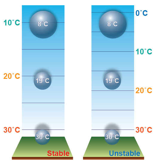
To see what I mean, check out the schematic below, which shows identical air parcels in a stable environment (left) and an unstable environment (right). Both parcels start with the same temperature and cool at the same rate as they rise and expand. The big difference is in the environmental lapse rate. Temperatures decrease more rapidly with increasing height in the unstable environment on the right, which allows the parcel to remain warmer (less dense) than its surroundings as it rises. Such a parcel would accelerate upward because of positive buoyancy if nudged from its initial position. Meanwhile, in the stable environment on the left, environmental temperatures decrease more slowly with increasing height, and the air parcel would be cooler (more dense) than its surroundings if nudged upward. In the stable environment, the parcel would sink back to its initial position because of negative buoyancy.
So, if the environmental lapse rate is relatively large (temperatures are decreasing fairly rapidly with increasing height), it's more likely that a rising parcel can remain warmer than its surroundings, and keep accelerating upward because of positive buoyancy (an unstable environment). But you might asking yourself what determines the rate that the parcel itself cools as it rises. As it turns out, parcels can cool at different rates as they rise:
- "Dry" air parcels, in which liquid water droplets are not forming (the parcel hasn't cooled to the point of net condensation) cool at a rate of about 10 degrees Celsius per kilometer (5.5 degrees Fahrenheit per 1000 feet) as they rise.
- "Moist" air parcels in which liquid water droplets are forming (because the parcel has cooled to the point of net condensation, causing clouds to form) cool more slowly as they rise, at an average rate of about 6 degrees Celsius per kilometer (about 3.3 degrees Fahrenheit per 1000 feet).
If you're wondering why air parcels in which net condensation is occurring cool more slowly than "dry" air parcels, recall that condensation is a warming process. The release of energy during condensation (formally called the "latent heat of condensation") to the surrounding air offsets some of the cooling that occurs as air parcels rise, resulting in a slower cooling rate overall. The rate of cooling in "moist" air parcels is not constant because it depends on just how much condensation is occurring, but you can think of 6 degrees Celsius per kilometer as an average.
The formation of liquid water drops in a rising air parcel, therefore, tends to extend positive buoyancy for a longer time on ascent because of the slower cooling rate in a "moist" parcel ("moist" parcels have a better chance to remain positively buoyant). But, ultimately, layers in the atmosphere are stable or unstable based on the environmental lapse rate within the layer. Layers in which temperatures decrease more rapidly than 10 degrees Celsius per kilometer (the rate at which "dry" parcels cool) are wildly unstable because all rising parcels are easily warmer than their surroundings. Fortunately, such layers are fairly rare and don't last very long in the atmosphere. On the other hand, layers in which temperatures decrease by less than the rate experienced by "moist" parcels are very stable because all rising parcels quickly find themselves cooler than their surroundings. Often times, the stability is "in between" because environmental lapse rates are between those experienced by "dry" and "moist" parcels. Such conditions are called "conditionally" unstable, because the fate of a rising parcel depends on the "condition" of whether it cools to the point of net condensation or not.
Forecasters also have to keep tabs on any process that causes temperatures to decrease more rapidly with increasing height in a layer of the atmosphere because that tends to decrease the stability in the layer. Layers can become less stable by either warming the bottom of the layer (perhaps you've heard a weather forecaster say something like, "The heat of the afternoon sun will destabilize the atmosphere"), or by cooling the top of the layer. That's right, cooling the air aloft can also be a destabilizing mechanism that can lead to positively buoyant air parcels and thunderstorms!
Now that you know what "stability" means and how meteorologists assess it, let's explore the types of clouds and precipitation that form in stable and unstable environments. Read on!