Prioritize...
At the completion of this section, you should be able to name and describe the clouds that form in an unstable atmosphere and the clouds that form in a stable atmosphere, including their observed characteristics. You should also be able to discern stratiform from convective precipitation on radar.
Read...
Now that we've covered the difference between stable and unstable environments, we can tackle the question of what kinds of clouds and precipitation form in each type of environment. As you're about to see, the stability of the atmosphere plays a big role in the types of clouds and precipitation that can form!
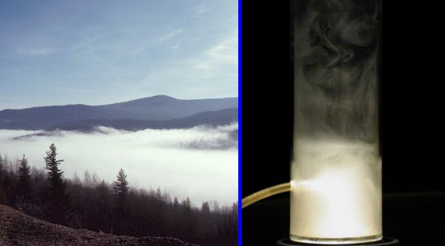
Let's start with clouds in an unstable environment. When the environment is unstable, air parcels are able to rise via positive buoyancy if nudged upward from their initial position (say, near the surface). To get a visual on this process, let's perform a little experiment. We'll start with a small Plexiglas cylinder into which we'll blow some smoke (to help us trace the movement of the air). Next, we'll put the cylinder on a hot plate and turn it on. What happens? As air parcels near the bottom of the cylinder warm up and become positively buoyant, convective eddies form and plumes of smoky air rise. In turn, cooler air that's higher up in the cylinder sinks, resulting in "convective overturning," the results of which you can see in the image below on the right.
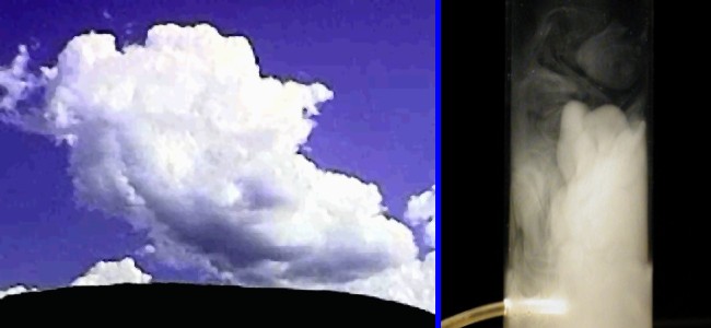
Our experiment in the smoky cylinder mimics what happens when the sun-baked ground heats the atmosphere from below causing air to become positively buoyant and rise via convection. If the air rises far enough that it cools to the point of net condensation, clouds will form, as shown in the image above on the left. Note the "bubbly" or "billowy" appearance to the convective cloud shown above on the left, which develops as eddies rise via positive buoyancy. Clouds forming in such unstable environments are of the cumulus variety, which as you may recall, means "heap cloud."
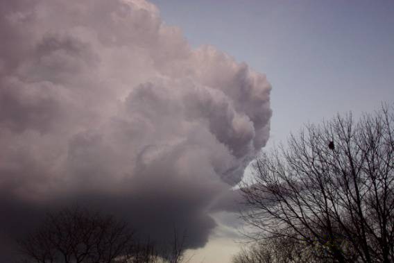
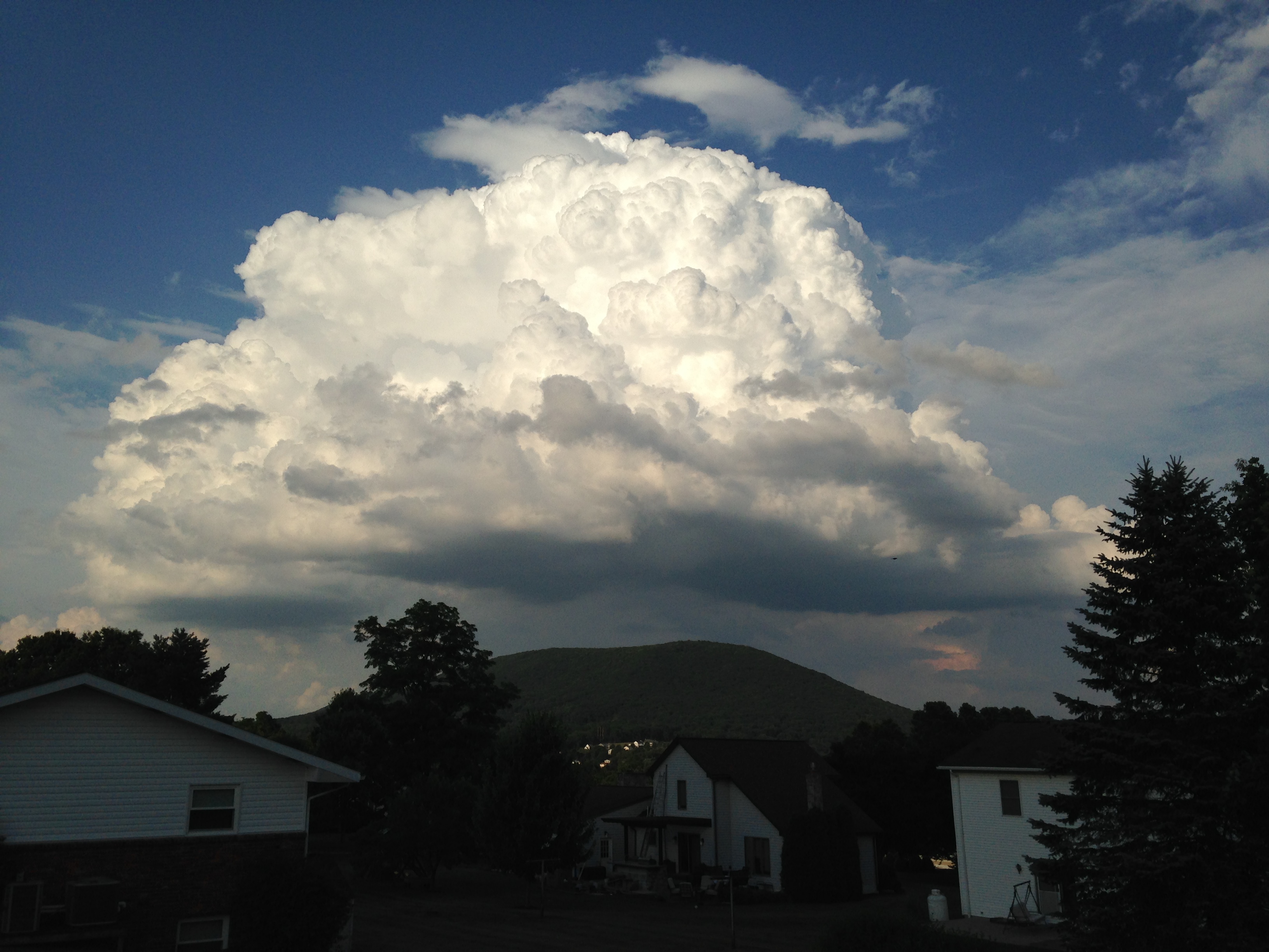
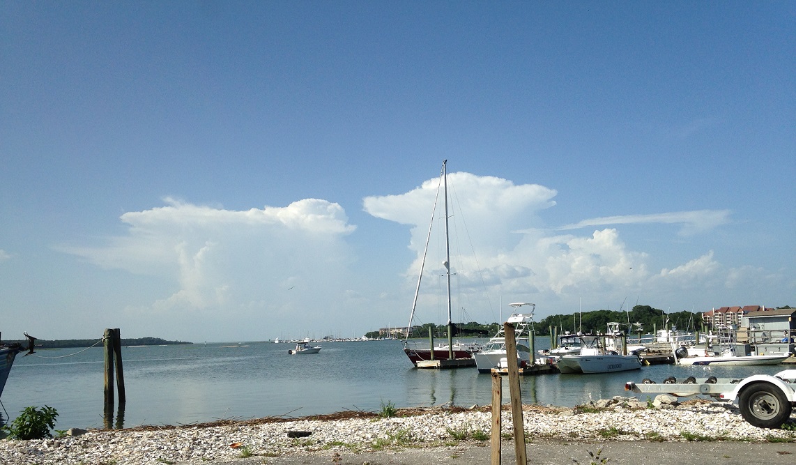
When the layer of instability in the atmosphere is fairly shallow, clouds are often "fair-weather cumulus" (credit: David Babb) which aren't very tall because the layer in which air parcels are positively buoyant is fairly thin. Air parcels rising within fair-weather cumulus clouds typically rise at speeds less than 1 meter per second (often much less). If the layer in which air parcels are positively buoyant is thicker, clouds can become "cumulus congestus" (credit: Steve Seman), also called "towering cumulus" clouds, which are taller and have faster upward velocities (owing to the deeper layer where upward accelerations occur). When the layer in which air parcels are positively buoyant is quite deep, clouds grow into "cumulonimbus clouds" (credit: Steve Seman), which produce precipitation, and can soar to the top of the troposphere (or even a little higher). At the extreme, upward velocities in cumulonimbus clouds can reach near 50 meters per second (more than 100 miles per hour), owing largely to strong positive buoyancy and upward accelerations through a deep layer of the troposphere.
I should also point out that the transition from a fair-weather cumulus to cumulus congestus to a precipitating cumulonimbus cloud isn't as simple as cloud drops growing via net condensation until they're large enough and heavy enough to fall. Cloud drops are typically much smaller than raindrops and can't grow large enough from net condensation alone. Indeed, other processes are at work to make raindrops. Cloud drops can collide and "stick together" within the turbulent air motions in the cloud, which helps the drops grow larger, and more importantly, ice crystals grow high up in the colder parts of the cloud (remember that most precipitation actually starts as snow in the cold upper troposphere).
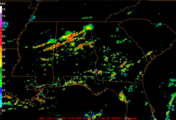
Precipitation that forms in unstable environments from cumulonimbus clouds comes in the form of showers and thunderstorms, which can be somewhat brief, dumping rain on some places while leaving surrounding areas totally dry. Even when cumulonimbus clouds organize into a line or cluster of thunderstorms (ahead of a cold front, for example), the area that gets precipitation can be larger but convective rains still tend to be relatively brief. Check out the 1745Z mosaic of composite radar reflectivity, showing thunderstorms over the Deep South on the afternoon of July 22, 2006, for example. Some thunderstorms are discrete (completely separated from other areas of precipitation), while other thunderstorms organized into lines and clusters of storms. Either way, the "splotchy" nature of the radar reflectivity is the hallmark of convective precipitation that formed in an unstable environment.
Now, what about clouds and precipitation in stable environments? At first, it might be tempting to think that clouds and precipitation don't form in stable environments at all, because air parcels are negatively buoyant (and don't accelerate upward). But, that's not true! Stable environments can certainly be favorable for stratus (layered) clouds to form. To see what I mean, let's return to our demonstration with the Plexiglas cylinder into which we've blown some smoke to trace the movement of the air. In this case, however, we'll place the bottom of a Plexiglas cylinder in a tub of ice to let the lower portion chill down for a while. Putting the cylinder on ice simulates the cooling of the ground (and a layer of air in contact with the ground) on a clear, calm night and actually makes the air in the bottom of the cylinder colder than air above it. Such an environment is quite stable since temperatures actually increase with increasing height.
Given the stable environment, it's not surprising that the cold, dense air simply stays at the bottom of the cylinder, as shown in the photograph below on the right. This is much like what happens during the formation of ground fog -- fog forms when stable air near the ground is cooled by the surface. This cooling can occur overnight when the ground loses more energy than it receives (this type of fog is called "radiation fog"). Or, the cooling of the air near the ground can occur as the relatively warm air passes over cold water or snow (which can result in "advection fog").
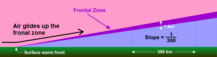
So, fog (a stratus cloud at the ground) forms in a nocturnally cooled layer of air next to the ground (which is extremely stable), but what about stratiform (layered) clouds above the ground? Stratiform clouds that form aloft don't have the luxury of the ground's nocturnal chill. Instead, the lifting of a layer of stable air by a low-pressure system is the most common way to achieve sufficient cooling for stratiform clouds to develop away from the ground. Such lifting by lows is often persistent and slow compared to fast, abrupt uplift in powerful thunderstorms. Indeed, upward speeds associated with stratiform clouds are typically gentle, averaging on the order of several centimeters per second or less.
Keep in mind that stable layers of air, if left undisturbed, resist upward displacement, so some external factor, such as overrunning, must do the heavy lifting. As an entire layer of air glides upward, it cools to the point of net condensation and clouds form. But, air parcels within this layer are negatively buoyant, so they don't accelerate upward. In fact, they would tend to sink if the process of overrunning wasn't forcing the entire layer to glide upward. Once air parcels' negative buoyancy becomes too great to be overcome by overrunning, parcels simply spread out horizontally, resulting in widespread, layered clouds. The clouds that form as a result of lifting a stable layer are typically rather shallow, meaning that stratiform clouds are much wider than they are tall (in stark contrast to cumulus congestus or cumulonimbus clouds). So, stratiform clouds naturally come by their name "stratus," (which, derived from Latin, means "to spread out").
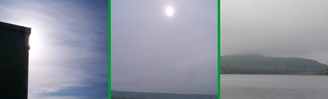
Moreover, stratiform clouds have fairly smooth bottoms and tops (think of the smooth top of a layer of fog) compared to cumuliform clouds, which look like uneven heaps of cotton. You can see the visual "smoothness" of stratiform clouds in the images below, which show cirrostratus (left), altostratus (middle), and stratus (right). The visual cues that characterize these clouds (in terms of their height and thickness) provide key clues to weather forecasters and savvy weather watchers about impending weather, as you may recall from our study of the progression of clouds associated with warm fronts.
When stratiform clouds precipitate (nimbostratus), rain, snow, sleet, or freezing rain tends to be steady, relatively long-lived (a few to several hours), and spread out over a fairly large region. To see what I mean, check out the 12Z surface analysis on December 16, 2010. At the time, there was a low-pressure system centered over the Tennessee-Kentucky border with a warm front extending southeastward to eastern South Carolina. If you closely examine the station models, you will note a blob of stratiform precipitation over parts of the Carolinas, Ohio Valley and the Middle Atlantic States (primarily freezing rain and light snow). The mosaic of composite reflectivity at 12Z on December 16, 2010 confirms the breadth of the stratiform precipitation north of the low's warm front.
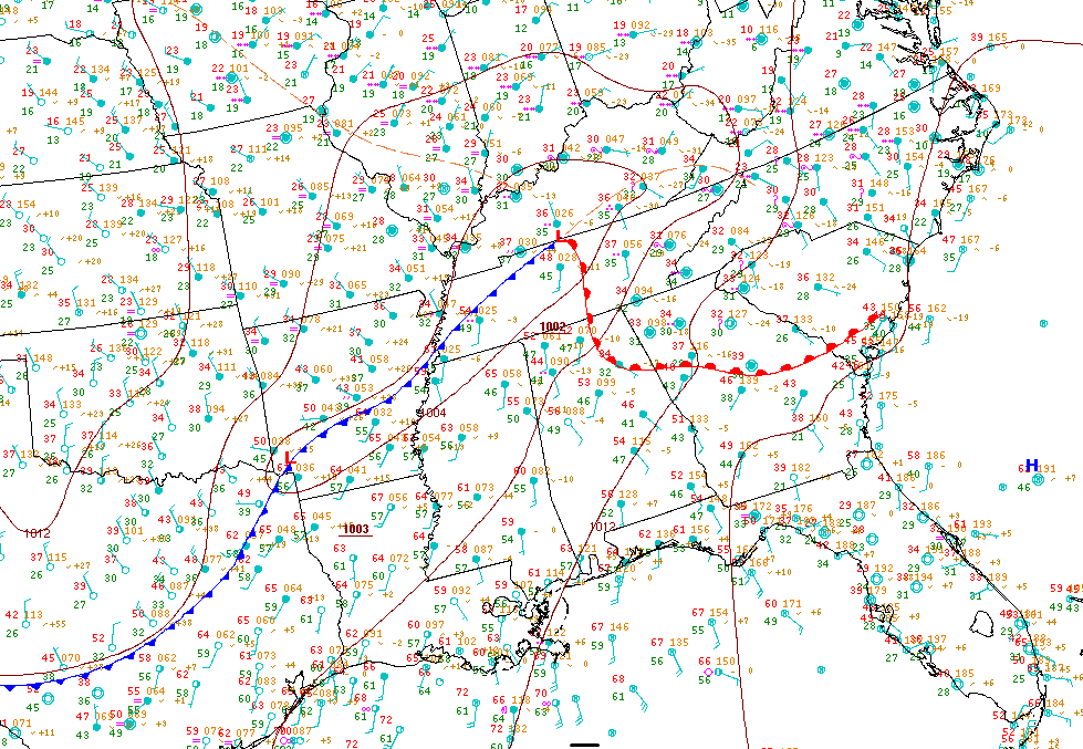
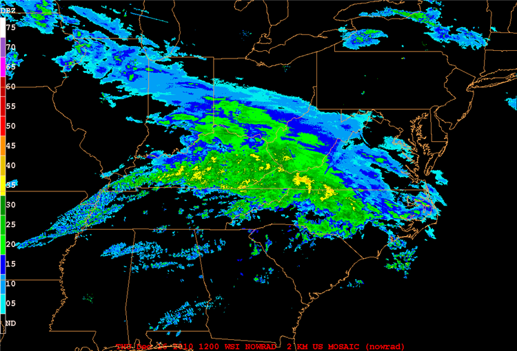
So, the gentle, broad upward motion that occurs in stable environments results in layered, stratiform clouds and large areas of steady precipitation (if nimbostratus clouds form). That's in stark contrast to the potentially vigorous upward motions caused by positively buoyant air parcels in unstable environments. Convective updrafts can lead to heavy (although often brief) showers and thunderstorms that may only affect limited areas. The vigorous upward motion can also ultimately put the "thunder" in thunderstorms through the creation of lightning. We'll tackle the basics of lightning and lightning safety up next!