Prioritize...
In this section, make sure that you can describe and explain the effects of latitude and proximity to large bodies of water seasonal temperature variations.
Read...
In the last section you learned that seasons (that is, yearly temperature trends that occur over a large region of the earth) are created by the tilt of the earth's axis and that the amount of solar radiation impinging on a surface depends on the angle at which it strikes the surface. If we look at slightly smaller regions over shorter time spans, we'll discover that characteristics of the earth itself act as temperature controllers. Specifically, the average surface air temperature across the earth's surface depends on location. The "big three" controllers of temperature based on location are latitude, proximity to bodies of water, and altitude (we'll deal with the first two in this section).
Latitude
In the last section, we discussed the importance of sun angle on determining the seasons. A more direct sun angle in the northern hemisphere causes the warmth of summer, while simultaneously, a lower sun angle in the southern hemisphere brings less solar heating power and the chill of winter. But, the earth is (approximately) a sphere, and its surface is curved. The curvature of the earth's surface means all points in a given hemisphere are not receiving incoming solar radiation at the same angle, regardless of season.
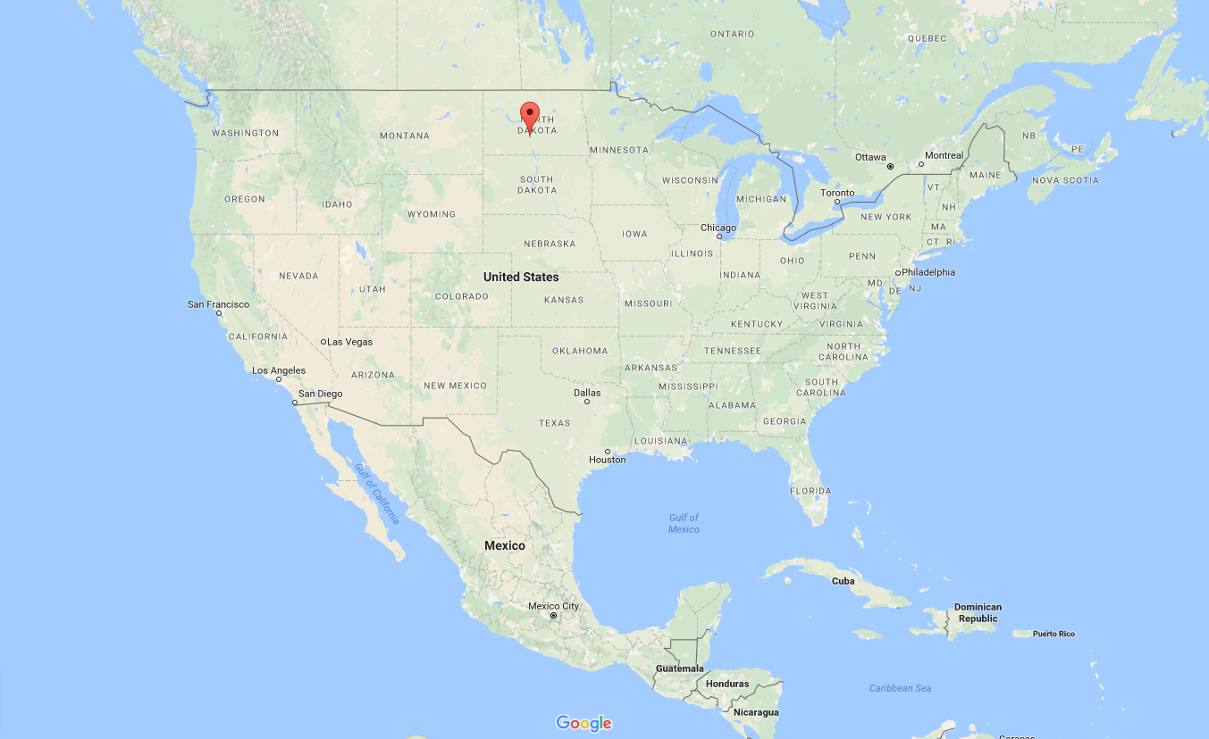
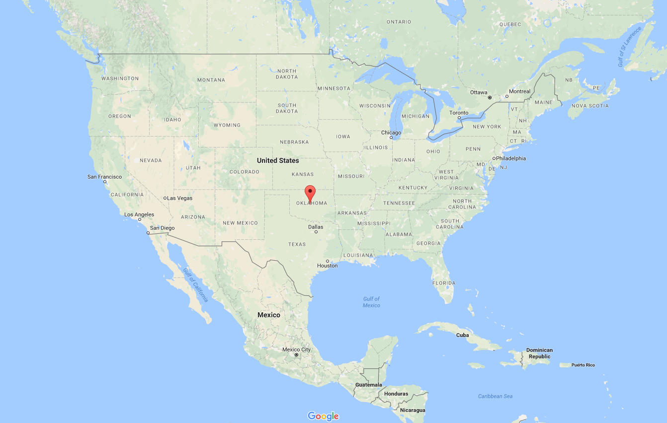
The maximum height that the sun reaches at local "solar noon" (the time of day when the sun is highest in the sky) on any given day, and thus the maximum angle at which the radiation strikes the earth, depends on the date at the latitude of your location. For example, consider two locations -- Bismarck, North Dakota (located at 46.5 degrees North latitude) and Oklahoma City, Oklahoma (located at 35.2 degrees North latitude). Clearly, Bismarck's latitude is greater than Oklahoma City's (Bismarck is farther from the equator). Using the NOAA Solar Calculator (it's a neat tool, if you want to check it out) along with some math which I'll skip here, I calculated the peak sun angles and corresponding percentages of the maximum possible solar radiation (often called the "direct beam") for December 21 (near the winter solstice) and June 21 (near the summer solstice) at Bismarck and Oklahoma City. The results are in the table below:
| City |
Peak Sun Angle (December 21) |
% of the Direct Beam (December 21) |
Peak Sun Angle (June 21) |
% of the Direct Beam (June 21) |
|---|---|---|---|---|
| Bismarck | 19.8 degrees | 34 percent | 66.7 degrees | 92 percent |
| Oklahoma City | 31.1 degrees | 52 percent | 78.0 degrees | 98 percent |
You should take a couple of important messages from these numbers. First, the peak sun angle at the higher-latitude city (Bismarck) is lower than at Oklahoma City near both solstices. As you know from the last section, a lower sun angle means Bismarck consistently receives less intense solar radiation compared to Oklahoma City, ignoring clouds of course. To confirm, note that Bismarck's percentage of possible solar radiation compared to the "direct beam" is lower near both solstices.
Furthermore, the numbers in this table should match your experiences. Perhaps you've noticed that during the winter, the sun at local "solar noon" isn't as high in the sky as it is in the summer. These numbers support that observation: at both cities, the peak sun angle is much larger (meaning the sun is higher in the sky) near the summer solstice than near the winter solstice.
So, Oklahoma City consistently receives more radiation than Bismarck throughout the year because the sun's angle is always higher in Oklahoma City. How does this fact impact average temperatures? Check out the graph below, which compares daily average high temperatures at the two cities.
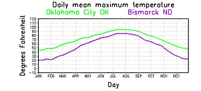
As we would expect, Oklahoma City is, on average, warmer than Bismarck, because Oklahoma City consistently receives more solar radiation. But, also notice that Bismarck has a much wider range in average temperatures than does Oklahoma City. Average high temperatures in Bismarck increase from about 20 degrees Fahrenheit in January to about 85 degrees Fahrenheit in July (a range of 65 degrees Fahrenheit), while Oklahoma City's average high temperatures increase from about 44 degrees Fahrenheit in January to 95 degrees Fahrenheit in July (a range of 51 degrees Fahrenheit). That's because the higher-latitude city (Bismarck) experiences a greater variation in solar radiation between winter and summer (34 percent to 92 percent of the sun's direct beam) than Oklahoma City (which receives 52 percent to 98 percent of the sun's direct beam during the year). So, a location's latitude impacts not only its average temperatures, but also the range in temperatures during the year. We can generalize our findings from Bismarck and Oklahoma City into the important "lesson learned" below:
Proximity to Bodies of Water
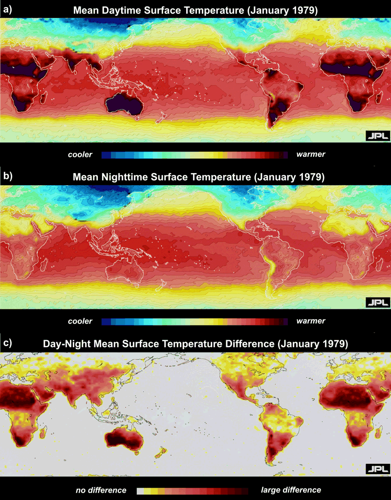
To begin our discussion on the effect of large bodies of water on local temperatures, consider this color-coded temperature map (constructed from NASA satellite data). The top map indicates the average daytime air temperatures in January 1979, and the middle map represents the average nighttime temperatures during the same month (on both maps, brown represents the hottest regions and temperatures decrease from red to yellow to light blue to dark blue, which represents the coldest regions).
The bottom map represents the difference between daytime and nighttime temperatures during January 1979. The whitish appearance of Earth's oceans means that there was little or no change between daytime and nighttime temperatures over the course of the month. This map tells us that water is particularly slow to warm or cool -- much slower than land. That's because water has a heat capacity that is three times that of land, which means that water requires about three times as much energy compared to a similarly sized volume of land to achieve the same temperature increase. Because water, with its relatively high heat capacity, is relatively slow to warm or cool, we might expect locations that are near large bodies of water to have smaller seasonal temperature changes, and indeed that's the case. For what it's worth, locations near large bodies of water tend to have smaller diurnal (daily) temperature changes, too, because of the moderating influence of water.
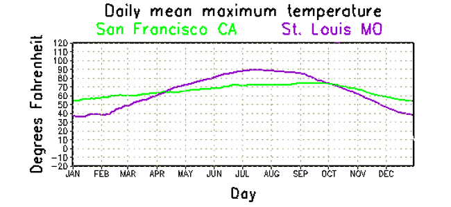
If you examine the average temperatures for a west-coast city such as San Francisco, where prevailing winds blow from the ocean most of the time, you can observe the moderating influence of the Pacific which limits the variation in temperature from day to day and month to month. Indeed, note the relative flatness of the plot of daytime average high temperatures at San Francisco compared to St. Louis, Missouri (both cities lie at approximately the same latitude). The flatness in San Francisco's trace of daily average highs indicates a smaller annual variation in temperature. Indeed, average daily highs during summer at San Francisco are not nearly as high as St. Louis. During winter, however, the average daily highs in San Francisco are higher than St. Louis, again due to the moderating influence of the ocean. Practically speaking, the Pacific Ocean keeps San Francisco from getting hot in summer and cold in winter. Also note that the average high temperatures at San Francisco peak later in the year (September) compared to St. Louis (where they peak in July), because the high heat capacity of water keeps ocean temperatures slowly rising through the summer into September.
Oceans do not own a monopoly on moderating temperatures. To a lesser extent, large lakes, rivers, and seas modify air temperatures. For example, the moderating effects of Lake Ontario and the Finger Lakes transform western New York into a favorable place to grow grapes for making wine. Because large bodies of water cool much more slowly than land, milder air overlying the Finger Lakes delays the first frost (courtesy: PlantMaps.com) of autumn, extending the growing season and allowing grapes to adequately ripen before harvest (note in the image the later average date for the first frost in the region south of Lake Ontario). We say that bodies of water cause temperatures to "lag" those farther away from the water because air temperatures surrounding large bodies of water will stay milder in the fall and winter, but will also be slow to warm during the spring and early summer (because the nearby water will be slow to warm).
I should quickly point out that this effect is greater for locations "downwind" of the large body of water. For example, in the United States, the moderating influence of the Pacific Ocean over the course of individual days and through the entire year is more dramatic for West Coast cities than the moderating influence of the Atlantic Ocean is for cities on the East Coast. Why? Weather systems at these latitudes tend to move from west to east, and winds commonly blow onshore from the Pacific Ocean, ushering the air over the ocean into West Coast cities. Along the East Coast, winds sometimes blow onshore from the Atlantic, but not as often, which lessens its moderating influence, on average.
Other characteristics of the earth's surface beyond simply land versus water can alter local heating characteristics (and impact local temperatures), too. Urban landscapes absorb radiation differently than rural landscapes, etc., but we'll talk more about some of these finer details later on. For now, we have to leave the surface of the earth and start thinking about elevation. It's time to get vertical! Read on.