Prioritize...
In this section, make sure that you can describe and explain the effects of altitude on a location's average yearly temperatures. You should also be able to apply terms associated with vertical temperature variations, such as lapse rate, environmental lapse rate, and tropopause.
Read...
In the last section, we saw the impact that latitude has on incoming solar radiation and seasonal temperature variations. But, now, we have to account for another characteristic of earth's surface: it has varying terrain. Earth has mountains and valleys, which range in elevation from below sea level (such as California's Death Valley) to over 29,000 feet above sea level (the peak of Mount Everest). The varying altitudes of the earth's surface impact average temperatures, too, and perhaps in a way that's not intuitive.
Altitude
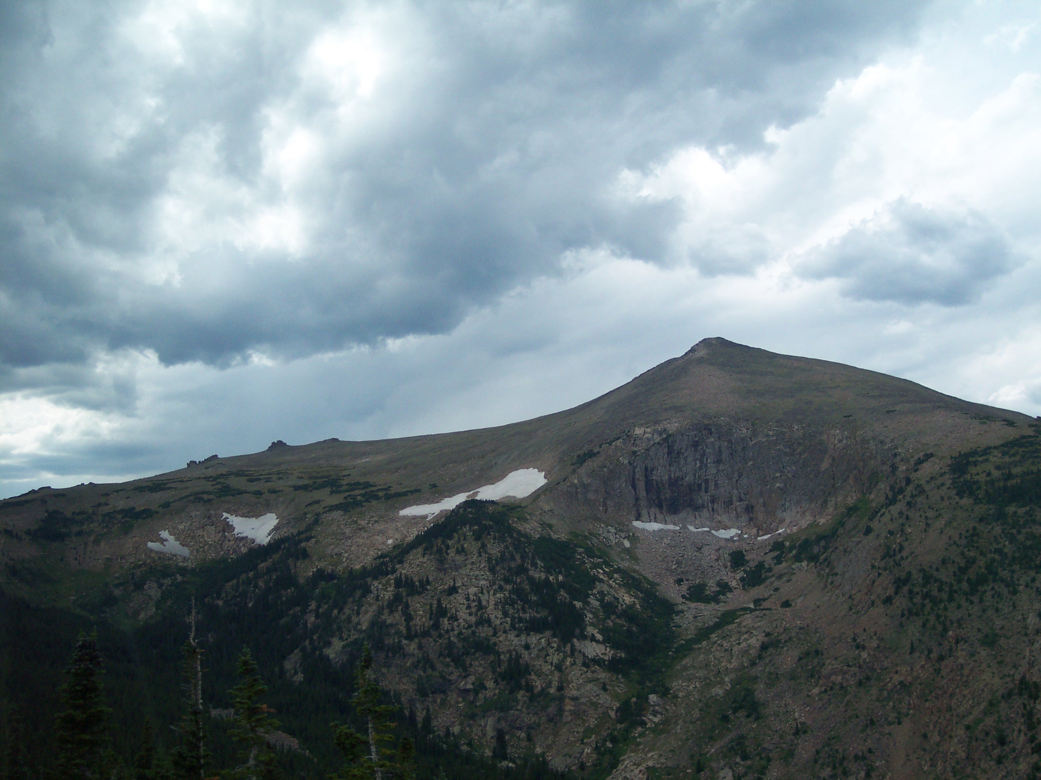
How does altitude impact temperatures? Let me start with a personal story (perhaps you've experienced something similar). On a hot, summer day during August 2006, my family was in the midst of a cross-country road trip. As we approached Denver, Colorado from the north at elevations near 5,000 feet, temperatures were near 90 degrees as the clock turned to early afternoon. My family then drove west into Rocky Mountain National Park, where some of the roads crest over 12,000 feet. As we drove higher, temperatures dropped all the way to the low 50s, and sight-seers were wearing jackets at the scenic overlooks. Even in August, some patches of snow (credit: Steve Seman) still remained from the snowstorms of winter and spring. Indeed, the relative chill of such high elevations is typical, and you might be wondering if mountains are closer to the sun, why are they colder?
Temperatures typically decrease with increasing height in the lower part of the atmosphere, and the reason for these temperature decreases is that the primary heat source in this region is the earth's surface. Remember that the earth's atmosphere is relatively transparent to solar radiation -- only the earth's surface absorbs most solar radiation. The absorption of solar radiation, of course, warms the ground, which then transfers its heat to the atmosphere via conduction, convection, and the emission of infrared radiation. The end result is that the farther away from the earth's surface you are, the colder the surrounding air.
Of course, mountain tops are still the surface of the earth and thus should have the same heating properties as lower elevation surfaces, but the key to this conundrum is that while the surface of the mountaintop may indeed heat up just like any similar surface, the air surrounding the mountaintop is vastly cooler than air at lower elevations. Therefore, as air near the surface of a mountain warms via conduction, air parcels over the mountaintop quickly become positively buoyant and rise. As convection quickly transports heat energy away from the mountaintop, the warm air is quickly replaced by much cooler air. If the wind is blowing, this effect is compounded, and the end result is that air at higher elevations (even on mountain tops) stays cooler than air at lower elevations.
As an example, consider two cities: Columbia, Missouri and Eagle, Colorado. Both cities lie at the same latitude and are located near the center of the United States. The difference between these two cities is elevation. Columbia's elevation is 705 feet above sea-level; Eagle's elevation is 6,600 feet above sea-level. Below is a comparison of the mean high temperatures for these two cities.
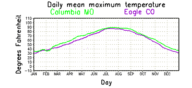
As you can see in the graph, Eagle's higher elevation causes it to have a slightly lower average high temperature than the lower-elevation city of Columbia.
The fact that temperatures tend to decrease with increasing altitude is an important part of your understanding about the structure of our atmosphere, so let's take a closer look at this issue and put a few numbers to it. First, let's start with an important term -- lapse rate. Formally, a lapse rate is the rate of decrease in temperature with increasing height, and while atmospheric lapse rates vary from time to time and place to place, the average environmental lapse rate is about 6.5 degrees Celsius per kilometer (3.6 degrees Fahrenheit per 1000 feet). In other words, for every kilometer of ascent, on average, the temperature decreases by 6.5 degrees Celsius (this applies to roughly the lowest 10 kilometers of the atmosphere).
Take special note that the "decrease" in temperature is built right into the definition, so when temperatures are decreasing with increasing height, lapse rates are expressed as positive numbers (as with the average environmental lapse rate). Only when a temperature inversion is present (temperatures increase with increasing height) is a lapse rate expressed as a negative number. So, if the lapse rate is -5 degrees Celsius per kilometer, temperatures are increasing by 5 degrees Celsius for every kilometer of ascent (it's getting warmer as you go up). That might not be intuitive from the negative number, so make sure you're aware of this quirk involving lapse rates.
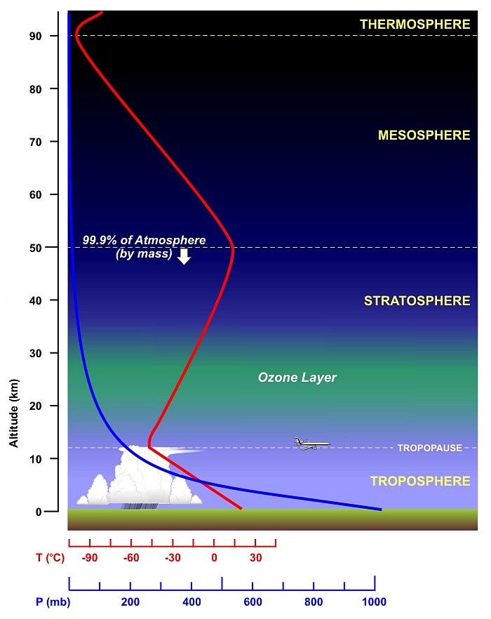
You might be asking yourself, "if temperatures typically decrease with increasing height in the lower part of the atmosphere, is there a point where it stops getting colder as altitude increases?" The answer is "yes!" The lowest layer of the atmosphere, where most of the processes we call "weather" occur, is called the troposphere. Temperature decreases with increasing height in the troposphere (on average) until we reach the tropopause, which is the transition zone between the troposphere and the layer above, called the stratosphere.
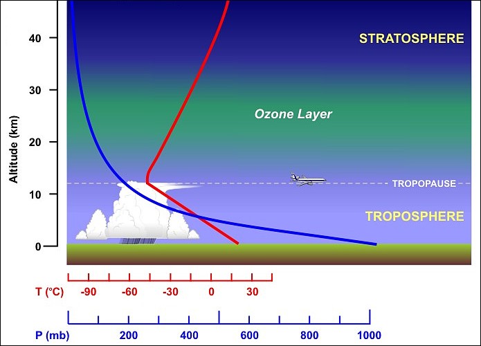
The graph above shows the idealized structure of the troposphere and stratosphere, with temperatures (red line) decreasing with increasing height until the tropopause, and then increasing with increasing height in the stratosphere. While the troposphere extends to an altitude of about 10 kilometers, on average, its height depends on latitude (it's higher at lower latitudes near the equator), along with other weather conditions. The atmosphere does contain layers above the stratosphere, but 99.9 percent of the air molecules that make up the atmosphere reside in the bottom two layers.
So, altitude is a major controller of average temperature, and along with latitude and proximity to bodies of water, altitude helps to determine average temperatures in a region throughout the year. But, what helps determine how temperatures change from one day to the next? Let's shift gears now and think shorter term, and examine some temperature controllers that impact day-to-day weather changes.