Prioritize...
At the end of this section, you should be able to define cold, warm, and stationary fronts, and identify them by their symbols. You should also be able to describe temperature trends associated with the passage of cold and warm fronts.
Read...
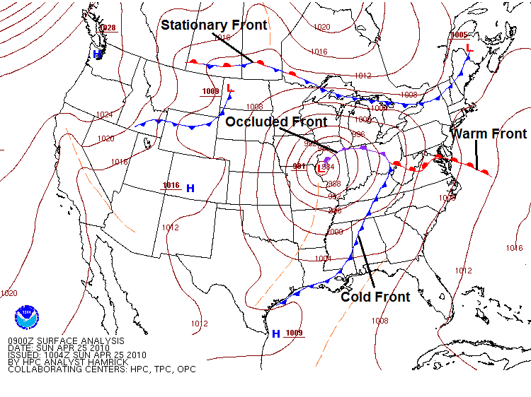
You just learned that air masses acquire the characteristics of their underlying land or water surface by remaining in place for an extended period of time, but air masses don't remain nearly stationary forever. Eventually, air masses move around, and that's when a particular location can see significant changes in the weather. Those big changes happen near fronts, and we're going to concentrate on three main types of fronts here -- cold fronts, warm fronts, and stationary fronts. There's also a fourth type of front, called an occluded front, which I'll briefly introduce, although we'll cover them more later on in the course. If you've ever looked at a surface weather map on television or online, you've probably seen the symbols for cold, warm, stationary, and occluded fronts, as shown on the surface analysis from April 25, 2010, below (I've labeled each type of front).
So, what's the difference between these types of fronts? Let's explore.
Cold fronts
Simply put, a cold front marks the leading edge of an advancing cold air mass, and is marked on a weather map as a chain of blue triangles pointing in the direction of movement (toward the warmer air). Meteorologists track the winds on the cold side of the front to see if cold air is advancing. Given that a cold front marks the leading edge of advancing colder air, you can probably guess that temperatures decrease after a cold front passes a given location. Indeed, that's usually (although not always) the case. Furthermore, dew points typically drop in the wake of a cold frontal passage, since the advancing colder air masses are often drier, too.
To see what I mean, check out the graph below, from Findlay, Ohio from February 14, 2015. On this particular morning, a strong cold front, marking the boundary between continental-Polar (cP) air and continental-Arctic (cA) air was barreling through the Midwest. The cold front passed through Findlay around 15Z (10 A.M. local time). Can you spot the footprint of the passing front in the temperature and dew point traces on the graph (note that local time is expressed at the bottom)?
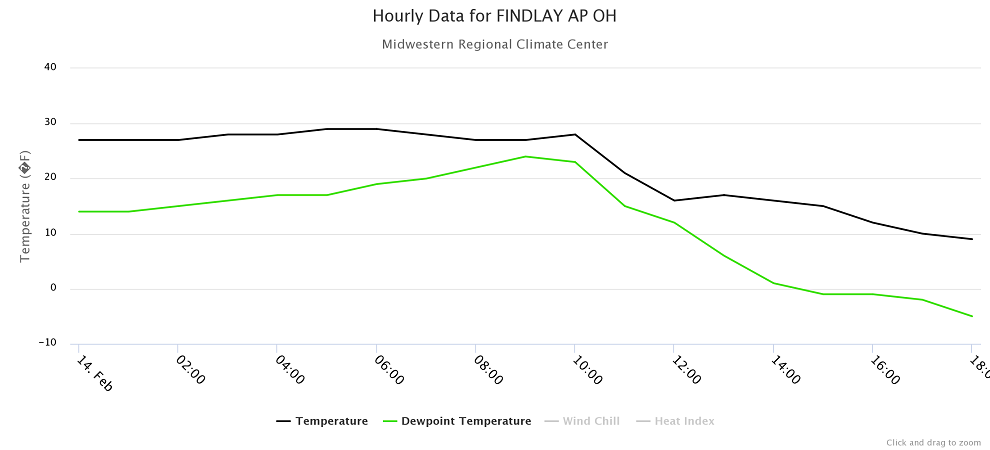
Note that at 10 A.M. local time, both temperature and dew point started a notable decline. The 10 A.M. temperature in Findlay was 28 degrees Fahrenheit, but just two hours later at noon, the temperature had dropped to 16 degrees Fahrenheit as cA air rushed in. By evening, temperatures were dropping into the single digits. Even more notable was the decline in dew points. At 10 A.M., the dew point was 23 degrees Fahrenheit, but just four hours later at 2 P.M., the dew point had dropped to 1 degree Fahrenheit (and eventually fell below zero). Remember, cA air is the coldest of the cold and the driest of the dry, so such temperatures and dew points are commonplace in cA air masses during winter.
While temperatures and dew points usually decline, and can sometimes really plunge in the wake of a cold front, occasionally temperatures don't drop much (if at all) behind a cold front. Especially during the summertime, strong solar heating behind a cold front can help warm things up and erase the temperature drop entirely.
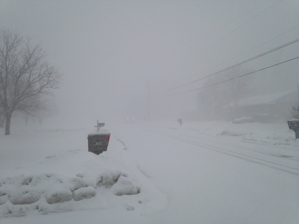
In addition to typically bringing a drop in temperatures and dew points, the other weather associated with cold frontal passages can be quite dramatic. Cold frontal passages are often accompanied by sharp changes in wind direction, gusty winds, and precipitation. Arctic cold frontal passages like the one on February 14, 2015 are notorious for producing dangerous snow squalls (bursts of heavy snow and strong winds) in the Great Lakes region. In fact, when the Arctic cold front passed through State College, Pennsylvania later on February 14, a snow squall reduced visibility to a few hundred feet (credit: Steve Seman), creating dangerous driving conditions.
Warm Fronts and Stationary Fronts
If a cold front marks the leading edge of advancing cold air, then a warm front must mark the leading edge of advancing warm air, right? It's actually not that simple. To see what I mean, take a look at the idealized weather maps below:
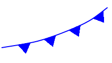
The image on the left shows a classic warm front, which is marked by a chain of red semicircles directed toward the cold air. This boundary is a warm front because the cold air is retreating (winds on the cold side of the front are blowing away from the front). Why is the retreat of cold air important? Because cold air is more dense than warm air at the surface of the earth, cold air is "the boss" and can push its way around as it pleases. So, warm air can only advance if cold air retreats, and the presence of a warm front signals that cold air is retreating.
What about the boundary on the right? Is it a warm front? The winds in the warm air (south of the boundary) make it look like the warm air is advancing, but that's not the case because the cold air is not retreating: The winds on the cold side of the front are actually blowing slightly toward the front, meaning this is actually a cold front. So, determining the type of front is a matter of figuring out whether the cold air is retreating or advancing (and forecasters do so by examining the winds on the cold side of the front).
When a warm front passes a given location, temperatures tend to increase (as colder air retreats and a warmer air mass arrives). Winds often change direction, and clouds and precipitation can occur near warm fronts, too, though the weather changes are typically not as sudden and dramatic as they can be with cold frontal passages.
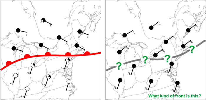
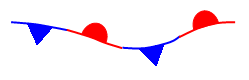
If cold air is neither advancing or retreating, then we have a stationary front, which is marked by a chain of alternating blue triangles and red semicircles. In such a scenario, winds on the cold side of the front blow mostly parallel to the front, resulting in a frontal movement of less than five knots (fronts moving at less than 5 knots are considered stationary). Again, the winds on the warm side of the front don't really matter: Cold air is the boss, and if the cold air isn't advancing or retreating, the front is stationary.
Finally, there's a fourth type of front, called an "occluded front," marked by purple triangles and semicircles alternating on the same side of the front. Occluded fronts tend to develop late in the life of low-pressure systems, and we'll talk a bit more about them later in the course. But, the bottom line for now is that the temperature and dew point changes, and the other "active" weather near fronts are really important for weather forecasting. A bad forecast for the movement of a strong front could mean huge forecast errors, and maybe you end up choosing to wear a t-shirt and shorts based on the forecast, when you really needed a sweater (brrrrr!). For now, however, let's explore just how temperature changes at a given location in the wake of a front's passage. Up next, we'll focus on the movement of warm and cold air by the wind. Read on.