Prioritize...
When you've finished this page, you should be able to explain air mass formation, name and describe the types of air masses, as well as discuss their source regions. You should also be able to define and describe "fronts" and describe the placement of fronts on weather maps.
Read...
So far, we've been talking about the controllers that affect the average temperature patterns all across the globe. In other words, we've been talking about temperature controllers that shape a region's climate. But, obviously, temperature changes from day to day (sometimes by quite a lot). So, what factors control the variations that we tend to notice on a daily basis? Let's explore.
For starters, weather forecasters track large blobs of warm and cold air, called "air masses," around the globe. By definition, an air mass is a large blob of air with horizontal dimensions of several hundred to a couple of thousand miles, within which temperatures and moisture (dew points) at the surface (or at any other arbitrary altitude) are fairly uniform (they don't change very much with distance). In other words, temperature and moisture gradients within an air mass are small.
Essentially, air masses acquire their relatively uniform surface temperature and moisture characteristics by remaining over one region (the source region) for an extended period of time, and acquiring the characteristics from the underlying ground or body of water. For example, an air mass that sits over a warm, tropical ocean for a long period of time will become warm and humid. On the other hand, an air mass that sits over the very cold, ice-, and snow-covered ground near the North Pole will be very cold and dry.
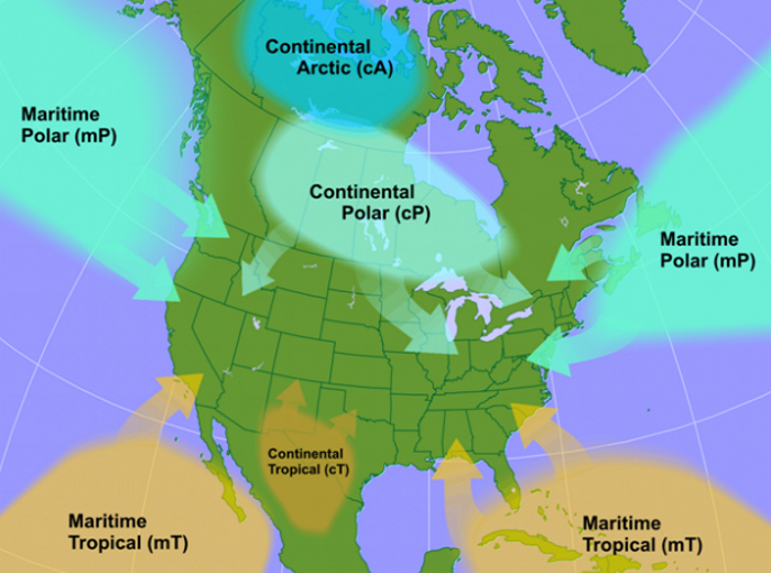
Meteorologists identify five main types of air masses, with designations like "maritime" (originating over the ocean) or "continental" (originating over land). The image below shows the source regions for the air masses that impact North America.
Let's break down these air masses and their specific characteristics:
- maritime-Tropical (mT): As its name suggests, a maritime-Tropical air mass forms over a tropical body of water. Given that tropical waters are typically warm, the overlying air becomes warm and humid (meaning that mT air masses have high dew points). Of course, summer mT air masses are the most stifling, particularly in the Deep South, where daytime temperatures often reach the 90s while merciless and muggy dew points edge toward the middle 70s or higher. The Gulf of Mexico, Caribbean Sea, and the tropical waters of the western Atlantic and eastern Pacific are also common source regions for mT air masses that affect the contiguous United States.
- continental-Tropical (cT): A hot, dry (meaning low dew points) air mass that originates over desert regions. In summer, temperatures in cT air masses can soar to more than 100 degrees Fahrenheit, but the low dew points often (perhaps jokingly) cause some folks to refer to the feeling in the air mass as "a dry heat." cT air masses that impact the United States tend to originate over Mexico and the Southwest United States.
- continental-Polar (cP): An air mass that forms over cold land. Chilly cP air masses often have low dew points, as well. While cP air masses in the summer might be considered refreshing, winter cP air masses are far more chilling, particularly over the northern-tier states, where daytime temperatures below 32 degrees Fahrenheit are the norm and dew points as low as the single digits often increase the demand for lip balm at local stores. Canada is the most common source region for cP air masses in the contiguous United States.
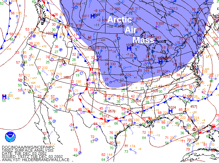
- continental-Arctic (cA): Winter's most frigid air masses. cA air masses are the coldest of the cold and the driest of the dry. Cold and dry cA air masses originate over the frozen hinterlands of Siberia and northern Canada, and to see just how cold and dry they can be in the winter, check out the 18Z surface analysis for December 3, 2002. Note the low temperatures and extremely low dew point temperatures on the station models along the U.S. / Canadian border. Temperatures and dew points in the single-digits above zero, or below zero degrees Fahrenheit are common.
- maritime-Polar (mP): An air mass that brings chilly conditions, but has relatively high dew point temperatures (that are often close to the air temperature). mP air masses typically originate over high-latitude bodies of cold water, and in the United States, mP air masses regularly spread from the Pacific Ocean into the Pacific Northwest states. Meanwhile, along the East Coast, mP air from the Northt Atlantic Ocean can invade coastal New England, bringing fog and keeping daytime temperatures in the upper 30s or 40s from eastern Long Island to Maine even in spring.
The Connection Between Air Masses and Fronts
While air masses are known for their relatively uniform temperature and moisture (dew point) characteristics, the edges of air masses are areas where the weather is anything but uniform. For example, if you have a maritime-Tropical (mT) air mass (warm and humid) adjacent to a continental-Polar (cP) air mass (cold and dry), temperature and dew point are bound to change quite a bit near the transition zone between air masses! Meteorologists have a name for the boundary that separates contrasting air masses -- a front. Not surprisingly, fronts lie in zones with large contrasts in temperature and dew point (large gradients of temperature and dew point).
For some quick background, the term "front" has roots traceable to World War I when opposing infantries clashed along battle lines called "fronts." Shortly after the war, a group of observant Norwegian meteorologists adopted the military term to describe zones where opposing cold and warm air masses met and vied for control. Befitting their wartime origin, fronts are often sites of active weather, with clouds and precipitation often drawing the battle lines between opposing air masses.
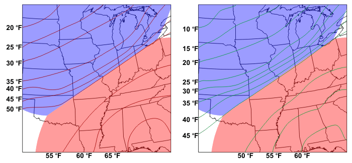
On the idealized weather map above, a continental polar (cP) air mass from Canada abuts against a maritime tropical (mT) air mass that originated over the Gulf of Mexico. Note the slight and gradual change in temperature and dew point with increasing distance from the center of each air mass. Furthermore, focus your attention on the narrow zone where the two air masses meet. Clearly, the gradients in temperature and dew point are large near the intersection of two air masses.
By convention, operational weather forecasters place fronts just on the warm side of the temperature gradient. In other words, a front lies just on the warm side of the narrow ribbon of tightly packed isotherms that mark the boundary between the two contrasting air masses. Although fronts can indeed be located on maps that do not have isotherms plotted, it sure helps to have them when looking for fronts.
Recalling our study of gradients from earlier in the course, I mentioned that areas with large gradients tend to be areas where interesting weather happens, and fronts give us a great example. Big changes in temperature, dew point, wind speed and direction, as well as clouds and precipitation can all come with the passage of a front. We'll break down the different types of fronts and the temperature trends that go along with their passage coming up in the next section.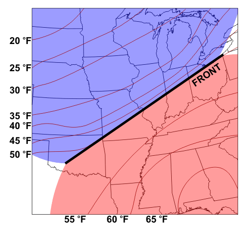