Prioritize...
After you've completed this section, you should be able to describe the conditions under which a thunderstorm would be considered "severe," and be able to interpret the meaning of a severe thunderstorm watch, severe thunderstorm warning, tornado watch, and tornado warning.
Read...
All thunderstorms can be dangerous because they produce lightning. But, some thunderstorms pack more of a punch than others, bringing a variety of serious weather hazards. In order to help the public prepare for the risks associated with thunderstorms, the National Weather Service formally classifies a storm as "severe" if it produces at least one of the following:
- a tornado (a rapidly rotating column of air in contact with the ground and a cloud above)
- hail at least one inch in diameter (the size of a quarter)
- straight-line winds of at least 50 knots (58 miles per hour)
Why were these particular criteria chosen? Well, chances are, if a thunderstorm produces at least one of the above, it's more likely to damage property and / or endanger lives. Note that the formal definition of a severe thunderstorm doesn't cover all thunderstorm hazards; it says nothing about lightning or flash flooding (although some other nations do, indeed, include flash flooding in their definition of severe thunderstorms). So, just because a thunderstorm doesn't meet the official definition of "severe" doesn't mean it can't produce damage or endanger lives.
Still, formally classifying thunderstorms as severe helps forecasters alert the public on days when the risks from thunderstorms are heightened. In the United States, a branch of the National Weather Service called the Storm Prediction Center (SPC), headquartered in Norman, Oklahoma is responsible for monitoring conditions that could favor severe thunderstorms anywhere in the country.
If SPC identifies an area with favorable conditions for an organized outbreak of severe thunderstorms, they will choose to issue either a severe thunderstorm watch or a tornado watch for that region. What do these watches mean?
- A severe thunderstorm watch means that severe thunderstorms are possible and that you should be prepared.
- A tornado watch means that severe thunderstorms with multiple tornadoes or particularly strong tornadoes (in addition to other severe weather threats) are possible and that you should be prepared.
Severe thunderstorm and tornado watches are fairly large, typically covering tens of thousands of square miles (roughly the size of a state or perhaps parts of several states), and are in effect for several hours (perhaps as many as six to eight hours), but watches can be canceled, re-issued, or modified as conditions dictate. I like to think of severe thunderstorm and tornado watches as an initial "heads up" of sorts, aiming to get the public's attention that there might be severe weather (damaging straight-line winds, large hail, or tornadoes) in the coming hours, so that they can stay alert and be prepared.
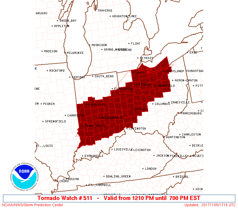
To see an example of a tornado watch, check out the image below showing Tornado Watch #511, issued by SPC on November 5, 2017 at 12:10 PM EST, in effect until 7 PM EST (nearly seven hours). Watch areas, like this one, typically resemble large parallelograms, but are really issued by county. All of the counties shaded in red were part of the tornado watch, which highlighted a swath covering parts of Indiana and Ohio, including cities like Indianapolis, Dayton, Toledo, and Cleveland.
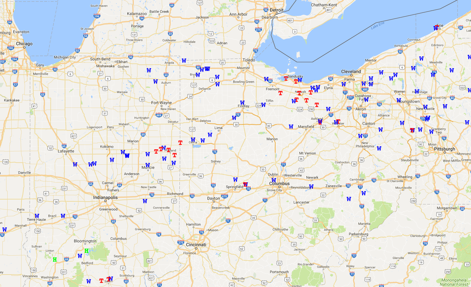
While no forecasters are perfect, the forecasters at SPC are very good at what they do, and this case was no exception. The tornado watch box was meant to raise awareness of the possibility of multiple tornadoes across Indiana and Ohio, and the severe weather reports from November 5 show that more than a dozen tornadoes occurred in the area covered by the watch (each red "T" marks a tornado report, while each blue "W" marks a report of damaging straight-line winds).
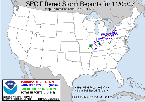
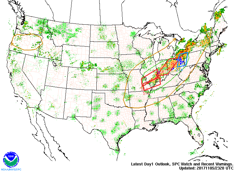
A more zoomed out look at the severe weather reports from November 5 shows that tornadoes and damaging wind also occurred across northwestern Pennsylvania, and severe hail occurred across parts of Missouri and Illinois. Given the large areas that can experience severe weather in a single day, it's not uncommon for several severe thunderstorm and / or tornado watches to be in effect simultaneously. In fact, SPC issued three tornado watches, along with two severe thunderstorm watches on this date, represented by the red and blue parallelograms, respectively on this animation of SPC watches superimposed on radar spanning 23Z on November 5 to 0015Z on November 6. As you can see, SPC covered the area where severe weather occurred quite well!
When severe thunderstorms are occurring, or when radar imagery reveals signs of imminent severe weather, a local forecast office of the National Weather Service will issue a severe thunderstorm warning or tornado warning. What do these warnings mean?
- A severe thunderstorm warning means that forecasters have identified a thunderstorm capable of producing at least one-inch diameter hail or wind gusts of at least 50 knots (58 miles per hour) based on its radar characteristics (or storm spotters are reporting that at least one of these things is occurring). Seek shelter immediately!
- A tornado warning means that forecasters have identified a thunderstorm capable of producing a tornado (possibly in addition to other severe weather) based on its radar characteristics (or based on spotter reports). Seek shelter immediately!
If a severe thunderstorm warning or a tornado warning has been issued for your area, imminent danger to lives and / or property from severe weather may exist currently or very soon. Take shelter and any other necessary precautions immediately!
Severe thunderstorm warnings and tornado warnings are more "urgent" than watches. Warnings also are much smaller than watches, usually spanning about the size of a single county, or maybe portions of several counties, and are also in effect for much shorter time periods (usually about an hour or less). Ideally, warnings are issued far enough in advance to give people in potentially-affected areas enough time to seek shelter and take other safety measures (at least a few minutes before severe weather strikes). Within the tornado watch from November 5, 2017 (shown above), a number of individual tornado warnings were issued, such as the one shown below, for a small area of north-central Ohio. Note the relatively small size of the tornado warning (compared to a watch) in the inset map on the lower left. This particular warning was in effect for just 32 minutes (it was issued at 4:58 PM local time and expired at 5:30 PM local time).
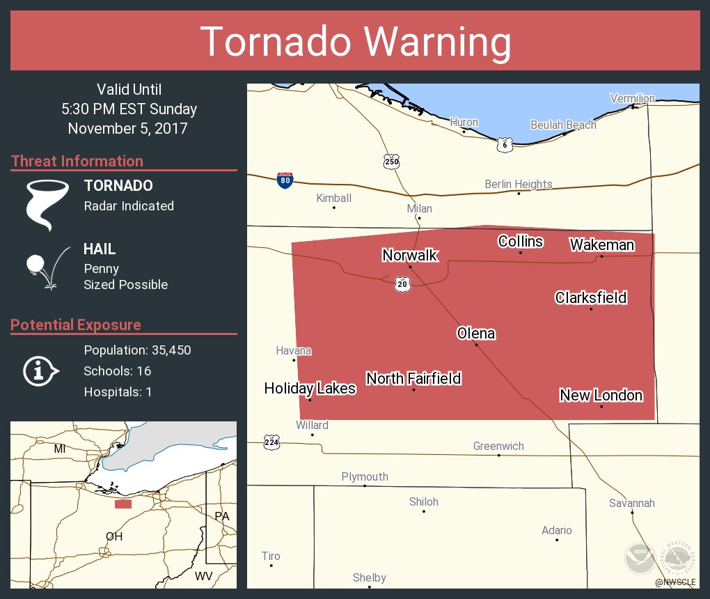
Ultimately, the severe weather (either damaging straight-line winds, large hail, or a tornado) that occurs within a warning area often only affects a small fraction of the area covered by the warning, so a severe thunderstorm warning or tornado warning is not a guarantee that you will personally be impacted by severe weather. A tornado did occur within this particular warning, but its damage path never exceeded 400 yards wide (less than one-quarter of a mile). So, most people in the warning area were not affected by the tornado, which is typical.
Most warnings are issued based on analysis of Doppler radar data, and in the case of tornado warnings, that's a double-edged sword. On the good side, Doppler radar has helped forecasters give earlier advanced warning of tornadoes. Before the Doppler radar era (which began nationwide in the early 1990s), tornado warnings were issued only about three minutes before the actual tornado occurred, on average. But, with Doppler radar's ability to detect rotation within thunderstorms, forecasters can give more advanced warning (10-15 minutes, on average), giving the public more time to seek shelter.
But, not all thunderstorms that exhibit rotation actually form tornadoes (in fact, most don't), and that leads to many "false alarm" tornado warnings (warnings issued in cases where a tornado never occurs). Statistics show that about 75 percent of tornado warnings are actually false alarms. Weather forecasts have improved greatly over the years, but small-scale, fast-changing weather events still provide huge challenges to forecasters, and the precision and accuracy of warnings is an area where there's still lots of room for improvement. The new capabilities of dual-polarization radar (to detect debris from tornadoes) may be able to lower the false-alarm percentage in time, but there's significant concern that the high false-alarm rate will lead to public complacency about tornado warnings. Still, at the end of the day, it's wise to take all warnings seriously and take appropriate precautions immediately. If you prepare and seek shelter and then no severe weather occurs, you're safe (although maybe inconvenienced or annoyed). But, if you ignore the warning and then you're ill-prepared for severe weather that does occur, you may end up injured or dead.
Being able to interpret severe thunderstorm watches and warnings is a critical life skill so that you can identify situations when you may need to take quick actions to seek shelter. I highly recommend having a trusted source of weather information that allows you to get watches and warnings at all times (such as NOAA Weather Radio, or a reliable weather mobile app). Receiving and acting on critical warnings could save your life! Up next, we're going to start looking at the types of thunderstorms that are the most prolific severe weather producers. Read on!