Prioritize...
At the end of this section, you should be familiar with the anatomy of a supercell. Specifically, you should be able to describe the forward-flank downdraft, rear-flank downdraft, updraft region, mesocyclone, and tornado (if applicable). You should also be able to describe the cloud formation (a wall cloud) that's often a precursor to a funnel cloud or tornado formation, and identify the location on radar reflectivity where a tornado might form in a classic supercell.
Read...
We're going to continue with a closer look at supercells since they're such prolific severe weather producers. After all, supercells produce most tornadoes (and nearly all strong tornadoes), are responsible for nearly all reports of hail at least two inches in diameter, and nearly all supercells produce damaging straight-line winds. So, supercells are a triple threat when it comes to severe weather.
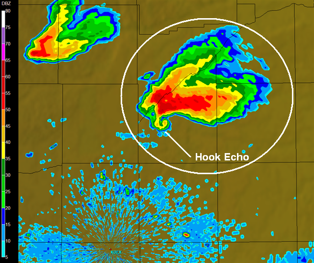
To start, we're going to build off the basic model of a supercell that you learned previously. A classic supercell displays a hook echo on images of radar reflectivity, which occurs as precipitation wraps around the mesocyclone (the rotating updraft), and if a tornado forms, it does so within the hook echo. But, supercells have unique characteristics when it comes to their updrafts and downdrafts compared to other types of thunderstorms, thanks in large part to strong vertical wind shear. Precipitation particles swept upward in the rotating updraft are rapidly carried downstream away from the updraft by strong upper-level winds (air movement within the storm is traced out by tan arrows on the cross-section of a supercell below).
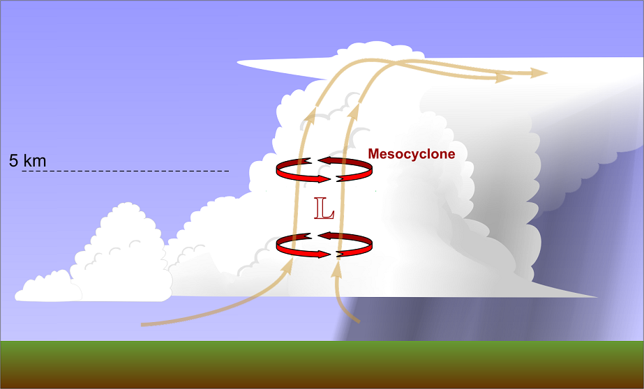
As a result, precipitation particles fall earthward well northeast (or east-northeast) of the updraft typically (note that the highest reflectivity is displaced from the updraft and mesocyclone). This cascade of precipitation particles promotes a downdraft (falling precipitation particles drag air down with them) called the forward-flank downdraft (FFD). Formally, the FFD is the main region of downdraft in the forward (leading) part of a supercell. The FFD is also where most of the heavy precipitation is located within a supercell. Because the precipitation particles have been swept away from the main updraft thanks to strong vertical wind shear, the FFD does not interfere with the updraft, and since updraft and the FFD are separated, the stage is set for supercells to be long-lived.
But, many supercells actually have two distinct areas of precipitation, and therefore, two distinct downdrafts, as demonstrated by this radar cross-section of a supercell (from a supercell near Rapid City, South Dakota on July 13, 2009). In addition to the FFD, there's another downdraft associated with precipitation called the rear-flank downdraft (RFD). How can supercells have two distinct areas of precipitation? Well, some falling precipitation actually gets caught in the mesocyclone's circulation and wraps around to form the hook echo on radar. The RFD develops when dry winds in the middle and upper troposphere (typically southwesterly or westerly) encounter the back side of the updraft, where that precipitation is wrapping around the mesocyclone. The interaction with this dry air promotes evaporation and associated cooling, which, in turn, promotes negative buoyancy and downward accelerations. Some other complex factors (beyond the scope of the course) also contribute to the formation of the RFD, but the bottom line is that a separate rear-flank downdraft exists in supercells. The RFD even comes with its own gust front, as the leading edge of rain-cooled air spreads out laterally from the splashdown point of the RFD.
To help you visualize and locate the various parts of a supercell, including the updraft, mesocyclone, RFD, and FFD, check out the short video "tour" of a supercell below (2:47). In the video, I discuss where these various parts of a supercell appear on idealized radar reflectivity, but also show that not all supercells take on a "classic" look with a hook echo.
We're going to take a short tour of a supercell thunderstorm, starting with the basic pieces you learned about previously. This is idealized radar reflectivity of a classic supercell moving toward the northeast. Air flows into the storm and rises in the updraft region, which coincides with the rotating mesocyclone. Because of vertical wind shear, the precipitation doesn't fall into the updraft, and the storm ends up with separate downdraft regions. Some precipitation wraps around the mesocyclone, forming the hook echo, and if the storm spawns a tornado, it usually forms near the hook echo, near the "T" on this graphic.
Now, let's add some more pieces to our model of a supercell. This idealized image shows radar reflectivity and the cloud outline associated with a classic supercell moving toward the northeast. You can see the storm's inflow traced by these arrows racing in and then ultimately rising in the rotating updraft, but most of the storm's precipitation actually falls on the forward, or leading, flank of the storm. This precipitation forms the forward-flank downdraft, which spreads out at the ground, forming a gust front along its leading edge.
There's another distinct region of precipitation in the storm that forms the rear-flank downdraft, which spreads out along the ground, forming its own gust front. Some of the precipitation in the rear-flank downdraft wraps around the mesocyclone to form the hook echo.
But, not all supercells are this classic. Depending on the upper-level winds, sometimes supercells don't display a hook echo at all. Sometimes, supercells take on more of a pendant shape, where you can see all of the precipitation falling in the forward-flank downdraft, but the rear-flank downdraft isn't very prominent, and contains little or no precipitation. These supercells can still produce a tornado, which would occur near the "T" in the mesocyclone, even though they don't display a hook echo on radar.
On the other hand, if the upper-level winds are just right, sometimes the rear-flank downdraft is really prominent, and contains lots of precipitation. In such cases, there's not an obvious hook echo, and the supercell's radar reflectivity ends up looking more like a kidney bean. Despite the lack of a hook echo, these supercells can still produce a tornado, which would occur again near the "T", although from the ground these tornadoes can be hard to see because they're often masked by precipitation wrapping around them.
So, not all supercells are created equal, which sometimes makes them hard to spot with radar reflectivity. Fortunately, today, meteorologists have Doppler radar with dual polarization capabilities to help them better identify supercells that may be spawning tornadoes.
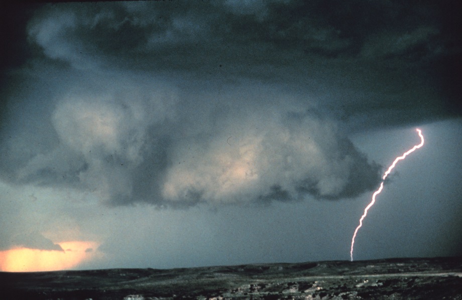
If and when a tornado is going to form, it forms out of the mesocyclone, and sometimes a supercell will give off a visual warning that a tornado may form, even before the appearance of a funnel cloud. The visual clue is called a wall cloud (credit: NOAA Photo Library), which is a local lowering of the cloud base in the mesocyclone. Wall clouds form when air from the forward-flank downdraft region of the storm, which has been cooled via evaporation, gets drawn back into the updraft. Because this air has been cooled by evaporation, its relative humidity is already fairly high, so when it rises into the updraft (and cools further), net condensation occurs more quickly than it does in surrounding air parcels, causing the cloud base to form at a lower altitude (as seen in the schematic below). Occasionally, a "tail cloud" traces the rain-cooled air from the forward-flank downdraft region into the updraft.
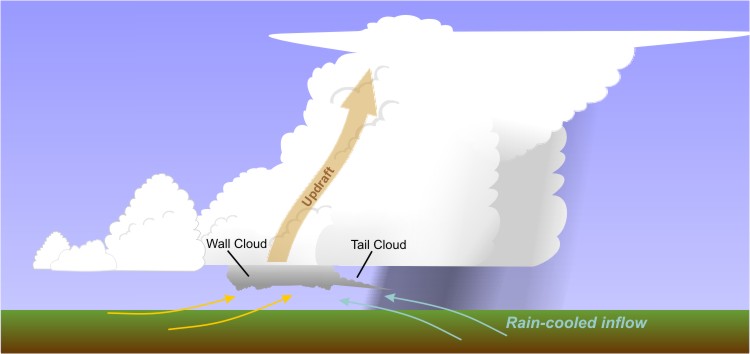
Because the wall cloud is part of a mesocyclone, it often visually displays rotation, and if enough vertical stretching occurs, a funnel cloud may start to descend from the wall cloud. The formation of a wall cloud, however, does not guarantee that a tornado will form, and some tornadoes form without being preceded by a prominent wall cloud. Still, a wall cloud is a visual clue that a supercell might spawn a tornado, and it gives a storm observer on the ground an idea of where a tornado may form in a supercell.
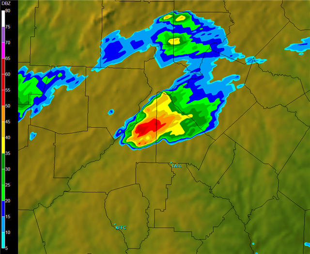
On radar imagery, forecasters look for the classic hook echo to spot the area of a supercell where a tornado may form. But, the presence of a hook echo does not guarantee that a tornado will form. If only it were that simple! To further complicate matters, some tornadoes form in supercells that don't display a hook echo at all. For example, check out the radar reflectivity image from Warner Robbins, Georgia at 0136Z on March 15, 2008 (on the left). This storm doesn't display any obvious hook echo. In fact, there's really nothing about its appearance that clearly indicates it was a supercell. But, it was a supercell that produced a tornado that did damage to the Georgia Dome in Atlanta, while an SEC Tournament basketball game was in progress. Forecasters, fortunately, were able to detect rotation in this storm using Doppler velocities, and issued a timely tornado warning for downtown Atlanta.
Tornadoes certainly challenge weather forecasters because it's not always clear which supercells will produce a tornado and which supercells won't. Tornadoes also challenge public readiness because pinpointing the location where a tornado may form is rarely possible more than 20 or 30 minutes in advance, and sometimes its much less than that! Increasing warning lead time and reducing the number of tornado warnings that are false alarms are certainly major goals in the meteorological community because of the incredible danger and potential for damage associated with tornadoes. Up next, we'll turn our attention to the dangers of tornadoes and cover tips (and myths) about tornado safety. Read on.