Prioritize...
After you've finished this section, you should be able to define hail and describe the process by which hail forms. You should also be able to define graupel, severe hail, and precipitation loading.
Read...
Hail is another thunderstorm hazard that I would consider "underrated." It doesn't tend to make national headlines the way some other weather hazards do, but it's no less damaging. For starters, though, what exactly is hail? Hail is precipitation in the form of balls or chunks of ice produced by convective clouds. Hail is actually the most costly thunderstorm hazard in the United States each year, causing more than a billion dollars per year in damage to vehicles alone! This local news story from 2014 (2:36) about hail damage to 4,300 cars at a dealership in Nebraska demonstrates how the damage to automobiles can be so immense.
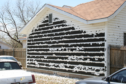
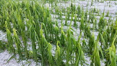
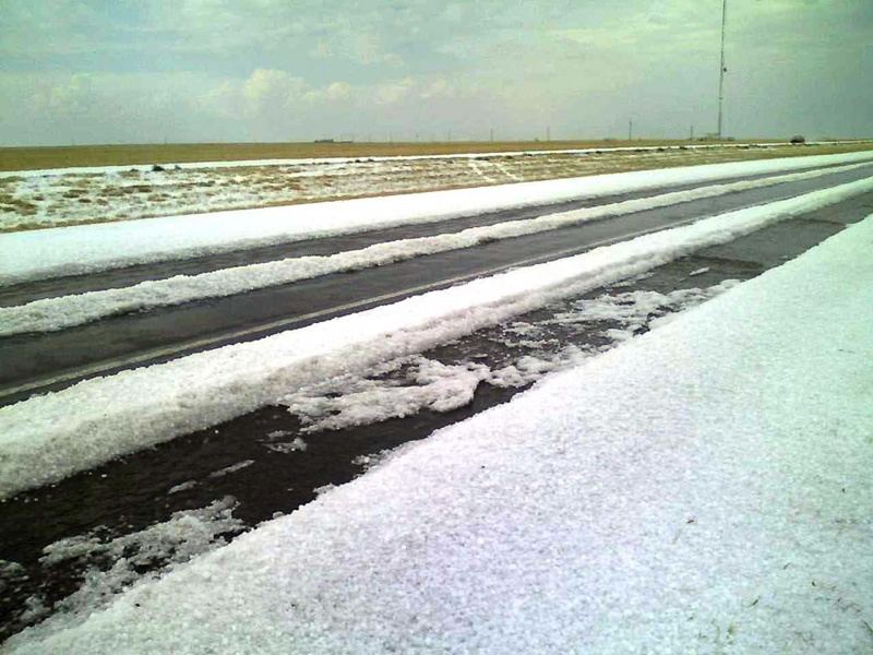
Of course, hail doesn't just damage automobiles. To give you a feel for how hail can brutalize the landscape, check out this amazing video of hail pummeling a backyard in Phoenix, Arizona in 2010 (1:29). After watching the video, perhaps you can see why wind-blown hail can rip the siding right off a building (credit: National Weather Service, Lubbock, Texas) or severely damage crops (credit: National Weather Service, Hastings Nebraska). Note how in the photo of crop damage, hail accumulation somewhat resembles the wake of a snowstorm! Believe it or not, snow plows have been deployed to clean up after significant accumulations of hail (credit: National Severe Storms Laboratory)!
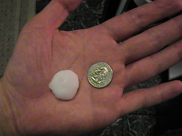
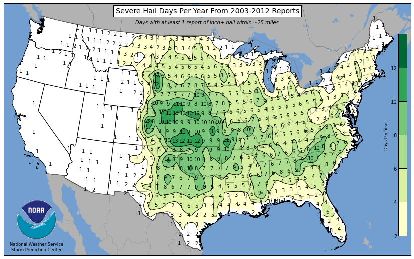
Just about any type of thunderstorm (single cell, multicell, or supercell) can generate hail under the right conditions, but some areas of the United States are more prone to hail than others. The map below shows the average number of severe hail days per year (the average number of days per year with severe hail within 25 miles of a point) from 2003 to 2012. Severe hail is defined as having at least a one-inch diameter (about the size of a quarter; credit: National Weather Service) because research has shown that most damage occurs once hail diameter reaches at least one inch. The map clearly shows that severe hail is much more common from the Rocky Mountains eastward, with the biggest hail "hot spots" being along the Front Range of the Rockies in Colorado and Wyoming and in the central and southern Plains (Oklahoma, Kansas, Missouri, Nebraska, and South Dakota in particular). Hail is also fairly common along the interior of the southeastern U.S. (more than six days per year with one-inch diameter hail).
So, why do some thunderstorms produce hail, while others don't? To answer that question, let's explore how hail forms. For starters, hail formation requires a thunderstorm updraft that's strong enough to prevent growing ice particles from falling for a time. Hailstones actually have a humble and meager beginning, with their roots tracing back to small ice crystals swept up in the main updraft of the storm. Remember that high up within cumulonimbus clouds, the cloud is actually composed of some ice crystals, but also many supercooled water drops (water in liquid form that is less than 32 degrees Fahrenheit). After a relatively short period of time (on the order of ten minutes), ice crystals grow to the point that they have sufficient mass causing them to settle with respect to the lighter cloud drops.
At this point, growth quickens as ice crystals "collect" supercooled cloud drops and raindrops, which freeze on contact (a collection process called "accretion"), forming graupel. The formation of graupel paves the way for rapid growth as these heavier snow pellets sweep out more and more supercooled droplets (frozen raindrops can also serve as hail embryo). As the rate of growth accelerates, supercooled drops may not freeze immediately after contact. Instead, they spread over the hailstone like a film, filling in gaps between places where supercooled drops previously froze, which increases the density of the hailstones.
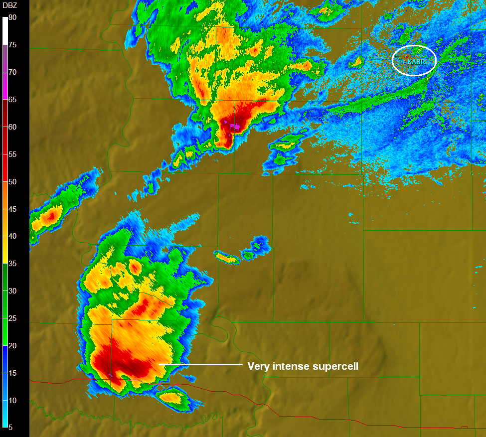
In general, updraft speeds of at least 10 to 15 meters per second (more than 20 miles per hour) are required for hailstones to develop. Hailstones grow largest when their fall speeds match the velocity of the updraft in regions where there's a large supply of liquid drops in the cloud. In such a scenario, suspended hailstones eagerly gobble up supercooled drops, achieving diameters as large as four inches (about the size of a softball) when updraft speeds are very strong (50 meters per second or faster). So, strong updrafts are required in order to suspend large volumes of hail and liquid drops high in a thunderstorm, a process which is called precipitation loading. Hailstones have very high radar reflectivity, and meteorologists can spot the signs of precipitation loading using cross-sections of radar reflectivity by locating areas of very high reflectivity aloft in a thunderstorm (altitude in thousands of feet is marked along the left of the image).
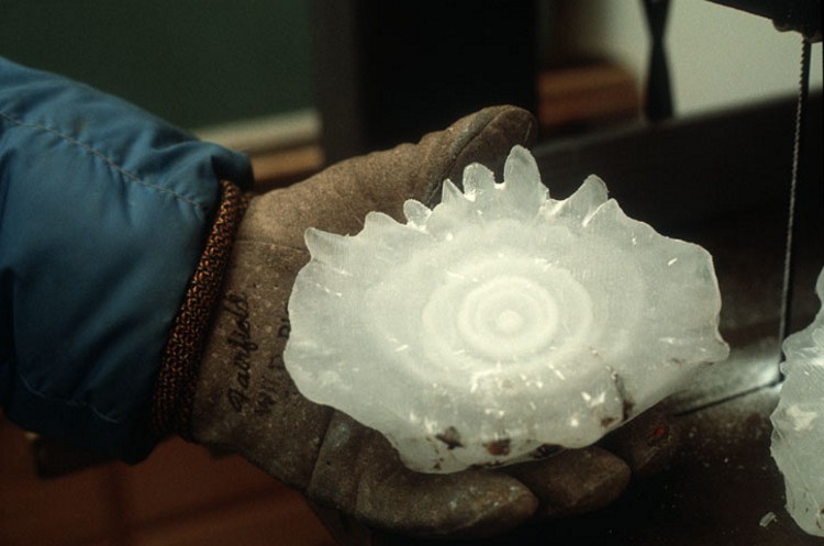
As hailstones suspended by strong updrafts get larger, they develop onion-like patterns of ice as they get tossed about by the turbulent updraft (see the cross-section of the hailstone below). Layers alternate between clear, hard ice that forms in environments with lots of liquid water drops (water spreads across the hailstone before freezing) and softer, milky ice that forms in environments with fewer liquid drops available (water freezes on contact, trapping tiny air bubbles in the process). I also note that hailstones are generally spherical or oblong, but hailstones can also clump together, resulting in a spiky appearance.
When thunderstorm updraft speeds get pretty fast (greater than 35 meters per second) and hailstones are still fairly small, some hailstones can get ejected from the updraft, depriving them of further meaningful growth (because they're no longer suspended in the updraft). Hailstones suspended in the updraft, however, continue to grow as the "rejects" (hailstones tossed out of the updraft) start falling toward the ground, which contributes to a variation in the sizes of hailstones that we observe at the ground. The sizes of hailstones that we eventually observe at the earth's surface (or whether hailstones survive to the surface at all) also depends on the altitude of the melting level. As hailstones fall toward the ground, eventually their environment becomes warm enough that they start melting, and it becomes a race to see whether the hailstones can survive to the ground before entirely melting into liquid.
So, thunderstorms that produce hail require strong updrafts, and typically, strong updrafts require very warm, buoyant air near the ground. But, the warm air in the lower troposphere can't be too warm, or extend up too high, or else hailstones will melt completely before hitting the ground. A complicating factor is that, as hail tumbles to the ground, evaporation of nearby raindrops occurs, which cools the air (evaporational cooling) and slows the melting process somewhat. So, meteorologists have to account for evaporational cooling, too, as they try to determine whether it's likely that hail will be able to survive to the ground before melting. The details of hail forecasting can be tricky indeed!
With regard to forecasting specific sizes of hail (say, 2.5 inches in diameter versus 3.5 inches, for example), I won't beat around the bush. In a nutshell, forecasting specific hail size is practically Mission Impossible because of the complex processes and updraft interaction that hail size depends on (processes which we can't regularly observe, for all practical purposes). Recently, some new methods have been developed to predict hail size based on a comparison of existing environmental conditions to historic severe hail cases, but the predictions take the form of a "best guess" for maximum possible hail size (sort of a "reasonable worst case scenario" for what a storm might produce).
Still, meteorologists are usually able to recognize the atmospheric conditions which may favor severe hail. Meteorologists look for environments that favor strong thunderstorm updrafts and have relatively thin "warm" layers extending up from the surface to limit melting. If the melting layer extends any more than about 11,000 feet above the ground, typically hailstones can't survive their descent to the surface. Analyzing these factors helps meteorologists alert the public to the risk of large hail with certain thunderstorms, even if we can't reliably pinpoint exactly how large hail might be. Hail prediction is pretty complex, and is certainly an active area of current research!
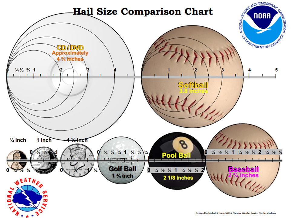
In weather reports, hail size is usually compared to common objects to give the public an idea of just how big hailstones are (see the chart below). So, that's why you may hear meteorologists refer to "golf-ball sized hail" (1.75 inches in diameter) or "softball-sized hail" (four inches in diameter), for example. Hail greater than two inches occurs almost exclusively in supercell thunderstorms, as you may recall, and on rare occasions, supercells can produce gigantic hail. The largest hailstone on record in the U.S. occurred with a supercell in Vivian, South Dakota on July 23, 2010, measuring a diameter of a whopping eight inches (credit: National Weather Service), which is about the size of a volleyball. That'll leave a mark!
In case you're wondering, hail storms can be deadly, although death-by-hail is relatively rare (averaging less than one death per year in the United States). The deadliest hailstorm in modern times likely occurred in India in 1888 (246 people were killed). Needless to say, you don't want to be outside when hailstones plummet to the ground!
Now that we've covered "precipitation" hazards associated with thunderstorms (flash flooding and hail), we'll turn our attention to a hazard that is somewhat related to precipitation. As precipitation falls to the ground in the downdraft of a thunderstorm, sometimes the downdraft can become quite strong and pave the way for damaging winds. We'll explore that in the next section!