Prioritize...
After completing this section, you should be able to describe waterspouts and landspouts, dust devils, fire whirls, and gustnadoes, and discuss the dangers they pose.
Read...
While supercells spawn the vast majority of tornadoes, they aren't the cause of all tornadoes. In this section, I'm going to briefly summarize a handful of other whirlwinds, some of which are formally classified as tornadoes and some of which aren't. As you'll see, most of them have some common characteristics, namely that they tend to form in environments with horizontal wind shear (a horizontal change in wind direction or speed) that induces some spin and where the low-level air is very warm and buoyant (to favor vertical stretching of the air column).
Waterspouts and Landspouts
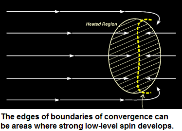
Waterspouts are basically tornadoes over water, and there are essentially two types. The first type is a regular tornado that occurs with a severe (supercell) thunderstorm over the water (these are called "tornadic waterspouts"). The second type of waterspout (usually called a "fair-weather waterspout") forms a bit differently. They're called "fair-weather" waterspouts because they typically form beneath cumulus or cumulus congestus clouds (not full-blown thunderstorm clouds). Fair-weather waterspouts often owe their development to uneven heating of land and water surfaces, because uneven heating results in boundaries where low-level air converges, and the edges of such boundaries can be areas ripe for creating low-level spin.
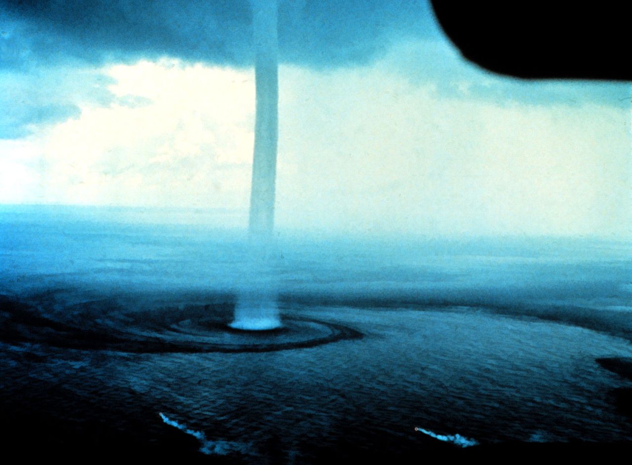
Fair-weather waterspouts tend to form in humid air masses over very warm water. When the environment becomes very unstable, and a circulation develops along any boundary of low-level convergence, the strong positive buoyancy of air parcels can lead to vertical stretching and the development of a waterspout from the ground up. Because of the importance of warm water, the shallow waters near the Florida Keys are a prime area for waterspouts (hundreds of waterspouts form per year in this area), with the peak months being August and September because that's when the waters are warmest. Waterspouts can also form on smaller bodies of water, like the Great Lakes, when cool air masses flow over the relatively warm lake waters in late summer and early fall. The photograph below, for example, shows a family of four waterspouts that formed on Lake Huron on September 9, 1999.
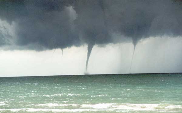
Fair-weather waterspouts can be visually stunning (credit: NOAA Library), but the winds in fair-weather waterspouts typically don't exceed about 70 miles per hour (on par with an EF-0 tornado). Still, such waterspouts are a hazard to boaters. Indeed, fair-weather waterspouts can capsize boats, so boaters should keep their distance from waterspouts (or perhaps refrain from going out on the water if waterspouts are likely). Waterspouts can also occasionally come onshore and cause minor damage (although there's greater potential for damage if a tornadic waterspout that forms from a supercell moves onshore).
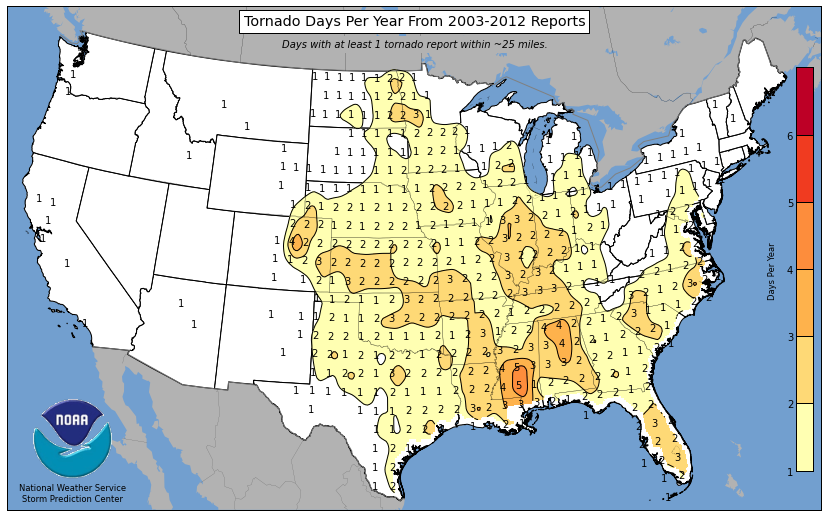
I should also add that waterspouts have a continental cousin, called a landspout. Landspouts form in a similar fashion to waterspouts. First, a low-level circulation forms along a boundary of converging air before any deep convective clouds develop. Second, a growing cumulus cloud sprouts over the pre-existing spin and the circulation builds upward in concert with buoyant, rising air. The associated vertical stretching of the air column then paves the way for a tornado (landspout) to form. A zone just east of Denver, Colorado is naturally ripe for landspout formation because air flowing over the local rugged terrain can lead to the low-level convergence and circulation needed for landspout formation. The frequency of landspouts in eastern Colorado is evident on the map showing the average number of tornado days per year from 2003 - 2012. Note that the area with three to four tornado days per year in eastern Colorado has more tornado days per year (on average) than most of tornado alley, and it's largely because of landspouts!
Dust Devils
A dust devil is a rotating column of air near the ground that kicks up lots of dust and dirt. Dust devils are not formally classified as tornadoes because they do not connect to a cloud base, although intense dust devils can look kind of like tornadoes from the ground, as evidenced by this amazing video of a dust devil invading a soccer game in Bolivia in 2021. Dust devils are short-lived (lasting a few minutes or less), and are usually harmless (although I'm not sure I'd run through one like the kids in the video). Dust devils only rarely cause minor damage, as their peak winds speeds are usually less than 50 miles per hour, but on rare occasion they can reach the intensity of an EF-0 tornado.
Dust devils form on hot, sunny days over dry landscapes. Solar heating promotes strong positive buoyancy and rising currents or air near the ground, and the wind's interaction with terrain (hills or mountains), or even buildings or moving vehicles can impart some spin on the air. If you've ever seen a whirl of leaves kick up as the wind blows past the corner of a building, you've seen the mechanism that can help create a dust devil. Since they're so small and short-lived, dust devils can rotate either clockwise or counterclockwise in the Northern Hemisphere, depending on the direction of the spin induced by horizontal wind shear (the Coriolis Force does not have a noticeable effect). That's in contrast to real tornadoes; almost all real tornadoes rotate counterclockwise in the Northern Hemisphere (but there are a few rogue ones that rotate clockwise).
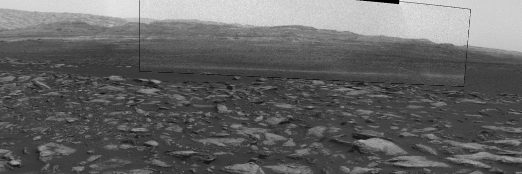
I should also note that dust devils aren't purely an earthly phenomenon. Indeed, the Curiosity Mars Rover has captured dust devils traversing the Martian landscape, like the one captured above on February 1, 2017. To my knowledge, there is no footage of Martian children running through a dust devil, however. :-)
Fire Whirls
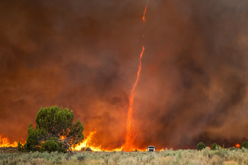
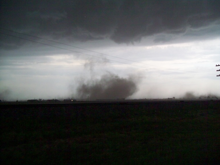
A fire whirl is essentially a tornado of fire that can form in a wildfire. Fire whirls form because of temperature contrasts between the fire itself and its cooler surroundings (which haven't been burned yet). The resulting temperature gradients can be very large and create large pressure gradients, complete with small areas of low pressure that form over the hottest spots in the fire. In response, air swirls in and blows strongly around the wildfire, which can actually cause the fire to spread by increasing its oxygen supply, fanning the flames, and tossing burning embers around. If updrafts of rising air are strong enough within the hot fire as air swirls inward, a tornado of fire can spin up (check out the photo on the right). Fire whirls are very dangerous to firefighters and make the fire more difficult to battle.
Gustnadoes
Sometimes along gust fronts, small, transient whirlwinds, called gustnadoes (a mash-up of gust front and tornadoes), can spin up. Storm chasers typically detect gustnadoes when they kick up dust in open areas (credit: Rick McCoy via the National Weather Service). Even though they can cause damage (the gustnado in the linked photograph knocked down several trees and broke a car window in Van Wert, Ohio on June 6, 2008), meteorologists do not classify gustnadoes as tornadoes because gustnadoes do not connect to a cloud base, and they are typically so short-lived that there would be little benefit in the National Weather Service issuing tornado warnings. If we considered gustnadoes to be true tornadoes, virtually all supercells would then be tornadic because gustnadoes almost always spin up along their gust fronts. Thus, forecasters would have to issue tornado warnings for practically every supercell that erupts, even though the gustnadoes it spawns would come and go in very short periods of time (likely before people could act on a warning) and sometimes cause little, if any, damage.
There's no doubt that the weather hazards associated with thunderstorms are numerous. From flash floods, to hail, to a variety of wind-related hazards, it's important to be on your toes when severe thunderstorms are in the forecast! I hope the information in this lesson helps you be more aware of the risks of severe weather and can help you prepare and stay safe should you encounter severe weather in the future.