Prioritize...
After reading this section, you should be able to describe how clouds and water vapor affect temperatures and diurnal (daily) temperature ranges.
Read...
In addition to the temperature controllers we've already covered, some other important factors act as temperature controllers, too. I'll start this section with a temperature controller we've already talked quite a bit about -- clouds. It's a good chance to review some concepts you've already learned, and tie things together.
Clouds
Clouds alter temperatures by both absorbing and scattering incoming solar radiation and by emitting infrared radiation. The net impact of this, as you should recall, is that all else being equal, a cloudy day is cooler than a sunny day, because clouds back-scatter much more solar radiation to space than the amount of infrared radiation that they emit toward the ground. At night, with solar radiation out of the picture, the emission of infrared radiation by clouds keeps the ground warmer than it would be on a clear night, so clouds act like space heaters (clouds emit more infrared radiation than a clear sky).
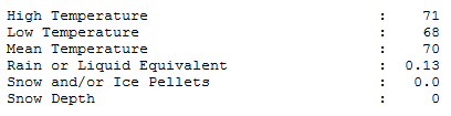
To see a quick example of this in action, check out the official daily observations from Penn State University on July 6, 2017. The day's high was 71 degrees Fahrenheit, while the day's low was 68 degrees Fahrenheit. That's only a three-degree diurnal range in temperature, which is really remarkable for July, in the midst of summer when solar heating is near maximum. In fact, it's one of the smallest diurnal temperature ranges on record for July at Penn State (records date back to 1893)!
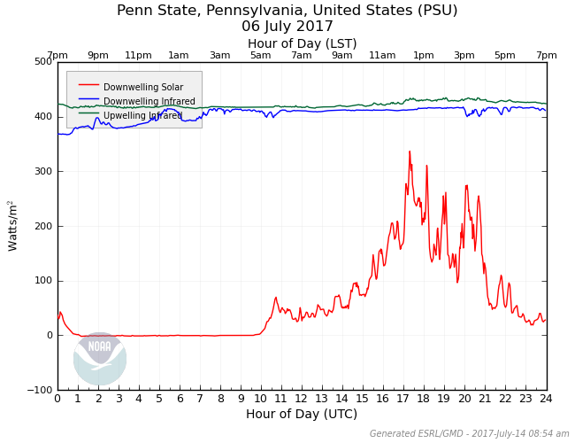
Clouds were so persistent and thick throughout the day that the ground was absorbing less solar radiation than downwelling infrared radiation from clouds and air molecules (check out the surface radiation plot below). Still, the additional downwelling infrared didn't make up for the huge reduction in downwelling solar radiation, which helped limit the daytime high to just 71 degrees Fahrenheit (which is below normal for July).
With no solar radiation to block at night, clouds took on their "space-heater" role, emitting infrared radiation toward the ground, and keeping nighttime temperatures higher than if skies had been clear. The end result? Temperatures only fell a few degrees, to a low of 68 degrees Fahrenheit.
I should point out that some other factors contributed to the small diurnal temperature range on July 6, 2017 at Penn State, but clouds were a major one. Even when clouds aren't present, however, invisible water vapor acts as a temperature controller, especially at night.
Dew Points and Nighttime Low Temperatures
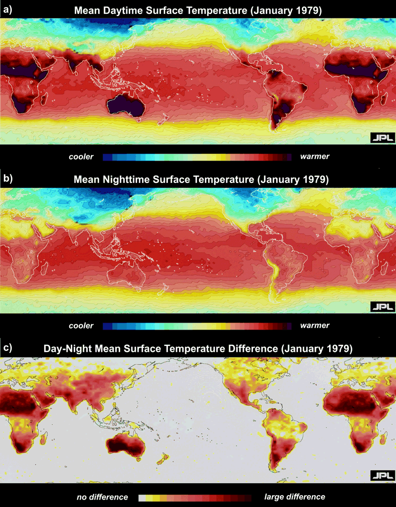
On sultry, very humid nights during the summer, lows in the 70s are common. However, in arid, desert regions, nighttime temperatures can fall considerably. For example, during the Gulf War in 1991-92, the military endured searing desert heat by day. Away from the tropical Persian Gulf, dew points were mercifully low, setting the stage for hot days to be followed by nights so chilly that soldiers needed blankets to stay warm. For further proof, check out the Sahara Desert in northern Africa in the global average temperatures for January, 1979 (below). Note that the Sahara is hot during the day (top map) and cool at night (middle map), making this desert and others the areas of the world with the greatest diurnal change (lower map).
Why do the largest diurnal temperature ranges occur in desert regions? For starters, frequently cloud-free skies during the day make for maximum solar heating and blazing hot afternoons. Furthermore, dry continental-Tropical (cT) air masses with low dew points allow for major cooling at night. For one example in the United States, El Paso, Texas frequently finds itself within cT air masses, and daytime highs near 90 degrees Fahrenheit are sometimes followed by nights with temperatures near 50 degrees Fahrenheit.
Why do lower dew points favor significant cooling at night? On the flip side, why do higher dew points favor warmer nights? Recall that dew point temperature is a way to assess the concentration of water vapor present, so low dew points equate to low concentrations of water vapor and high dew points equate to high concentrations of water vapor. To see how dew points affect nighttime temperatures, let's simplify things and assume the wind is calm, and the sky is clear.
On a night with high dew points, ample water vapor emits infrared radiation to the readily absorbing ground (remember that water vapor is the most prominent greenhouse gas), helping to slow its cooling rate. In turn, the ground, radiating at an elevated temperature courtesy of water vapor emissions, now provides a boost in infrared energy for water vapor to absorb and warm up. This radiative synergy between the ground and water vapor keeps the ground and the overlying air warmer at night, resulting in elevated nighttime temperatures. If you've ever spent time in the Southeast U.S. during summer, you've experienced this effect first hand. Temperatures during the day frequently reach 90 degrees or more in warm, moist, maritime-Tropical (mT) air masses, but high dew points (high concentrations of water vapor) often help keep nighttime lows in the 70s (even with clear skies and calm winds).
On nights with relatively low dew points (like you could find in a cT air mass, for example), reduced concentrations of water vapor limit the amount of infrared radiation that the ground receives from the atmosphere. Like you would expect when reducing a source of income, the ground's energy budget will run a much larger radiation deficit than when dew points are high. The result is that temperatures can fall like a rock toward the dew point. Indeed, on clear, relatively calm nights, the dew point serves as a reasonable lower bound for the nighttime minimum temperature (air temperatures do not measurably fall below the dew point temperature, for reasons we'll discuss later).
So, water (in the form of clouds or invisible water vapor) certainly impacts temperature. What about if we have precipitation? We'll tackle that in the next section, and we'll check out the impacts of varying ground cover (namely snow cover and urban versus rural landscapes). Read on!