Sea Level: Measurement and Recent Trends
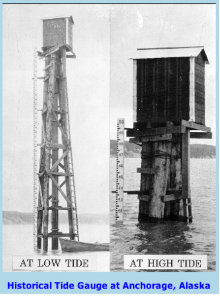
Sea level is rising at present and this rise provides some important insight into recent climate change — a warmer planet means the transfer of glacial ice to the oceans, and warming of the oceans causes an expansion of seawater. There are two main ways to directly measure recent changes in sea level — tide gauges and satellites. Tide gauges are fairly simple devices that record the height of sea level at a particular spot; the records are dominated by the daily tides (see photo below), but the data can be used to estimate the average sea level height each year.
Tide Gauges
Tide gauges measure the height of sea level relative to the ground, and if the ground is stable, then they may be recording a global sea level change; if the ground is unstable, then the tide gauge record is difficult to interpret. Sites that are near the boundaries of tectonic plates are geologically unstable, so their tide gauge records are not reliable. Other sites located near the locations of formerly large ice sheets are also unstable in the sense that the land there is rising due to the removal of the ice from the last glacial age. This ice weighed a great deal (it was around 5 km thick) and its removal has triggered a very slow, steady rise of the crust — it’s like pushing down on a block of wood floating in the water and then removing your hand — the block rises up. Extending this analogy to the Earth, the block of wood is the crust and the water is the mantle, which is a very, very sluggish fluid, thus the crust does not spring up quickly, but takes several tens of thousands of years. If the land is rising up, then it would appear that sea level is falling, and indeed, this is seen in many tide gauge records from polar regions.
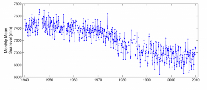
The scatter plot shows monthly mean sea level data in millimeters from 1940 to 2010. The y-axis represents sea level in millimeters, ranging from 6600 to 7800 mm, while the x-axis shows years from 1940 to 2010. The data points, plotted as blue dots, exhibit significant variability but reveal a general downward trend over the 70-year period, starting around 7400 mm in 1940 and decreasing to approximately 6700 mm by 2010.
- Graph Overview
- Title: Implied as Monthly Mean Sea Level (not explicitly stated)
- Type: Scatter plot
- Time Period: 1940 to 2010
- Axes
- Y-axis: Monthly mean sea level (6600 to 7800 mm)
- X-axis: Year (1940 to 2010)
- Data Points
- Representation: Blue dots
- Trend: General downward trend
- 1940: Around 7400 mm
- 2010: Around 6700 mm
- Variability
- Description: Significant fluctuations throughout the period
This tide gauge record comes from Churchill, Ontario (Canada), on the edge of Hudson’s Bay; here, you can easily see the downward trend, meaning that sea level appears to be falling, but this is just in a relative sense. The story here is that the crust is rising, so sea level appears to be falling. The crust is rising in response to the melting of an ice sheet about 5 km thick that was present during the last ice age.
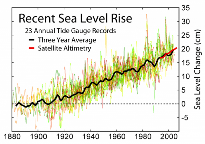
Because of the problem of crustal stability, tide gauge records have to be selected very carefully if we want to learn something about how global sea level is changing. Not surprisingly, this work has been done (Douglas, 1997), and a set of 23 tide gauge records have been selected, shown in the figure below.
Satellites
The satellite data are interesting to consider — how can a satellite measure sea level changes? The answer is surprisingly simple at one level — it just measures the distance from the satellite to the sea level surface. The figure below shows how the system works, using a radar beam that bounces off the water surface and returns to the satellite. The height of sea level is actually the difference between the distance between the satellite and the sea surface and something called the reference ellipsoid, which is a kind of smoothed approximation of the Earth’s shape.
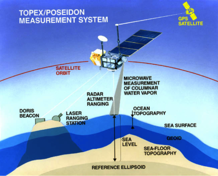
The diagram illustrates how the TOPEX/Poseidon satellite measures ocean characteristics. The satellite, in orbit, uses a radar altimeter for ranging, a microwave measurement system for water vapor in the column, and communicates with a GPS satellite for positioning. It also interacts with a DORIS beacon and a laser ranging station on the ground. The diagram shows the sea surface, sea level, geoid, sea-floor topography, and a reference ellipsoid, with arrows indicating the measurement paths from the satellite to the ocean and ground stations.
- Diagram Overview
- Title: TOPEX/Poseidon Measurement System
- Type: Illustrative diagram of satellite measurement
- Satellite Components
- Satellite: TOPEX/Poseidon
- Position: In orbit
- Features: Radar altimeter, microwave measurement system
- GPS Satellite: Assists with positioning
- Satellite: TOPEX/Poseidon
- Measurement Methods
- Radar Altimeter Ranging: Measures distance to sea surface
- Microwave Measurement: Assesses water vapor column
- Laser Ranging Station: Ground-based, interacts with satellite
- DORIS Beacon: Ground-based, supports satellite positioning
- Ocean Features
- Sea Surface: Top layer
- Sea Level: Average height
- Geoid: Gravitational surface
- Sea-Floor Topography: Ocean floor structure
- Reference Ellipsoid: Baseline for measurements
- Visual Elements
- Arrows: Indicate measurement paths
- Colors: Blue for ocean, beige for land, gray for stations
The satellite is orbiting the Earth at a height of around 1300 km and can cover the surface of the oceans in 10 days, making several hundreds of thousands of measurements during that time, and keeping very close track of where it is located relative to some control points on the Earth. As a result, this system can measure the mean sea level to within a few millimeters — quite a remarkable achievement.
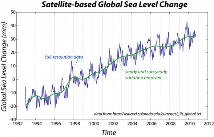
These observations show that sea level is undoubtedly rising, but in a somewhat irregular pattern, and lead us to ask why. What is causing this rise in sea level? There are two main explanations for this rise. One is a simple expansion of seawater as it warms and becomes less salty — this is known as the steric effect. As seawater expands, it takes up a greater volume, and so the sea surface elevations rises. If the sea water warms by 1 °C, the steric sea level rise would be about 7 cm. An additional small increase comes from a slight freshening of the oceans — salty water is denser than fresh water. This steric effect is believed to account for the majority of the observed sea level rise. The other main reason for sea level rise is from the melting of glaciers, which transfers water previously stored above sea level back to the oceans. As we have seen, mountain glaciers around the globe are melting and so are the big ice sheets of Greenland and Antarctica.
The effect of warming and freshening of the oceans is believed to be behind the annual cycle seen in the above satellite data. As you might expect, the warming and freshening do not occur uniformly across the globe, so the global pattern of sea level rise and fall is somewhat complicated, and this goes a long way toward helping us understand why the tide gauge records (from the “stable” sites) show considerable variations.
Other Indicators
Looking further back, we must rely on the geologic record. Benthic foraminiferal species that live in marshes have narrow depth ranges. Foraminifera found in cores of tidal marsh sediments can yield the depth at which they live and dated to provide an age. In this way, geologists have determined changes in sea level of the North Carolina coastal zone back to 0 AD, before tidal gauges were employed. The curve shows a sharp increase in the rate of sea level rise in the middle of the 19th century, coincident with the Industrial Revolution.
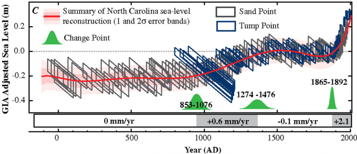
The graph plots GIA-adjusted sea level in meters on the y-axis (-0.4 to 0.2 m) against years AD on the x-axis (0 to 2000). The graph includes data from Sand Point (gray) and Tump Point (blue) with error bands. It shows three distinct periods: a stable sea level from 0 to 855 AD (0 mm/yr), a slight rise from 855 to 1274 AD (+0.6 mm/yr), a stable period from 1274 to 1865 AD (-0.1 mm/yr), and a sharp increase from 1865 to 1892 AD (+2.1 mm/yr). Green change point indicators mark transitions at 855-1076 AD, 1274-1476 AD, and 1865-1892 AD.
- Graph Overview
- Title: Summary of North Carolina sea-level reconstruction (1 and 2σ error bands)
- Label: C
- Type: Line graph with error bands
- Time Period: 0 to 2000 AD
- Axes
- Y-axis: GIA-adjusted sea level (-0.4 to 0.2 m)
- X-axis: Year AD (0 to 2000)
- Data Sources
- Sand Point: Gray error bands
- Tump Point: Blue error bands
- Periods of Sea Level Change
- 0-855 AD: Stable (0 mm/yr)
- 855-1274 AD: Slight rise (+0.6 mm/yr)
- 1274-1865 AD: Stable (-0.1 mm/yr)
- 1865-1892 AD: Sharp increase (+2.1 mm/yr)
- Change Points
- 855-1076 AD: Transition to rising sea level
- 1274-1476 AD: Transition to stable sea level
- 1865-1892 AD: Transition to sharp increase
- Visual: Green peaks indicating change points
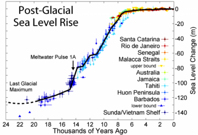
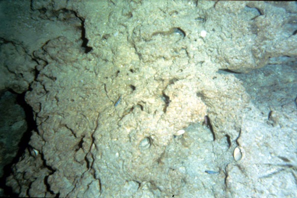
Corals provide a reliable way to determine sea level in the past since they grow within about 5 meters of the sea surface (see Module 7). If we find a coral submerged at 200 meters (see below), then sea level must have been 195-205 meters below current levels. In this way, sea level for the last 22 thousand years has been developed using the depths of corals, dated using carbon-14 or uranium isotopes, below current sea level.
Drowned Coral
Besides coral, there are other indications of sea level rise. Fjords are drowned glacial valleys, and estuaries, such as the Chesapeake Bay, are drowned river valleys. Both of these morphological features indicate that sea level has risen recently.
Sea Level Rise
We can see that sea level changes much more dramatically on the timescale of the ice ages. The last ice age peaked around 20,000 years (20 kyr) ago, and at that time, a great deal of water from the oceans was locked away in large ice sheets, so sea level was about 120 m lower than it is today! This is a colossal change and it would have dramatically changed the coastlines of the world. It is interesting to consider the rate of sea level change associated with this transition out of the last ice age. Sea level rose by about 120 meters in about 10 kyr, giving us a rate of 12 mm/yr, which is about four times faster than the average rate of sea level rise today.
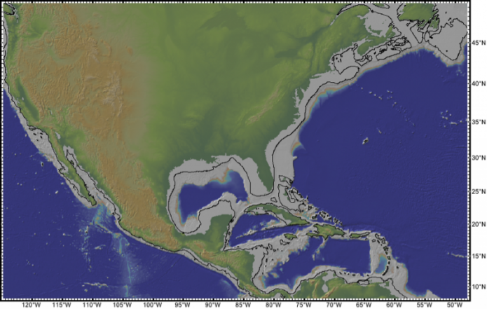
Imagine what the world looked like 20,000 years ago when sea level was so much lower. To help, look at the figure below, which shows the elevation both above and below current sea level. The modern shoreline is easy to see — it is where the green colors begin. The black line offshore shows about where the shoreline was when sea level was 120 meters lower than today.
Now, more realistically, let's imagine what will happen to the coastal zone in coming centuries if sea level rise accelerates. We will observe flood maps in the following lab.

