
Ancient Sea Level: Concept of World Without Ice
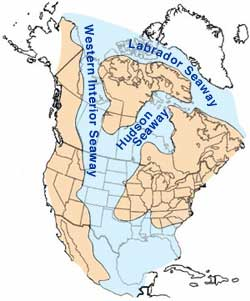
We have been there before. There is plentiful evidence that the sea flooded the interior of continents multiple times in Earth history. These marine incursions alternated with times when the ocean receded to below the level of the current continental shelf. The sedimentary rocks that are found in the interiors of continents contain the fossilized remains of marine organisms such as clams, oysters, and corals, demonstrating that they were deposited below the sea. Geologists have known about these continent-scale sea level fluctuations for a long time. In the 1950s and 1960s, the brilliant geologist Larry Sloss of Northwestern University mapped out marine units across from one side of North America to the other and showed that they lasted many millions of years.
We now know that some of the highest sea levels took place at times when the climate was warm and there were no ice sheets covering the poles. Likewise, times when global sea level very low corresponded to cold intervals when the ice sheets were extensive. As we established in Module 5, one of the main drivers of climate during these times was the amount of CO2 in the atmosphere.
One period with high CO2 levels, the late part of the Cretaceous about 90 million years ago, was a time when the high latitudes were too balmy to maintain ice sheets. There is much evidence for late Cretaceous warmth, none less compelling than the discovery of fossils of palm trees and reptiles in northerly places such as Alaska and Ellesmere Island in northern Canada. Beginning in the late Eocene (about 40 million years ago) ice began to accumulate on Antarctica and in the late Pliocene (about 3 million years ago) the northern hemisphere ice sheets began to grow. These changes in the psychrosphere (the technical name for the major ice sheets) led to substantial changes in sea level. In fact, some estimates of sea level in the middle Cretaceous are 170 meters higher than at present and those in the Eocene are 100-150 meters higher (see curve below).
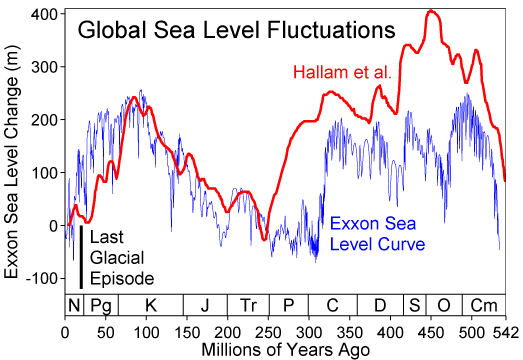
The graph shows sea level changes in meters on the y-axis (-150 to 400 m) over millions of years ago on the x-axis (0 to 542 million years). The graph features two data sets: a red line labeled "Hallam et al." and a blue line labeled "Exxon Sea Level Curve." Both lines fluctuate significantly, indicating sea level rises and falls across geological periods marked on the x-axis: Neogene (N), Paleogene (Pg), Cretaceous (K), Jurassic (J), Triassic (Tr), Permian (P), Carboniferous (C), Devonian (D), Silurian (S), Ordovician (O), and Cambrian (Cm). A notable drop occurs during the Last Glacial period, around 0-50 million years ago, with sea levels falling to around -100 m.
- Graph Overview
- Title: Global Sea Level Fluctuations
- Type: Line graph
- Time Period: 0 to 542 million years ago
- Axes
- Y-axis: Sea level change (-150 to 400 m)
- X-axis: Millions of years ago (0 to 542)
- Data Sets
- Hallam et al.: Red line
- Exxon Sea Level Curve: Blue line
- Geological Periods
- Neogene (N), Paleogene (Pg), Cretaceous (K), Jurassic (J), Triassic (Tr), Permian (P), Carboniferous (C), Devonian (D), Silurian (S), Ordovician (O), Cambrian (Cm)
- Key Event
- Last Glacial: Around 0-50 million years ago
- Sea Level: Drops to around -100 m
- Last Glacial: Around 0-50 million years ago
- Trend
- Description: Both lines show significant fluctuations, with peaks and troughs across periods
We have seen that if we melt all the ice on the Antarctic and Greenland ice sheets, that sea level will rise by about 70 meters. So how come sea level in the Cretaceous and Eocene was almost double this amount higher than at present?
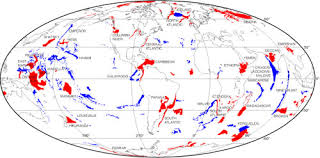
The answer to this question is not just a climatic one. The Cretaceous, in particular, was a time of very active volcanism. Thick deposits of volcanic ash are found in Cretaceous marine sediment sequences, suggesting some gargantuan volcanic eruptions. Moreover, there is substantial evidence that volcanic activity was also more intense in the ocean basins themselves. Numerous large plateaus, known as large igneous provinces, or LIPS for short, date back to the Cretaceous. One of these, the Ontong Java Plateau in the western Pacific, is an area as large as Alaska and up to 30 km thick. In total, the Ontong Java eruptions lasted a few millions of years and spewed out 100 million cubic kilometers of lava. The period from 125 to 90 million years ago was characterized by very active volcanism. In addition to the Ontong Java Plateau, there are numerous other LIPS in the Pacific and Indian Oceans, as well as the Caribbean. In fact, much of the western part of the Pacific Ocean is characterized by a topographically elevated crust of Cretaceous age, known as the Darwin Rise, that was produced during times of very active volcanism. The Darwin rise is peppered with volcanic islands and seamounts.
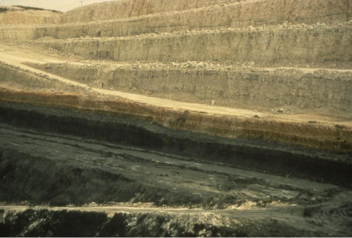
There is evidence that the largest of the LIP eruptions including the Ontong Java Plateau and the Caribbean involved the outgassing of so much CO2 that they caused abrupt global warming events somewhat similar to the PETM. Because the ocean was already quite warm at these times, and warm water can hold less oxygen than cold water (as we saw in the section on hypoxia in Module 6), the Cretaceous LIP eruptions are thought to have triggered ocean wide hypoxic or anoxic events that led to the deposition of sediments called black shales. As it turns out, these black shales are thought to have sourced large amounts of the world’s petroleum, and the hypoxic events had major evolutionary consequences.
Emplacement of LIPs would have displaced a lot of seawater in the oceans. Thus, this volcanism can explain why sea level was significantly higher than the modern ocean, even with the complete melting of the ice sheets. The other potential reason is that the Cretaceous also saw higher rates of volcanism at mid-ocean ridges, which would also have displaced seawater and elevated sea level.