Prioritize...
At the completion of this section, you should be able to name and describe the three basic cloud types (cirrus, stratus, and cumulus). You should also be able to describe the meaning of the prefixes cirro, alto, cumulo, and nimbo (and the suffix nimbus) in order to decipher common cloud names.
Read...
Meteorologists regularly look at clouds from above via satellite imagery, but before we get into learning how to interpret clouds on satellite images, we need to learn about some basic cloud types. From the perspective of an observer standing on Earth's surface, clouds can be classified by their physical appearance. Accordingly, there are essentially three basic cloud types:
- Cirrus, which is synonymous with a "streak cloud" (detached filaments of clouds that literally streak across the blue sky).
- Stratus, which, derived from Latin, translates to a "layered cloud."
- Cumulus, which means "heap cloud."
From these basic cloud types, meteorologists further classify clouds by their altitudes:
| Image | General Description |
|---|---|
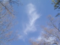 |
High clouds (cirrus, cirrocumulus, cirrostratus) observed over the middle latitudes typically reside at altitudes near and above 20,000 feet. At such rarefied altitudes, high clouds are composed of ice crystals. |
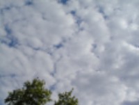 |
Middle clouds (altostratus, altocumulus) reside at an average altitude of ~10,000 feet. Keep in mind that middle clouds can form a couple of thousand feet above or below the 10,000- foot marker. Middle clouds are composed of water droplets and/or ice crystals. |
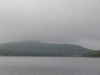 |
Low clouds (stratus, stratocumulus, nimbostratus) can form anywhere from the ground to an altitude of approximately 6,000 feet. Fog is simply a low cloud in contact with the earth's surface. |
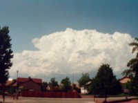 |
Clouds of vertical development (fair-weather cumulus, cumulus-congestus, cumulonimbus) cannot be classified as high, middle or low because they typically occupy more than one of the above three altitude markers. For example, the base of a tall cumulonimbus cloud often forms below 6,000 feet and then builds upward to an altitude far above 20,000 feet. |
Just by knowing the three basic cloud types (cirrus, stratus, cumulus) and the four classifications (high, middle, low, and clouds of vertical development), along with their corresponding prefixes and suffixes, we can name lots of different types of clouds.
- High clouds can either be "plain" cirrus, or we can add the prefix "cirro" to a suffix that describes their appearance (cirrostratus for high-altitude, layered clouds; cirrocumulus for high-altitude, "heap" clouds).
- Middle clouds carry the prefix "alto" and also a suffix that describes their appearance (altostratus for mid-level, layered clouds; altocumulus for mid-level, "heap" clouds).
- Clouds of vertical development always include the word "cumulus" or the prefix "cumulo," but can have various suffixes or other descriptive modifiers (like "fair-weather cumulus").
- The names of low clouds have more variation. Low clouds can be referred to as plain "stratus" (if they're smooth and layered) or "stratocumulus" if they have both layered and heap-like characteristics, for example. If low, layered clouds are precipitating, they're called nimbostratus. The prefix "nimbo" comes from "nimbus," which means that this low cloud produces precipitation (note that nimbus can also be used as a suffix, as in cumulonimbus when a cumulus cloud is producing precipitation).
To get a better feel for these various cloud types, I highly recommend checking out this interactive cloud atlas. Move your cursor over each red pin to see an example photo and description of that particular cloud type. Exploring this tool should give you a better feel for the various cloud types.
Learning to identify and describe the major cloud types can help you "read the sky," and as we learn more about the processes that make clouds throughout the course, you may be able to make your own simple weather forecasts just based on the types of clouds you see in the sky! However, now that you've looked at clouds from the bottom side, you're ready to look at clouds from the top side and tackle the principles of interpreting clouds on satellite imagery.