Prioritize...
When you've finished this page, you should be able to distinguish between in-situ and remote sensing measurements, and be able to give examples of each. You should also be able to determine whether a remote sensing instrument is active or passive.
Read...
There's no doubt that we've talked a lot about weather observations in this course (that's because they're really important to meteorologists). As I mentioned previously, many of the observations we've covered so far are taken by instruments that are in direct contact with the medium that they're "sensing." Formally, any observation taken by an instrument in direct contact with the medium it "senses" is called an in-situ observation.
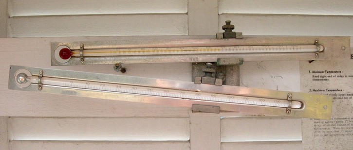
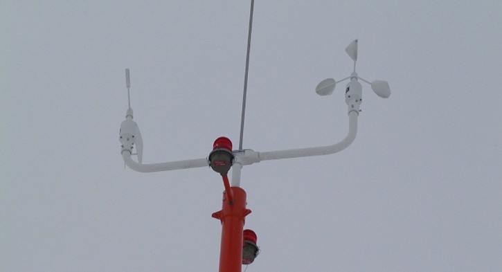
What are some common in-situ observations? Temperatures measured by standard thermometers, wind speeds and directions measured by a cup anemometer and wind vane, and precipitation measured by a rain gauge are all very common in-situ weather observations. You may have even taken your own "homemade" in-situ weather observations before. Picking up blades of grass and tossing them in the air to get a sense for the wind direction, for example, would be an example of an in-situ observation.
In-situ observations are extremely helpful to meteorologists, but they don't exist everywhere. Huge gaps exist between weather stations where temperature, dew point, winds, and precipitation are measured. That's where remote sensing comes in. By definition, a remote sensing instrument is not in direct contact with the medium that it "senses." Conventional radar and satellite images that you've probably seen online or on TV are products of remote sensing, but other types of remote sensing equipment exist even outside the world of meteorology. A medical X-ray machine, for instance, is another example of a remote sensing instrument.
Ultimately, many types of remote sensors exist, and we can further break down remote sensors into two basic types -- active and passive remote sensors. To really understand the capabilities of remote sensing instruments, it's important that you understand the difference between the two:
- Active remote sensors emit electromagnetic waves that scatter back to the sensor when they strike "targets."
- Passive remote sensors detect natural electromagnetic waves emitted or scattered by objects.
The difference between active and passive remote sensors is easy to remember if you remember that active remote sensors are "doers" (they emit radiation, which is scattered back to the sensor). One example of an active remote sensor would be an X-ray machine. These machines emit low doses of X-ray radiation into the body, which pass through and strikes a special plate, causing a chemical reaction that produces an image. Conventional weather radar is another example of an active remote sensor (as we'll cover later, the radar emits radiation which strikes targets in the atmosphere, and scatters back to the radar unit).
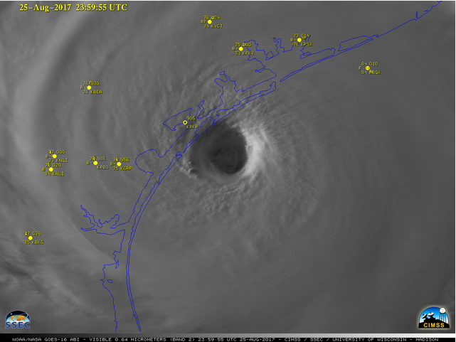
On the other hand, passive remote sensors just wait around and detect the radiation that comes to them naturally from other objects. Human eyes are a good example of passive remote sensors because they collect visible light scattered and emitted by objects. Satellite imagery, such as the image above, showing Hurricane Harvey just before landfall in southeast Texas on August 25, 2017, is also a product of passive remote sensing.
This particular satellite image was created from reflected visible light that was "seen" by a weather satellite orbiting high above the earth. Data from these satellites is transmitted back to Earth, where computers process the data and covert it into cloud pictures and other products. Also of note, the yellow dots and associated text superimposed on the satellite image above show in-situ weather observations around southeast Texas and just offshore. Obviously, there's lots of real estate not being measured by those in-situ observations! The remotely sensed satellite image, on the other hand, was able to show meteorologists the position and structure of Hurricane Harvey.
Ultimately, meteorologists get a lot of data from weather satellites, and not all satellites are created equal. Up next, we'll devote some attention to learning the differences between "geostationary satellites" and "polar-orbiting satellites." As it turns out, they each have different views of Earth because their orbits are very different. Read on!