Most remote sensing instruments measure the same thing: electromagnetic radiation. Electromagnetic radiation is a form of energy emitted by all matter above absolute zero temperature (0 Kelvin or -273° Celsius). X-rays, ultraviolet rays, visible light, infrared light, heat, microwaves, and radio and television waves are all examples of electromagnetic energy.
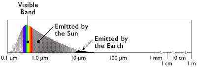
The graph above shows the relative amounts of electromagnetic energy emitted by the Sun and the Earth across the range of wavelengths called the electromagnetic spectrum. Values along the horizontal axis of the graph range from very short wavelengths (ten-millionths of a meter) to long wavelengths (meters). Note that the horizontal axis is logarithmically scaled so that each increment represents a ten-fold increase in wavelength. The axis has been interrupted three times at the long wave end of the scale to make the diagram compact enough to fit on your screen. The vertical axis of the graph represents the magnitude of radiation emitted at each wavelength.
Hotter objects radiate more electromagnetic energy than cooler objects. Hotter objects also radiate energy at shorter wavelengths than cooler objects. Thus, as the graph shows, the Sun emits more energy than the Earth, and the Sun's radiation peaks at shorter wavelengths. The portion of the electromagnetic spectrum at the peak of the Sun's radiation is called the visible band because the human visual perception system is sensitive to those wavelengths. Human vision is a powerful means of sensing electromagnetic energy within the visual band. Remote sensing technologies extend our ability to sense electromagnetic energy beyond the visible band, allowing us to see the Earth's surface in new ways, which, in turn, reveals patterns that are normally invisible.
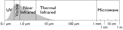
The graph above names several regions of the electromagnetic spectrum. Remote sensing systems have been developed to measure reflected or emitted energy at various wavelengths for different purposes. This chapter highlights systems designed to record radiation in the bands commonly used for land use and land cover mapping: the visible, infrared, and microwave bands.
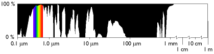
At certain wavelengths, the atmosphere poses an obstacle to satellite remote sensing by absorbing electromagnetic energy. Sensing systems are therefore designed to measure wavelengths within the windows where the transmissivity of the atmosphere is greatest.