One example of active remote sensing that everyone has heard of is radar, which stands for RAdio Detection And Ranging. Radar was developed as an air defense system during World War II and is now the primary remote sensing system air traffic controllers use to track the 40,000 daily aircraft takeoffs and landings in the U.S. Radar antennas alternately transmit and receive pulses of microwave energy. Since both the magnitude of energy transmitted and its velocity (the speed of light) are known, radar systems are able to record either the intensity or the round-trip distance traveled of pulses reflected back to the sensor. Chapter 7 mentioned the Shuttle Radar Topography Mission (SRTM) in the context of global elevation data. SRTM and other satellite altimeters measure the distance traveled by microwave pulses transmitted from the space shuttle Endeavor. Imaging radars, in contrast, measure pulse intensity.
In addition to its indispensable role in navigation, radar is also an important source of raster image data about the Earth's surface. Radar images look the way they do because of the different ways that objects reflect microwave energy. In general, rough-textured objects reflect more energy back to the sensor than smooth objects. Smooth objects, such as water bodies, are highly reflective, but unless they are perpendicular to the direction of the incoming pulse, the reflected energy all bounces off at an angle and never returns to the sensor. Rough surfaces, such as vegetated agricultural fields, tend to scatter the pulse in many directions, increasing the chance that some back scatter will return to the sensor.
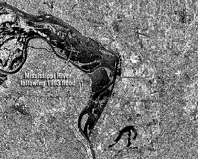
The imaging radar aboard the European Resource Satellite (ERS-1) produced the data used to create the historical image shown above. The smooth surface of the flooded Mississippi River deflected the radio signal away from the sensor, while the surrounding rougher-textured land cover reflected larger portions of the radar pulse. The lighter an object appears in the image, the more energy it reflected. Imaging radar can be used to monitor flood extents day or night, regardless of weather conditions. Passive instruments that are sensitive only to visible and near-infrared wavelengths are useless as long as cloud-covered skies prevail.