Lidar (LIght Detection And Ranging) also came up in Chapter 7, in the context of elevation data. But lidar is about much more than elevation. Along with GPS, it is one of the technologies that has truly revolutionized mapping.
So important has lidar become that Penn State has developed an entire course on it—Geography 481: Topographic Mapping with Lidar. The course is part of our Open Educational Resources Initiative, so you're free to browse its in-depth treatments of lidar system characteristics, data collection and processing techniques, and applications in topographic mapping, forestry, corridor mapping, and 3-D building modeling.
In this text, we'll emphasize just a few key points.
First, lidar is an active remote sensing technology. Like radar, lidar emits pulses of electromagnetic energy and measures the time and intensity of "returns" reflected from Earth's surface and objects on and above it. Unlike radar, lidar uses laser light. The wavelength chosen for most airborne topographic mapping lasers is 1064 nanometers, in the near-infrared band of the spectrum.
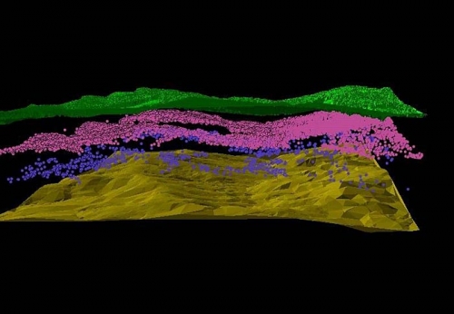
The product of a lidar scan is a 3-D cloud of mass point data. The density of points on the ground varies according to the mapping mission and platform from one to a few to hundreds of points per square meter, with corresponding accuracies of 10-15 cm to 1 cm or better. Crucial to data quality is the integration of GPS with inertial navigation systems—together called "direct georeferencing"—which enables precise positioning of mass points.
Processing lidar data involves systematically classifying points according to the various surfaces they represent—the ground surface, or above-ground surfaces like tree canopy and structures. The ability to view and interact with pseudo-stereopair images created from lidar time and intensity data make it possible to apply traditional photogrammetric techniques like break line delineation in a process called "lidargrammetry." One of the most exciting potentials of lidar data is the object-based image analysis and feature extraction its fusion with multispectral data makes possible.