The Earth's land surface reflects about three percent of all incoming solar radiation back to space. The rest is either reflected by the atmosphere or absorbed and re-radiated as infrared energy. The various objects that make up the surface absorb and reflect different amounts of energy at different wavelengths. The magnitude of energy that an object reflects or emits across a range of wavelengths is called its spectral response pattern.
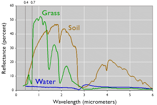
The graph below illustrates the spectral response patterns of water, brownish gray soil, and grass between about 0.3 and 6.0 micrometers. The graph shows that grass, for instance, reflects relatively little energy in the visible band (although the spike in the middle of the visible band explains why grass looks green). Like most vegetation, the chlorophyll in grass absorbs visible energy (particularly in the blue and red wavelengths) for use during photosynthesis. About half of the incoming near-infrared radiation is reflected, however, which is characteristic of healthy, hydrated vegetation. Brownish gray soil reflects more energy at longer wavelengths than grass. Water absorbs most incoming radiation across the entire range of wavelengths. Knowing their typical spectral response characteristics, it is possible to identify forests, crops, soils, and geological formations in remotely sensed imagery, and to evaluate their condition.
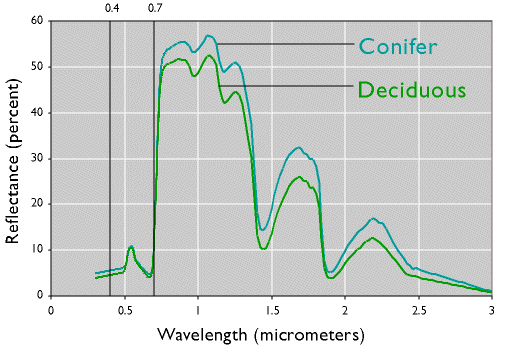
The next graph demonstrates one of the advantages of being able to see beyond the visible spectrum. The two lines represent the spectral response patterns of conifer and deciduous trees. Notice that the reflectances within the visual band are nearly identical. At longer, near- and mid-infrared wavelengths, however, the two types are much easier to differentiate. Land use and land cover mapping were previously accomplished by visual inspection of photographic imagery. Multispectral data and digital image processing make it possible to partially automate land cover mapping, which, in turn, makes it cost effective to identify some land use and land cover categories automatically, all of which makes it possible to map larger land areas more frequently.
Spectral response patterns are sometimes called spectral signatures. This term is misleading, however, because the reflectance of an entity varies with its condition, the time of year, and even the time of day. Instead of thin lines, the spectral responses of water, soil, grass, and trees might better be depicted as wide swaths to account for these variations.