The remote sensing systems you've studied so far are sensitive to the visible, near-infrared, and thermal infrared bands of the electromagnetic spectrum, wavelengths at which the magnitude of solar radiation is greatest. Quickbird, WorldView, Landsat and MODIS are all passive sensors that measure only radiation emitted by the Sun and reflected or emitted by the Earth.
Although we used the common desktop document scanner as an analogy for remote sensing instruments throughout this chapter, the analogy is actually more apt for active sensors. That's because desktop scanners must actively illuminate the object to be scanned. Similarly, active airborne and satellite-based sensors beam particular wavelengths of electromagnetic energy toward Earth's surface, and then measure the time and intensity of the pulses' returns. Over the next couple of pages, we'll consider two kinds of active sensors: imaging radar and lidar.
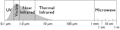
There are two main shortcomings to passive sensing of the visible and infrared bands. First, reflected visible and near-infrared radiation can only be measured during daylight hours. Second, clouds interfere with both incoming and outgoing radiation at these wavelengths. Though Lidar can be flown at night, it can't penetrate cloud cover.
Longwave radiation, or microwaves, are made up of wavelengths between about one millimeter and one meter. Microwaves can penetrate clouds, but the Sun and Earth emit so little longwave radiation that it can't be measured easily at altitude. Active imaging radar systems solve this problem. Active sensors like those aboard the European Space Agency's ERS and Envisat, India's RISAT, and Canada's Radarsat, among others, transmit pulses of longwave radiation, then measure the intensity and travel time of those pulses after they are reflected back to space from the Earth's surface. Microwave sensing is unaffected by cloud cover, and can operate day or night. Both image data and elevation data can be produced by microwave sensing, as you'll see in the following page.