Environmental scientists rely on global vegetation and land cover data to monitor drought conditions that may lead to famine and to calibrate global- and regional-scale climate models, among other uses. Land cover studies around the world vary greatly both temporally and spatially. The most detailed contemporary global land datasets we're aware of is GlobeLand30, which depicts ten land cover types at 30-meter resolution for Earth's entire land surface, for both 2000 and 2010. China's National Geomatics Center produced the datasets from over 20,000 Landsat and Chinese HJ-1 scenes and donated them to the United Nations in September 2014. Other global datasets include GlobCover, a 22-class, 300-meter resolution dataset created by the European Space Agency. They created GlobCover from imagery produced by the Envisat Medium Resolution Imaging Spectrometer (MERIS) from 2004-06, then again in 2009. The Global Land Cover Facility at the University of Maryland offers more recent if lower resolution MODIS land cover and vegetation annual mosaics for 2001-2017. Meanwhile, beginning in 2014, Esri collaborated with USGS to create a Global Ecological Land Units map that characterizes each 250-meter resolution "facet" of Earth's surface as a function of four input layers that drive ecological processes: bioclimate, landform, lithology, and land cover.
The following case study describes the production of one of the earliest global composite vegetation maps. While it is a historical example, it is an exceptionally well-documented one that illuminates an image processing workflow that remains relevant today.
The Advanced Very High-Resolution Radiometer (AVHRR) sensors aboard NOAA satellites scan the entire Earth daily at visible red, near-infrared, and thermal infrared wavelengths. In the late 1980s and early 1990s, several international agencies identified the need to compile a baseline, cloud-free, global NDVI data set in support of efforts to monitor global vegetation cover. For example, the United Nations mandated its Food and Agriculture Organization to perform a global forest inventory as part of its Forest Resources Assessment Project. Scientists participating in NASA's Earth Observing System program also needed a global AVHRR data set of uniform quality to calibrate computer models intended to monitor and predict global environmental change. In 1992, under contract with the USGS, and in cooperation with the International Geosphere Biosphere Programme, scientists at the EROS Data Center in Sioux Falls, South Dakota started work. Their goals were to create not only a single 10-day composite image, but also a 30-month time series of composites that would help Earth system scientists to understand seasonal changes in vegetation cover at a global scale.
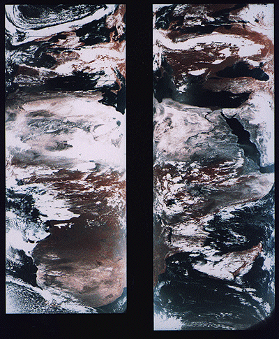
From 1992 through 1996, a network of 30 ground receiving stations acquired and archived tens of thousands of scenes from an AVHRR sensor aboard one of NOAA's polar orbiting satellites. Individual scenes were stitched together into daily orbital passes like the ones illustrated below. Creating orbital passes allowed the project team to discard the redundant data in overlapping scenes acquired by different receiving stations.
Once the daily orbital scenes were stitched together, the project team set to work preparing cloud-free, 10-day composite data sets that included Normalized Difference Vegetation Index (NDVI) scores. The image processing steps involved included radiometric calibration, atmospheric correction, NDVI calculation, geometric correction, regional compositing, and projection of composited scenes. Each step is described briefly below.
Radiometric calibration
Radiometric calibration means defining the relationship between reflectance values recorded by a sensor from space and actual radiances measured with spectrometers on the ground. The accuracy of the AVHRR visible red and near-IR sensors degrade over time. Image analysts would not be able to produce useful time series of composite data sets unless reflectances were reliably calibrated. The project team relied on research that showed how AVHRR data acquired at different times could be normalized using a correction factor derived by analyzing reflectance values associated with homogeneous desert areas.
Atmospheric correction
Several atmospheric phenomena, including Rayleigh scatter, ozone, water vapor, and aerosols were known to affect reflectances measured by sensors like AVHRR. Research yielded corrections to compensate for some of these.
One proven correction was for Rayleigh scatter. Named for an English physicist who worked in the early 20th century, Rayleigh scatter is the phenomenon that accounts for the fact that the sky appears blue. Short wavelengths of incoming solar radiation tend to be diffused by tiny particles in the atmosphere. Since blue wavelengths are the shortest in the visible band, they tend to be scattered more than green, red, and other colors of light. Rayleigh scatter is also the primary cause of atmospheric haze.
Because the AVHRR sensor scans such a wide swath, image analysts couldn't be satisfied with applying a constant haze compensation factor throughout entire scenes. To scan its 2400-km wide swath, the AVHRR sensor sweeps a scan head through an arc of 110°. Consequently, the viewing angle between the scan head and the Earth's surface varies from 0° in the middle of the swath to about 55° at the edges. Obviously, the lengths of the paths traveled by reflected radiation toward the sensor vary considerably depending on the viewing angle. Project scientists had to take this into account when compensating for atmospheric haze. The further a pixel was located from the center of a swath, the greater its path length, and the more haze needed to be compensated for. While they were at it, image analysts also factored in terrain elevation, since that, too, affects path length. ETOPO5, the most detailed global digital elevation model available at the time, was used to calculate path lengths adjusted for elevation. (You learned about the more detailed ETOPO1 in Chapter 7.)
NDVI calculation
The Normalized Difference Vegetation Index (NDVI) is the difference of near-IR and visible red reflectance values normalized over the sum of the two values. The result, calculated for every pixel in every daily orbital pass, is a value between -1.0 and 1.0, where 1.0 represents maximum photosynthetic activity, and thus maximum density and vigor of green vegetation.
Geometric correction and projection
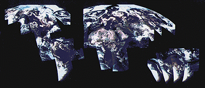
As you can see in the stitched orbital passes illustrated above, the wide range of view angles produced by the AVHRR sensor results in a great deal of geometric distortion. Relief displacement makes matters worse, distorting images even more towards the edges of each swath. The project team performed both orthorectification and rubber sheeting to rectify the data. The ETOPO5 global digital elevation model was again used to calculate corrections for scale distortions caused by relief displacement. To correct for distortions caused by the wide range of sensor view angles, analysts identified well-defined features like coastlines, lakeshores, and rivers in the imagery that could be matched to known locations on the ground. They derived coordinate transformation equations by analyzing differences between positions of control points in the imagery and known locations on the ground. The accuracy of control locations in the rectified imagery was shown to be no worse than 1,000 meters from actual locations. Equally important, the georegistration error between rectified daily orbital passes was shown to be less than one pixel.
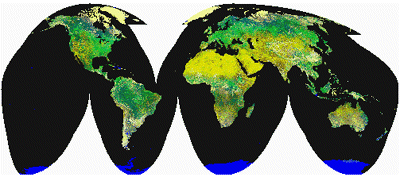
After the daily orbital passes were rectified, they were transformed into a map projection called Goode's Homolosine. This is an equal-area projection that minimizes shape distortion of land masses by interrupting the graticule over the oceans. The project team selected Goode's projection in part because they knew that equivalence of area would be a useful quality for spatial analysis. More importantly, the interrupted projection allowed the team to process the data set as twelve separate regions that could be spliced back together later. Figure 8.17.2 shows the orbital passes for June 24, 1992, projected together in a single global image based on Goode's projection.
Compositing
Once the daily orbital passes for a ten-day period were rectified, every one-kilometer square pixel could be associated with corresponding pixels at the same location in other orbital passes. At this stage, with the orbital passes assembled into twelve regions derived from the interrupted Goode's projection, image analysts identified the highest NDVI value for each pixel in a given ten-day period. They then produced ten-day composite regions by combining all the maximum-value pixels into a single regional data set. This procedure minimized the chances that cloud-contaminated pixels would be included in the final composite data set. Finally, the composite regions were assembled into a single data set, illustrated below. This same procedure has been repeated to create 93 ten-day composites from April 1-10, 1992 to May 21-30, 1996.