Teleconnections: Looking for Seasonal Signals
The Climate Prediction Center (CPC) is the climate-forecasting cousin of the National Weather Service. Around the middle of each month, CPC forecasters issue outlooks for temperature and precipitation for the next calendar month and for all three-month periods during the coming year. The outlooks are simple, categorical, probability forecasts. The categories are "above average," "near average," and "below average."
As an example, let's say forecasters are preparing an outlook for temperature for the upcoming three months. They begin by assuming that each of the three categories is equally likely; in other words, that each of the three categories (warmer-than-average, near-average, and colder-than-average) has a 33 1/3 percent probability of occurring. Not surprisingly, this forecast essentially boils down to "climatology." Forecasters then adjust the percentages up or down for each region of the country to reflect their degree of confidence in one of the three categories. Usually, the adjustments aren't very large; only occasionally would any of the probabilities be increased to more than 50 percent. In some areas, no adjustments are made because forecasters really can't do much better than climatology (equal chances of all three categories). The end product is a map that shows regions of the country where forecasters increased the "warmer-than-average" probability above 33 1/3 percent or the "colder-than-average" probability above 33 1/3 percent, with the rest of the country essentially equal chances of all three categories (climatology).
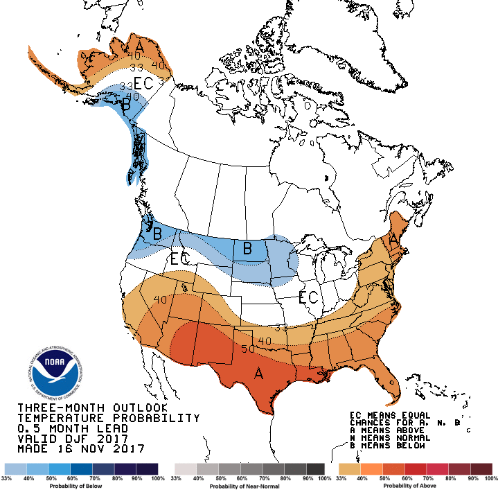
The long-range forecast shown above is the temperature outlook issued by CPC in mid-November 2017 for the three-month period of December 2017 through February 2018. In the brown-shaded regions, forecasters leaned toward above-average temperatures; the darker the shading, the greater the level of confidence for above-average temperatures in these regions during the period. Forecasters placed their greatest confidence in an area from eastern Arizona to southern Louisiana where the pocket of darkest brown (marked by an "A") indicates a probability of 50 percent or slightly higher that temperatures would be above-average. Forecasters had less confidence in above-average temperatures for this period in the region extending from southern California and Nevada into the Southeast (as well as extreme northern and western Alaska), where the moderately dark brown indicates probabilities of 40 percent or slightly higher (but still more likely than climatology).
The darkest blue shading that extends from parts of Oregon and Washington into the Dakotas, and also includes southeastern Alaska, indicates a probability of 40 percent or slightly higher that temperatures would be below average for the three-month period. Here, forecasters had a relatively high confidence, but they were not quite as confident as their prediction for above-average temperatures from eastern Arizona to Louisiana. The lighter blue indicates where the probability for below-average temperatures was between 33 1/3 and 40 percent. Again, these percentages simply mean that the odds were slightly greater than climatology that temperatures would be below average from December to February. By the way, "EC" translates to "Equal Chances," meaning that all three categories (above-, below- and near-average) are equally probable - essentially, a forecast of climatology.
We cannot emphasize enough that, even in the areas of greatest confidence (dark brown and moderately dark blue on these forecast charts), you should not interpret the forecast as a sure bet, as the media sometimes implies. The bottom line here is that the brown- and blue-shaded regions represent areas where forecasters place the odds higher than climatology for above-average or below-average temperatures.
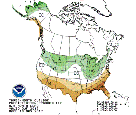
Not to be overlooked, we include the corresponding outlook for precipitation during the period December 2017 to February 2018 (above). You should invest some time and interpret the long-range outlook for yourself.
So how do forecasters make adjustments to climatology? Tracking the current high- and low-pressure systems has no value in monthly and seasonal forecasting; these transient weather systems will be long gone a month or two in the future. Instead, forecasters focus on determining the large-scale pattern of the jet stream. Specifically, they are interested in the position of the long-wave troughs and ridges. If forecasters can ascertain the average positions of the long waves with any degree of accuracy, then they have a scientific basis for adjusting the overall temperature and precipitation patterns.
Long-range forecasters sometimes look to the past to predict the future. Yes, you read that correctly. To do this, forecasters rely on a technique called analog forecasting. Analog comes from the word "analogy," which means "likeness" or "similarity." Here's how it works. Meteorologists first determine the average positions of the long-wave troughs and ridges in the jet stream during the weeks and months leading up to the present. Then they look for previous years during which a similar pattern occurred during the same season. Stated simply, they look for "analogs." Forecasters then follow the evolution of the upper-air flow during those analog years, note the evolution of the general temperature and precipitation patterns, and then incorporate these patterns into their seasonal outlooks.
Analog forecasting has been around for decades, but it's utility for monthly and seasonal forecasting has increased in recent years. That's almost entirely a result of our evolving understanding of teleconnections. El Niño and La Niña are two of the "biggie" teleconnections that have proven useful for forecasting on times scales of months and seasons.
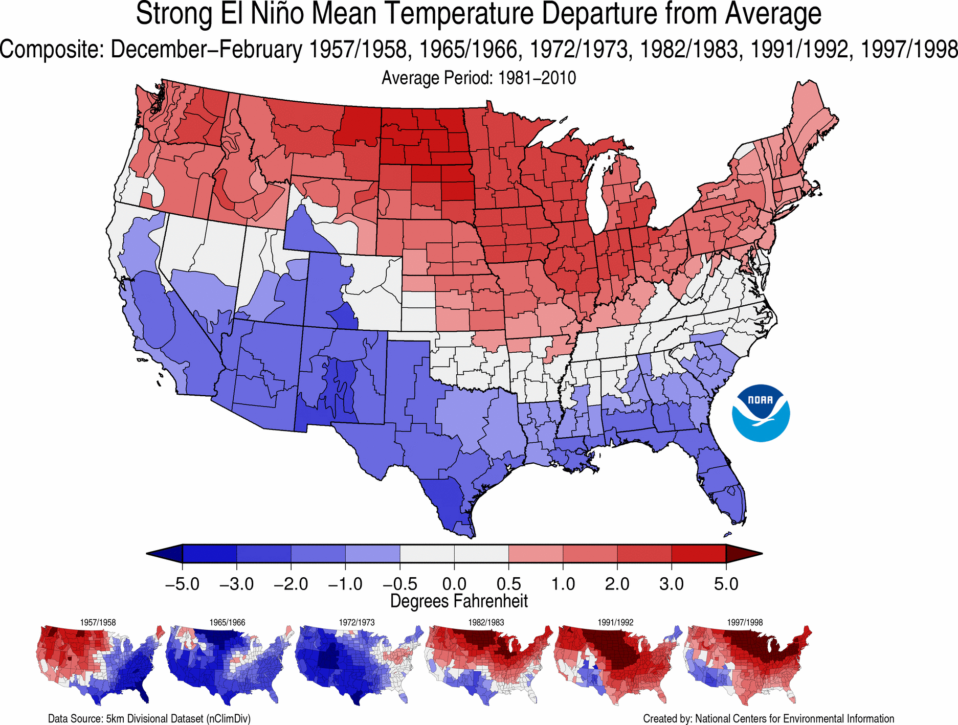
Strong El Niño episodes can have the most dramatic impacts on global weather patterns. For the record, sea-surface temperatures between the International Date Line and the west coast of South America during a strong El Niño can be 2.0-3.5°C (4 - 6°F) above average. With an El Niño looming in the equatorial Pacific Ocean, seasonal forecasters can prepare their winter forecasts based on how weather patterns evolved during other strong El Niño episodes in the past. The image above shows how winter (December to February) temperatures ranked among the climate division records dating back to 1895, during winters when a strong El Niño was in progress (the years of the strong El Niño episodes used in the analysis are listed across the top of the image). Clearly, with a strong El Niño in progress, a seasonal forecaster worth his or her salt would likely not predict colder-than-average conditions across the northern tier of the country. Indeed, winters when a strong El Niño was in progress were some of the warmest on record in northern Montana and northern North Dakota (darkest red). In fact, this diagram suggests that much of the northern tier of the United States, from Washington and Oregon to Upstate New York and parts of New England, tends to have a warmer-than-average winter when a strong El Niño is underway. Here's the twin image of winter precipitation for strong El Niño episodes. You should study it and decide how you would introduce this teleconnection into your own seasonal forecast the next time a strong El Niño develops. In case you' interested, here's the most recent loop of sea-surface temperatures and anomalies over the equatorial Pacific Ocean.
Admittedly, because strong El Niños don't happen that often, being able to use the teleconnection to strong El Niños seasonal forecasts doesn't happen very often. But there are teleconnections from weaker El Niños (and La Niñas) that long-range forecasters more frequently incorporate into their seasonal outlooks (read more).
We end this chapter by expanding our focus on teleconnections.