
Surface Ocean Circulation
The circulation of the surface ocean is driven primarily by surface winds. As we have seen, winds blow from areas of high atmospheric pressure to regions of low atmospheric pressure. These winds are generally transferring heat from areas where there is excess incoming radiation (the tropics and subtropics) to temperate and higher latitude regions, where there is a net loss of heat. Typically speaking, the distribution of pressure on the Earth’s surface is zonal or meridional, with high-pressure bands covering the subtropics and polar regions and low-pressure bands, the equatorial regions, and subpolar regions.
Where winds and surface currents are moving along a coastline, they draw the surface water away from the coast. The surface waters are replaced by waters from below by the upwelling described earlier. This is shown in the figure below.
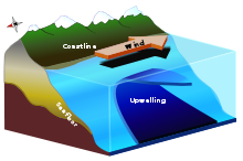
The image is a diagram illustrating the process of upwelling along a coastline. It features a cross-sectional view of a coastal area with mountains on the left, transitioning into a body of water on the right. A wind arrow points parallel to the coast, driving surface water movement. The diagram highlights the upwelling process, where deeper, nutrient-rich water rises to the surface, depicted with labeled sections for the coast, wind, upwelling, and seafloor.
- Left Section
- Feature: Mountains
- Color: Green with white peaks
- Position: Left side of the diagram
- Coastal Area
- Label: Coast
- Position: Adjacent to mountains, transitioning into water
- Color: Yellowish-brown
- Water Body
- Color: Blue, with darker blue indicating deeper water
- Sections:
- Surface water: Moved by wind
- Deeper water: Source of upwelling
- Wind Indicator
- Label: Wind
- Representation: Arrow pointing parallel to the coast
- Color: Black
- Position: Above the coastal water surface
- Upwelling Process
- Label: Upwelling
- Description: Rising of deeper water to the surface
- Position: Central water area, shown as an upward flow
- Color: Dark blue transitioning to lighter blue
- Seafloor
- Label: Seafloor
- Position: Bottom of the water body
- Color: Dark brown
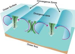
The image is a diagram illustrating ocean water movement, highlighting convergence zones, divergence zones, upwelling, and downwelling processes. It features a cross-sectional view of the ocean, with the ocean surface at the top and the ocean floor at the bottom. The diagram shows water circulation patterns with arrows indicating movement: green arrows represent upwelling (water rising from the ocean floor) and downwelling (water sinking from the surface), while blue arrows indicate broader circulation. The convergence zones are marked where water flows meet and sink, and the divergence zone is where water spreads apart and rises.
- Top Section
- Feature: Ocean Surface
- Color: Light blue
- Position: Top of the diagram
- Bottom Section
- Feature: Ocean Floor
- Color: Light brown
- Position: Bottom of the diagram
- Water Circulation Patterns
- Color: Blue arrows for general flow
- Green arrows for specific movements:
- Upwelling: Water rising from the ocean floor
- Downwelling: Water sinking from the ocean surface
- Convergence Zones
- Label: Convergence Zones
- Description: Areas where water flows meet and sink
- Position: Top center, marked with black arrows pointing inward
- Color: Indicated by overlapping blue flow lines
- Divergence Zone
- Label: Divergence Zone
- Description: Area where water spreads apart and rises
- Position: Central area, marked with green upwelling arrows
- Color: Indicated by spreading blue flow lines
Upwelling also happens in parts of the ocean where winds cause surface currents to diverge or move away from one another. Downwelling is the opposite process to upwelling, where surface waters flow downwards and replace deep waters. This occurs in parts of the ocean where surface winds are converging. One place this happens is in the centers of gyres.