
Behavior of Water
Because of the significance of this groundwater for human use, we consider the behavior of water underground in some detail here. It might seem complex at first, but water flow follows very simple laws of physics.
Water Tables and Aquifers
Water at the surface of the Earth seeps slowly into the soil, a process known as percolation. Water will percolate through the uppermost layer of soil and loose material that contains air, the aerated zone, down to a level called the water table. The water table is at the top of the permanently waterlogged or saturated level.
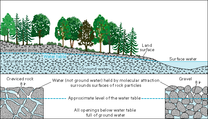
A cross-sectional diagram illustrating the distribution of groundwater and related zones beneath the Earth's surface. It shows a forested landscape with trees on the left, transitioning to a body of surface water on the right. The diagram is divided into layers: the unsaturated zone above the water table, where air and water coexist in the soil, and the saturated zone below, where all pore spaces are filled with groundwater. The water table marks the boundary between these zones. Below the saturated zone, there is a layer of creviced rock on the left, containing water (not groundwater) held by molecular attraction in rock crevices, with all openings below the water table filled with groundwater. On the right, a gravel layer is shown, also saturated with groundwater. Labels indicate the land surface, surface water, and the approximate level of the water table.
- Surface Features
- Land Surface
- Position: Left side
- Visual: Forested area with trees
- Color: Green with brown soil
- Surface Water
- Position: Right side
- Visual: Body of water
- Color: Blue
- Land Surface
- Subsurface Zones
- Unsaturated Zone
- Position: Above the water table
- Description: Soil with air and water in pore spaces
- Color: Light brown with white patches
- Water Table
- Position: Boundary between unsaturated and saturated zones
- Visual: Dashed blue line
- Saturated Zone
- Position: Below the water table
- Description: All pore spaces filled with groundwater
- Color: Blue with white speckles
- Ground Water
- Position: Within the saturated zone
- Description: Water filling all pore spaces
- Unsaturated Zone
- Rock and Gravel Layers
- Creviced Rock
- Position: Bottom left
- Description: Water (not groundwater) held by molecular attraction in rock crevices
- Visual: Gray rock with blue water in crevices
- Note: All openings below water table full of groundwater
- Gravel
- Position: Bottom right
- Description: Saturated with groundwater
- Visual: Rounded pebbles with blue water filling spaces
- Creviced Rock
- Labels and Annotations
- Approximate Level of the Water Table
- Visual: Dashed blue line across the diagram
- Water (not ground water) Held by Molecular Attraction
- Position: Near the creviced rock section
- All Openings Below Water Table Full of Ground Water
- Position: Below the creviced rock section
- Approximate Level of the Water Table
The water table is a critical level because it determines the level of groundwater available for drinking and irrigation. The flow of water underground is controlled by a number of factors, including the permeability of the aquifer and the hydraulic gradient. Explained simply, the hydraulic gradient between two wells is the difference in hydraulic pressure (known as hydraulic head) divided by the distance between them. If the difference in hydraulic head is high, water will flow readily; if the difference is nil, then water will only flow if pumped. The hydraulic gradient at points at the top of the water table is generally level.
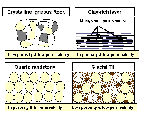
Relationship between porosity and permeability
- Crystalline Igneous Rock - low porosity and low permeability
- Clay-rich layer (many small pore spaces) - high porosity and low permeability
- Quartz Sandstone - high porosity and high permeability
- Glacial Till - low porosity and low permeability
The permeability of a rock is a function of a number of factors that include the amount of pore space, the arrangement of pores, and the amount of surface tension from grains, especially tiny (micron-sized) clay minerals that have very high surface area. The larger the pore space, the more connected the grains and the less clay, the higher the permeability, and the more easily water flows. Conversely, where pore space is tight and poorly connected, and there is a lot of clay, permeability is low and water cannot flow readily.
The best aquifers are often made of rocks with both high porosity and high permeability, such as sandstone, but rocks with generally lower porosity can also be highly permeable. For example, limestone is often jointed and is readily dissolved by groundwater, leaving the rock highly permeable; rocks such as granite and basalt are often heavily fractured allowing water to flow readily. Some of the most productive aquifers are called “contained” or “confined,” and are sandwiched between low-permeability layers called “aquicludes.” Common aquicludes are shale and mudstone layers. Such contained aquifers can have a high hydraulic gradient because the aquicludes hold a significant hydraulic head; confined aquifers often produce wells called artesian wells that, owing to substantial confining pressure, produce water without pumping.
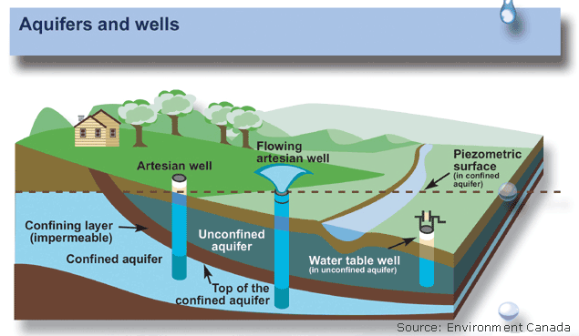
A diagram titled "Aquifers and wells," sourced from Environment Canada, illustrating the structure and function of different types of aquifers and wells. It features a cross-sectional view of a landscape with a house, trees, and a river, showing subsurface layers. The diagram includes an unconfined aquifer near the surface with a water table, accessible by an artesian well and a flowing artesian well where water rises naturally above the surface. Below this, a confined aquifer is separated by a confining (impermeable) layer, accessed by another artesian well. A piezometric surface is shown above the confined aquifer, indicating the potential water level in a well. Labels highlight the top of the confined aquifer, water in the unconfined aquifer, and a well in the confined aquifer.
- Diagram Overview
- Title: Aquifers and wells
- Source: Environment Canada
- Type: Cross-sectional view of subsurface water systems
- Surface Features
- Landscape: House, trees, and a river
- Color: Green land, blue water
- Subsurface Layers
- Unconfined Aquifer
- Position: Near the surface, above the confined aquifer
- Description: Contains water table, accessible by wells
- Color: Light blue
- Confining Layer (Impermeable)
- Position: Between unconfined and confined aquifers
- Description: Prevents water movement
- Color: Brown
- Confined Aquifer
- Position: Below the confining layer
- Description: Contains pressurized water
- Color: Blue
- Unconfined Aquifer
- Wells
- Artesian Well
- Position: Left side, in unconfined aquifer
- Description: Well with water level at or below the surface
- Flowing Artesian Well
- Position: Center, in unconfined aquifer
- Description: Water rises naturally above the surface
- Well in Confined Aquifer
- Position: Right side
- Description: Accesses confined aquifer water
- Artesian Well
- Piezometric Surface
- Position: Above the confined aquifer
- Description: Indicates potential water level in a well
- Visual: Dashed line with a bubble
- Position: Above the confined aquifer
- Labels and Annotations
- Top of the Confined Aquifer
- Position: Within the confined aquifer
- Water in Unconfined Aquifer (in water table well)
- Position: Within the unconfined aquifer
- Approximate Level of the Water Table
- Visual: Dashed line across the diagram
- Top of the Confined Aquifer
In other cases, the tops of aquifers are not confined by an impermeable layer. Such aquifers are called unconfined and will, all other things being equal, be characterized by less confining pressure. Groundwater is continuously exchanging with other reservoirs in the hydrological cycle. Aquifers are recharged with water from rain and snow percolating through the aerated zone. Conversely, groundwater flows back into rivers and lakes or into wells and springs in a process known as discharge. The time water spends underground is called the residence time, which varies from a few days to 10,000 years or more. As we will see later, the water table can move downward as a result of drought, and this is happening in arid areas today.