
Saltwater Incursion
A serious problem can result from the overuse of groundwater in coastal regions. Here, there is the potential for salt water to flood into the void where aquifers are drained excessively. This process, which is termed saltwater incursion or saltwater intrusion, happens readily because salt water has a higher density than fresh water, hence the pressure under a column of seawater is greater than the pressure under an equivalent volume of fresh water. This results in flow into freshwater aquifers near the coast. Humans and other mammals cannot process large amounts of sodium in water. Ultimately, it leads to renal (kidney) failure. This is why early explorers who became lost at sea were told not to drink seawater. Likewise, salt water kills crops.
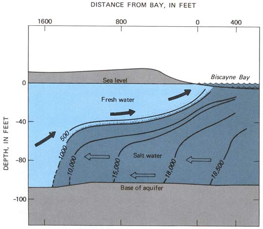
A cross-sectional diagram illustrating the interaction between fresh water and salt water in an aquifer near Biscayne Bay, with depth in feet on the y-axis (0 to -1600 feet) and distance from the bay in feet on the x-axis (0 to 1600 feet). It shows sea level at the top, with Biscayne Bay on the right. Fresh water flows from the left toward the bay, forming a lens above denser salt water, which extends deeper and further inland. The diagram includes contour lines indicating the interface between fresh water and salt water at depths of -500, -10,000, -15,000, and -18,500 feet, with arrows showing the direction of water movement. The base of the aquifer is marked at the bottom.
- Surface Features
- Sea Level
- Position: Top of the diagram
- Color: Gray
- Biscayne Bay
- Position: Right side
- Color: Blue
- Sea Level
- Water Layers
- Fresh Water
- Position: Upper layer, left to right
- Description: Flows toward the bay
- Color: Light blue
- Visual: Arrows pointing right
- Salt Water
- Position: Lower layer, extending inland
- Description: Denser, beneath fresh water
- Color: Dark blue
- Visual: Arrows pointing left
- Fresh Water
- Contour Lines (Interface)
- Depths: -500, -10,000, -15,000, -18,500 feet
- Position: Curved lines showing the fresh-salt water boundary
- Visual: Black lines with depth labels
- Depths: -500, -10,000, -15,000, -18,500 feet
- Base of Aquifer
- Position: Bottom of the diagram
- Description: Underlying layer
- Color: Gray-brown
Saltwater incursion can occur in one of three ways, all as a result of over-pumping. The first is large-scale, lateral flow into the coastal aquifer, the second is vertical upward flow, and the third is flow into the aquifer from coastal streams and canals, often forced by tidal movements.
Probably the most well-studied example of saltwater intrusion occurs in south Florida, where development combined with highly irregular precipitation patterns have stressed local aquifers. The Biscayne aquifer is the main source of drinking water in the Miami metropolitan area. The aquifer is unconfined, meaning that it is not overlain by aquitards, i.e., it lies at the surface. This renders the Biscayne sensitive to changes in rainfall, evaporation, and over-pumping. Saltwater intrusion occurs as a wedge underneath the surface with a transitional interface with the overlying Biscayne aquifer.
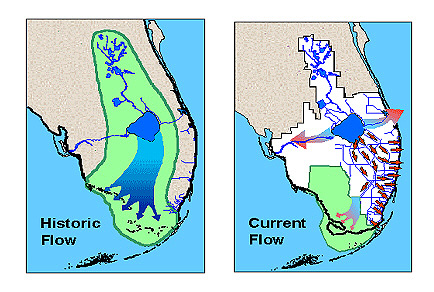
Two side-by-side maps comparing water flow patterns in a region, likely the Everglades in Florida. The left map, labeled "Historic Flow," shows a broad, continuous flow of water in blue, moving southward across a large green area, representing natural wetlands and water bodies, with minimal human interference. The right map, labeled "Current Flow," illustrates a significantly altered flow pattern, with water confined to narrow channels and canals depicted by blue lines. The green area is reduced, and there are white patches indicating urban or developed land, with red arrows showing the direction of water flow, primarily southeastward, reflecting modern water management systems.
- Left Map (Historic Flow)
- Label: Historic Flow
- Water Flow: Broad, continuous southward flow
- Color: Blue
- Position: Across a large green area
- Landscape: Predominantly green wetlands and water bodies
- Color: Green
- Human Interference: Minimal, natural flow pattern
- Right Map (Current Flow)
- Label: Current Flow
- Water Flow: Narrow channels and canals
- Color: Blue lines
- Direction: Red arrows indicating southeastward flow
- Landscape: Reduced green wetlands, white patches for urban/developed land
- Color: Green for wetlands, white for developed areas
- Human Interference: Extensive, with water management systems
- Additional Notes
- Region: Likely the Everglades in Florida
- Comparison: Highlights changes from natural to managed water flow
The history of incursion dates back to the 1900s as defined by the first measured increase in salinity (chloride levels) in the Biscayne aquifer. Construction of drainage canals began in 1909 and this resulted in the further inland intrusion of salt water. Intrusion continued unabated until 1946 when salinity-control structures were constructed to prevent inland, tidal movements of salt water. In the 1960s, a large drainage canal system was constructed as part of the massive development of south Florida.
The canals included flow-control structures to prevent excessive drainage from the canal system. However, the design of the structures led to a lowering of freshwater levels in the Biscayne aquifer, leading in turn to increased saltwater intrusion, especially during drought years. Continued movement of the saltwater lens towards the coast and inland has occurred as the new parts of the aquifer have been developed and others tapped less intensively. As in other coastal regions, saltwater intrusion is an ongoing issue that will require constant monitoring as development continues, and demand on aquifers increases. The potential of saltwater intrusion is one issue behind the development of desalinization technology in arid regions.
Sea level rise will increase salinization of coastal aquifers, especially in areas that are dry or subject to seasonal rainfall variability.