
Fire
Los Angeles Fires 2025
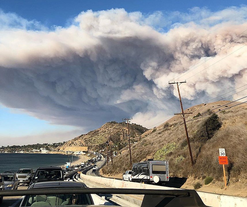
January 2025 will forever be remembered for the fires that decimated parts of Los Angeles. The fires lasted for 24 days caused a total of $250-275 billion in damage, an estimate that will likely keep rising. The fires destroyed 18,000 structures, burned 57,000 acres and caused 29 fatalities; 200,000 people were forced to evacuate. The fires started during a stretch of warm and very dry conditions, the driest 9-month period in California history with almost no rain at all, and were spread by strong Santa Ana winds which gusted up to 100 mph, producing literal firestorms that proved very difficult to contain.
It's still uncertain what triggered the fires, but it is likely sparks from electrical equipment. There were eight separate blazes, but two areas were most devastated, Pacific Palisades near the coast and Altadena more inland. The scale of the fires was unprecedented and firefighters had a hard time fighting so many fires simultaneously.
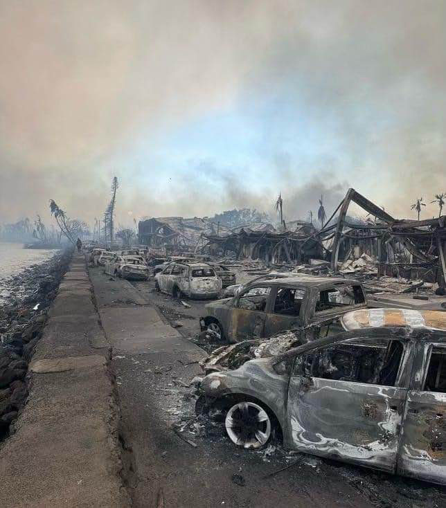
The Palisades fire in Pacific Palisades, Topanga and Malibu destroyed 6800 structures, burned 23,000 acres and killed 12 people. The fire spread extremely rapidly and covered 1200 acres in a matter of hours. Major evacuations were ordered because of the major threat and major traffic jams resulted. Residents reported leaving homes without most of their possessions and pets were also left behind. The area covered by the Palisades fire is the home of many Hollywood celebrities, so the fire got a lot of press coverage. The fire got so large so fast that hydrants ran out of water for a short period of time early in the blaze and this hindered firefighting efforts. The fire burned for 24 days till it was contained and became the third most destructive fire in California history.
The Eaton fire in Altadena destroyed 9000 structures including 4400 family homes and killed 17 people with 24 still missing. When the fire started the winds were so strong embers settled on structures a mile away and the fire spread very quickly, rapidly burning 1000 acres and growing to 2200 acres including surrounding mountainous areas. 100,000 people were placed under evacuation orders. The cause of the fire is unknown, but it was likely started by sparks from powerlines. Lawsuits have already been brought against Southern California Edison, the local power company. Like the Palisades fire, it took 24 days to extinguish the Eaton fire. By that time, it was the second most destructive fire in California history
The aftermath of the two fires included severe air pollution as the burnt structures that contained lead paint, asbestos, and vehicles, and solar powered batteries and panels, that contained various heavy metals. Wildfire smoke contains a number of pollutants including fine particulate matter (PM 2.5). These tiny particles can invade the lungs and penetrate the bloodstream causing a number of respiratory and cognitive illnesses along with cancer. Residents were told to stay inside even after the fires were extinguished. The threat continued as subsequent heavy rainfall led to mudflows laden with toxic materials.
Hawaii Fires 2023
Summer 2023 will be remembered for the truly devastating and catastrophic fires that destroyed the historic tourist city of Lahaina in Maui. As of the date of writing the fire caused 115 fatalities with 66 people still unaccounted for. More than 2200 buildings were destroyed and damage expected to exceed $6 billion. The cause of the tragedy is still under investigation, but it was likely sparked by electric utility poles downed by hurricane force winds. These same winds were responsible for the exceedingly rapid spread of the fires that made evacuation extremely difficult. The failure of warning systems to alert residents is also under investigation. Almost certainly, climate change is at least partially responsible for the fires. A lush tropical island, Maui like the rest of Hawaii, has become much drier since 1990 especially during the summer wet season. Hotter temperatures result in thinner clouds which hold less rainfall. Another critical factor is the area around Lahaina, once the site of sugar cane farms, is now covered by invasive grasses that acted like a tinderbox during the fires. Sadly the Lahaina tragedy is a sign of the future of many places around the globe.
The 2023 summer began with smoke-filled skies across the eastern US from fires raging in Canada. The quality of the air in New York City was the worst of any large city in the world. The last five years have brought devastating fires to California and other western states! Images from the news have shown San Francisco’s air full of smoke and glowing red. Every year brings new records and new tragedies. Deadly fires are not unique to California; in fact, Australia has a history of particularly devastating fires. And climate change is going to provide all of the ingredients for more fires in the future: more fuel (from extreme rainfall events), more effective natural ignition (often dry lightning) and often, sadly, arson, as well as the conditions to keep fires burning (drought and heat). The latest IPCC report issues some stern warnings about fire, predicting that the livelihood of millions of people will be impacted by wildfires in the future. The citizens of California, Australia and other parts of the world need to get used to apocalyptic fires. The last five years have been a wake up call.
The Camp Fire, November 2018
The deadly Camp fire, the most deadly and destructive fire in California history, began November 8th, 2018 from a spark from an electrical wire. By the time it was finished two weeks later, the fire had burned more than 1500,000 acres around the town of Paradise. The fire occurred late in the season and was whipped up by strong winds and abundant fuel from the previous rainy season. A virtual firestorm quickly converged on Paradise, a ridge-top town that was used to fires but had grown fast and without good evacuation planning. On November 8th, the evacuation order came too late, and many folks did not receive it because cell towers were down. Because the call was so late, evacuation could not occur in an orderly fashion, from one side of the town to the other. Hundreds of vehicles quickly jammed the three routes out of town and the fire quickly trapped many people in their cars. Folks who did not get the evacuation order were trapped in their homes. A total of 86 people in Paradise were killed and the town was almost completely burned down.
In the wake of the fire, the large utility company PG&E filed for bankruptcy to avoid major lawsuits. Turns out the company discussed turning off the power grid in the days before the fire began but decided not to. Now in the wake of the fire, companies will be much more likely to turn off the grid if there is a chance of fire and this will impact millions of customers in California.
As it turns out the Camp fire was only one of two major fires that began on November 8th. The massive Woolsey fire west of LA also began that day, burned 97,000 acres, killed three people, and forced the evacuation of 295,000 people.
The Camp and Woolsey fires are the “new normal” for California and the state must deal with difficult issues such as vegetation management, sensible development, evacuation planning, and regulation of power companies.
The record breaking 2020 fire season
2020 was a record-breaking fire year in California. More acres burned than ever before (over 4.3 million), at least in recent times, with over 9200 separate fires including the first “gigafire”, the August Complex Fire that burned more than 1 million acres (over 1500 square miles)! Total damages exceeded $2.5 billion and 32 people perished. Although arson was to blame for some of the fires, more often they were sparked by lightning that occurred in thunderstorms without rain. The largest fires in Northern California, the SZU Lightning Complex fire, the LNU Lightning Complex Fire, and the August fire were all started by lightning strikes.
Video: California wildfires evening update: September 9, 2020 (9:32)
MADISON WADE, ABC10 NEWS ANCHOR: The wildfires are raging throughout the state.
CHRIS THOMAS, ABC10 NEWS ANCHOR: That’s right, more than two and a half quarter million acres burned in California this year already.
MADISON WADE: We have live team coverage tonight. Abc10’s John Bartell and Monica Coleman, covering the Bear fire which is burning in the Plumis National Forest.
CHRIST THOMAS: Mayde Gomez is live at the newest threat at the Willow fire burning in Yuba County near Collins lake. And meteorologist Monica Woods is tracking the air-quality from all of the smoke. But first, let’s get you up to speed on the Bear fire. This is part of the North Complex which has burned more than 250,000 acres and is only 38 percent contained. Fire officials say it is moving so fast it’s burning at a rate of 1000 acres per half hour. Evacuation orders are in effect for parts of Yuba, Plumas, and Butte counties. This is actually just south of where the camp fire burned back in 2018. Let’s go back to abc10’s John Bartell, live in Lake Orville where many are being evacuated. John.
JOHN BARTELL, NEWS ANCHOR: Yeah, Curtis. The smoke is very thick and the burn scars here are still very fresh. Take a look over here. This is what’s left of a house right off of Simmons Road. That’s on the eastern side of Lake Orville here, right off Highway 162. And this is one of the areas that was actually evacuated. And the reason that it was evacuated is that this fire was moving very fast, and it was very windy. Take a look.
With smoke so thick it’s difficult to see, but boats are still floating at Bidwell Canyon Marina, and California’s first mother orange tree is still standing next to the historic Bidwell Bridge. But it’s a much different story up on Highway 162. There is a reason these roads are shut down here. Oh my gosh, it’s so hard to see! There is fire everywhere. Burn scars cover the hillside all along the eastern edge of Lake Oriville. Flames are not far up Simmons Road. So these house fires are really random in this area. You’ll find a house like this on fire down the road, and then just up the road you’ll find houses untouched by the flames. Intermittent winds intensify the fire. This time lapse video shows just how fast the flames can burn through a home.
Fire crews spread out in an attempt to put out flames and create a fire line as wildlife of all kinds flee the area. It really further down Simmons Road, water hoses were left around the home but with weak water pressure our efforts were minimal to get the ground wet. With each gust of wind, Phil and I watch as brush piles around his home of eighteen years burn like matches.
PHIL, RESIDENT: Seems pretty safe here, you know? Got everything pretty cleaned up around here and....
JOHN BARTELL: Fire crews keep a close eye. But Phil went to great lengths this spring to create defensible space around his home. So this doesn’t worry at all. Like, it’s pretty close.
PHIL: Nah. It should be okay.
JOHN BARTELL: Phil ignored evacuation orders. Defensible space or not, the fire on Simmon’s road is dangerous and unpredictable.
And thankfully, that wind has died down out here in this area, but I want you to take a look at this here. The major fire has gone through, but there’s still some of these small fires burning within these trees making it extremely dangerous for anyone walking through these forests here. And it is extremely dangerous as we go up to the lake here and my colleague, Monica Coleman, is actually at Berry Creek. It’s about 25 miles from here. And Monica I can only imagine the damage you’re seeing up in that area.
MONICA COLEMAN, NEWS ANCHOR: Yeah, John. Let me show you exactly what the damage looks like. I’m right off the Highway 162 and this power line behind me is down. And I want to show you the power pole that fell right before my eyes. Right here there’s still flames coming out of the pole. You can smell it. You can feel the heat. And you can see the smoke coming out of this power pole right here. Just destruction everywhere you go when you’re coming down Highway 162. When I went to Berry Creek, we spoke with some people who said they’re staying to defend their homes while others evacuated and now for the first time without anything.
RESIDENT: We ran last night. We got half of our animals. We couldn’t get the other half. We had to run and get the truck and go. I’m 55 years old, and I’ve never been homeless. It’s gonna be rough.
MONICA COLEMAN: I want you all to take a look right behind me. This is lake Orville. You can barely see it, but there are still a couple boats docked out that way. But earlier today it was a little bit clearer, as the night comes to a fruition it’s getting smokier and smokier. The skies are orange. The sun is red. As the smoke just fills the air. Chris.
CHRIS THOMAS: It is just heartbreaking to hear him talking about his new reality right now. The community really is devastated from these fires our Monica Coleman giving us a live look at what they’re dealing with tonight. And I want to show you this from all the fires people in the Bay Area woke up to - look at that - orange and red skies. The smoke blocking the sun, some say it feels apocalyptic. Want to show you a live look at the Bay Bridge right now. Again you see that orange haze in the sky. Monica tells us more about the air quality and how dangerous it is for all of us right now. Monica.
MONICA WOODS, WEATHER ANCHOR: Absolutely. Now we’re starting to see a shift in our wind coming out of the southwest. We have those predominate north and east winds yesterday, which brought in this smoke from the north complex fire. Now we’re starting to pull in just a little bit from the August complex which is, by the way, now the second largest fire in California history. Here’s a look at our current air quality, and you can see some of the dots they’re representing unhealthful and unhelpful for sensitive groups. Who we have some very unhelpful and hazardous air a little closer to the coast where we’re seeing some of those golden pictures. Those eerie pictures coming out of the Bay Area.
Southwest winds are like I said, starting to change up this smoke pattern ever so slightly. Here’s what it’s looking like for most of the day. You can see what appears to be cloud cover. That’s all smoke moving through the valley. There’s no clouds to be found out there. Up the Tahoe Basin, it’s actually clear skies with blue skies up there. Temperatures meantime, because of the dense smoke have stayed about fourteen to almost thirty degrees cooler than yesterday at this time, holding in the sixties and seventies for the most part. It’s warmer for some of the foothill locations that are actually seeing just a little bit less smoke. Again, tonight we see a shift in our weather pattern with our winds. That’s going to push some of that smoke a little further off to the east in the foothills and the Sierra. We’ll talk about that and the cooler weather ahead coming up.
MADISON WADE: Thank you, Monica. The winds are not helping the newest fire. The Willow Fire in Yuba County. This one started overnight in Loma Rica and burned 1000 acres. It is not contained, and mandatory evacuations are in effect. We’re going to go abc10 Mayde Gomez, when we can, but reception… Mayde actually is here. Let’s go right to her about this Willow fire. Mayde what’s the latest with this one burning in Yuba County?
MAYDE GOMEZ, NEWS ANCHOR: Hey Madison, so what I can tell you is that right now the Thousand Trails community is currently under voluntary evacuation orders. We’re on Marysville Road in unincorporated Yuba County. This is about five miles southwest of Loma Rica where 3000 people were evacuated overnight because of the Willow fire. Now you can’t see much from where I’m standing here, except that ominous glow behind me in the sky. But let me show you what the affected area looked like last night. This video was taken by Cal Fire as their trucks were driving by. A couple, you can definitely see the flames on their left and on their right side as they’re driving by. Now, a couple hours ago we were told by Cal Fire that the Willow fire currently stands at over 30 hundred acres, with zero percent containment. Over 700 structures are threatened. Fourteen homes have either been destroyed or damaged. Luckily, no injuries have been reported. Cal Fire says the cooler temps have helped, but the fire fight is not over.
FIREFIGHTER: The wind is obviously subsided here, and so that worked in our advantage. So now we have to deal with the low humidities we’re still experiencing. Some of the rapid fire growth and spread has to do with these steep hills and canyons that we’re dealing with.
[HELICOPTER NOISE]
MAYDE GOMEZ: you heard there, the fire fight continues. Now, I asked Cal Fire when the evacuated community of Loma Rica would be able to return. They said as soon as the fire is out, and it is determined to be safe. They will, of course, let people know. Now they couldn’t give me an exact timeline because as we know, fire is very unpredictable. But as things stand right now, we are looking a little bit better. I also wanted to mention that a cat was saved from a burning area by a firefighter. Now this was on Sky View road. So if this is your cat. If you’re missing your cat, please let us know, and of course, we’re going to help you reunite with your cat. I’m going to turn it back to you, Madison.
MADISON WADE: Oh, Mayde, thank you so much! It’s so sweet of you to mention that. I know so many people right now are searching for answers, and hopefully, we will be able to bring that to you comping up on the news at five.
The fires were caused by the continued drought in the state and across the western US, and, indeed, large fires occurred over much of the region as far east as Colorado and as far north as Washington state. In all over 52,000 fires consumed almost 9 million acres.
The year was also notable for fires that encroached on Seattle and especially Portland. In fact, wildfires caused an especially scary situation in the latter metropolitan area where 40,000 people had to be evacuated and 500,000 lived in evacuation warning zones at the height of the blazes. These fires in the northern part of California, Oregon, and Washington were responsible for extremely hazardous air quality for weeks, and in all over 17 million people experienced unhealthy or hazardous air this year. In fact, the air in Marion County in Oregon was so polluted it registered off the measurement scale. The air quality in Northern California, including Sacramento and San Francisco, was unhealthy for weeks, and young, elderly, and people with asthma, COPD, and other preexisting conditions were advised to remain indoors. The smoke can cause burning eyes and lung ailments including bronchitis, and aggravate heart and lunch diseases. The elevated levels of fine particulates, including hazardous compounds, may also cause longer-term health issues. This public health situation was especially difficult as it superimposed on Covid-19.
2020 will be remembered for the scale of the western fires but also for their profound impact on public health. On top of the possibility of evacuation and loss of property, many residents of the western states were awakened to the prospect that their “new normal” fire season included toxic air.
Australian Bushfires
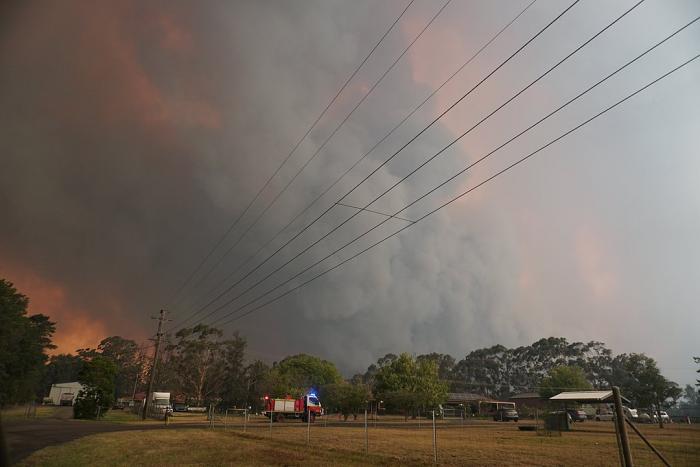
The 2020 fire season in California was the worst on record. However, these are not the most devastating fires in Earth’s recent past. Black Saturday Bushfires in February 2009 in Victoria, Australia were fueled by extraordinary heat and strong winds. At the peak of the inferno, there were some 400 blazes. Conditions leading up to the fires were extraordinary. Mercury hit 116 degrees in Melbourne in a heatwave that started the week before the fire, and in the peak of the summer drought, the dry brush was perfect fuel. On the fateful Saturday, the first fire was started by arson. Falling power lines and lightning ignited other fires. Fires consumed some 1.1 million acres, destroyed whole towns, caused some $4.4 billion in damage, and killed 173 people. Most of the damage was done in the first few days, but the blazes raged for weeks. One of the astounding aspects of the fires were observations by firefighters of sideways mini-tornadoes, technically called horizontal convective rolls. As the air at the surface warmed and rose, it was forced to move in a corkscrew pattern-oriented parallel to the ground. This created bands of alternating fast and slower surface winds. Fast winds surpassed 30 mph and ignited huge swaths of land in a catastrophic fire. There are terrifying stories of people getting swept up in the flames trying to escape the inferno on tiny mountain roads.
The late part of 2019 and the early stages of 2020 have brought more intense wildfire to Australia, especially near Sydney in the southeast. The season began very early as a result of the decade long drought and intense heatwaves (see Heatwave page this module). As of this reporting fires have burned millions of acres, destroyed thousands of buildings, and killed dozens of people and millions of animals including koala and kangaroos. The smoke has caused unhealthy air in eastern Australian cities and the plume has drifted as far as New Zealand. The fires have caused a political upheaval because Australia has a large emission of carbon per capita and produces a significant amount of energy from coal. Given how susceptible it is to climate change, many citizens feel that the country is not doing enough to curb emissions. 2019-2020 is a glimpse of the future for Australians.
Relationship between fire and climate change
So, how is increased fire activity related to climate change? Fire is very much a part of the ecosystem in places like Australia, California, South Africa, and Southern Europe. Even before people were around, fires ignited by lightning occur regularly in environments with dry seasons, as nature’s way of germinating drought-resistant species and fertilizing the soil. But people have made fire events much more common. First, many fires are started by arson or in the cases of the Lahaina and Camp fires by downed electric utility poles. Clearly, heat and drought are good for fire, and as we have seen, both of these ingredients will increase in the future as a result of anthropogenic climate change. But the other key aspect of fire is fuel and which is supplied by precipitation and active growth of vegetation. Climate change is likely to cause more variability in temperature and precipitation that will create more contrast between drought and wet years. This will lead to greater fire risk. The heavy rains in California in the winter of 2016-2017 caused a significant growth of vegetation in uncultivated hills and canyons surrounding residential areas and this dried out in the hot and dry 2017 summer. Then, once the warm fall Santa Ana winds arrived, the recipe for disaster was all ready.
The main culprit for the increase in fires in the western US and Hawaii is the long-term drought. However, development in forested and brushy areas that are prone to burn. Clearing of brush in populated areas has led to the establishment of invasive plant species that grow very rapidly and provide fuel when they die back in the dry season. There has been constant friction between responsible forest management with regulation and development. The potential for gigafires will force a reckoning between planning and forestry departments in the future so that forest and brush can be managed through controlled burns. Many communities are also replanting native plant species and using animals to clear out areas overwhelmed by invasives. At the same time, growth needs to be managed so that safe evacuation can occur in the case of a large fire. Sadly, highly destructive wildfires are part of California’s future.
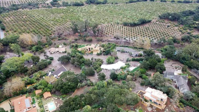
As are mudslides. The huge Thomas fire destroyed so much vegetation that held hill-slopes in place. They were followed in early January by major rains that led to torrents of mud from hills into valleys. The catastrophic mudslides killed at least 20 people and caused massive property damage. Fire and mud are intricately related.
One of the main messages from the 2022 IPCC report is the need to adapt to a future in which fire is more common and more deadly. In fact California is already making progress adapting its communities to live with the threat. In some areas, development is being banned in risky locations near forests for example, and best practices are being applied for clearing brush and maintaining fire breaks. Australia has been applying these best practices for a number of years also.
What is also clear from the IPCC report is that wildfires like drought will have a major impact on human health especially for children, the elderly and the poor. The impact will also be more severe in the developing world where fires set for the purpose of deforestation are having a major effect on human health as well as wiping out large numbers of species, a topic we will return to in Module 11.