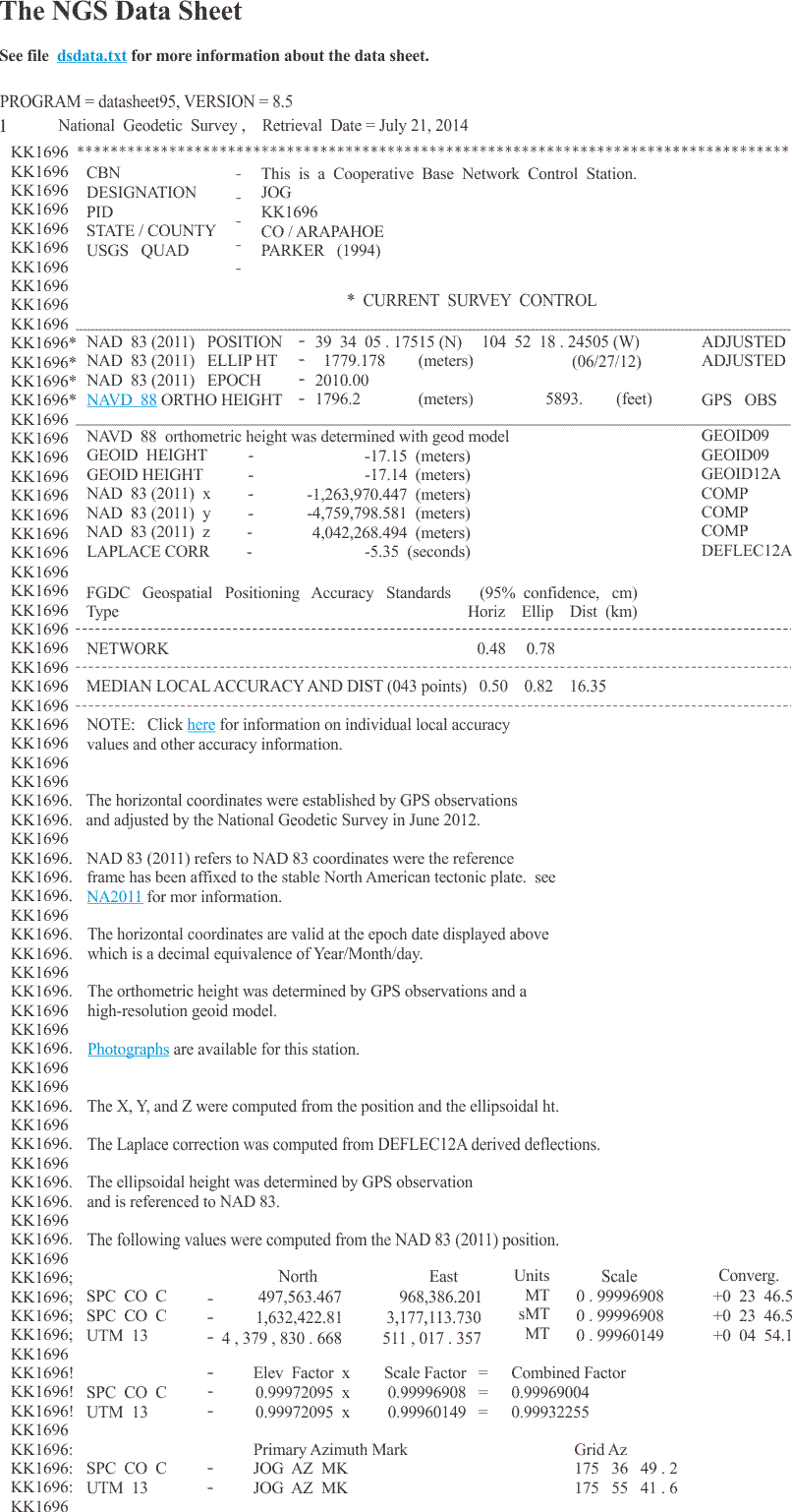
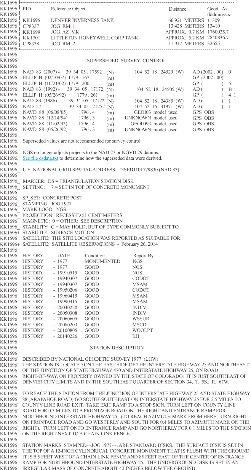
One of the things that is very useful is understanding the existing control that is currently available. Brass tablets and brass caps have been set around the United States by the National Geodetic Survey also known as passive marks. You can retrieve sheets that are similar to what you see in the illustration. These sheets have a great deal of excellent information concerning the coordinates, the quality, and many of the details about existing control points that can be used as checkpoints in any GPS/GNSS survey. Monuments that are the physical manifestation of the National Spatial Reference System (NSRS) and can be occupied with survey equipment are known as passive marks. They can provide reliable control when properly utilized. That utilization should be informed by an understanding of the datasheet that accompanies each station and is easily available online. There is a good deal of information about the passive survey monuments on each individual sheet. In addition to the latitude and longitude, the published data include the state plane coordinates in the appropriate zones. The first line of each data sheet includes the retrieval date. Then the station’s category is indicated. There are several, and among them are Continuously Operating Reference Station, Federal Base Network Control Station, and Cooperative Base Network Control Station. This is followed by the station’s designation, which is its name, and its Point Identification, PID. Either of these may be used to search for the station in the NGS database. The PID is also found all along the left side of each data sheet record and is always two upper case letters followed by four numbers. The state, county, country and U.S. Geological Survey (USGS)-7.5 minute quad name follows. Even though the station is located in the area covered by the quad sheet, it may not actually appear in the map. Under the heading, “Current Survey Control,” you will find the latitude and longitude of the station in NAD83 which is fixed to the North American plate, currently in NAD83 (2011), and its height in NAVD88. The orthometric height in meters is listed as “ORTHO HEIGHT” and followed by the same in feet. When the height is derived from GPS/GNSS observation, a geoid model must be used to determine the orthometric height. The model used is given. Adjustments to NAD27 and NGVD29 datums are a thing of the past. However, these old values may be shown under Superseded Survey Control. Horizontal values may be either Scaled, if the station is a benchmark or Adjusted, if the station is indeed a horizontal control point.
When a date is shown in parentheses after NAD83 in the data sheet, it means that the position has been readjusted. There are 13 sources of vertical control values shown on NGS data sheets. Here are a few of the categories. There is Adjusted, which are given to 3 decimal places and are derived from least squares adjustment of precise leveling. Another category is Posted, which indicates that the station was adjusted after the general NAVD adjustment in 1991. When a station’s elevation has been found by precise leveling but non-rigorous adjustment, it is called Computed. Stations’ vertical values are given to 1 decimal place if they are from GPS/GNSS observation (Obs) or vertical angle measurements (Vert Ang). And they have no decimal places if they were scaled from topographic map, Scaled, or found by conversion from NGVD29 values using the program known as VERTCON. The NGS Data Sheet.
When they are available, earth-centered earth-fixed (ECEF) coordinates are shown in X,Y and Z. These are right-handed system, 3-D Cartesian coordinates and are computed from the position and the ellipsoidal height. They are the same type of X, Y, and Z coordinates presented earlier. These values are followed by the quantity which, when added to an astronomic azimuth, yields a geodetic azimuth, is known as the Laplace correction. It is important to note that NGS uses a clockwise rotation regarding the Laplace correction. The ellipsoid height per the NAD83 ellipsoid is shown followed by the geoid height where the position is covered by NGS’s GEOID program. Photographs of the station may also be available in some cases. When the data sheet is retrieved online, one can use the link provided to bring them up. Also, the geoidal model used is noted. Of course, the first retrieval date at the top of the sheet is valuable to know when the point was last recovered. There's much detail here. I leave it to you to read. But suffice it to say for the objective here, the NGS data sheet is helpful to learn what control is available in a particular area.
Coordinates
NGS data sheets also provide State Plane and Universal Transverse Mercator (UTM) coordinates, the latter only for horizontal control stations. State Plane Coordinates are given in both U.S. Survey Feet or International Feet, and UTM coordinates are given in meters. Azimuths to the primary azimuth mark are clockwise from north and scale factors for conversion from ellipsoidal distances to grid distances. This information may be followed by distances to reference objects. Coordinates are not given for azimuth marks or reference objects on the data sheet.
The Station Mark
Along with mark setting information, the type of monument and the history of mark recovery, the NGS data sheets provide a valuable to-reach description. It begins with the general location of the station. Then starting at a well-known location, the route is described with right and left turns, directions, road names, and the distance traveled along each leg in kilometers. When the mark is reached, the monument is described, and horizontal and vertical ties are shown. Finally, there may be notes about obstructions to GPS/GNSS visibility, and so forth.
Significance of the Information
The value of the description of the monument’s location and the route used to reach it is directly proportional to the date it was prepared and the remoteness of its location. The conditions around older stations often change dramatically when the area has become accessible to the public. If the age and location of a station increases the probability that it has been disturbed or destroyed, then reference monuments can be noted as alternatives worthy of on-site investigation. However, special care ought to be taken to ensure that the reference monuments are not confused with the station marks themselves.
The role of passive marks is undergoing a change as a new North American reference frame takes shape (North American Terrestrial Reference Frame: NATRF). NGS is no longer setting nor maintaining passive marks.