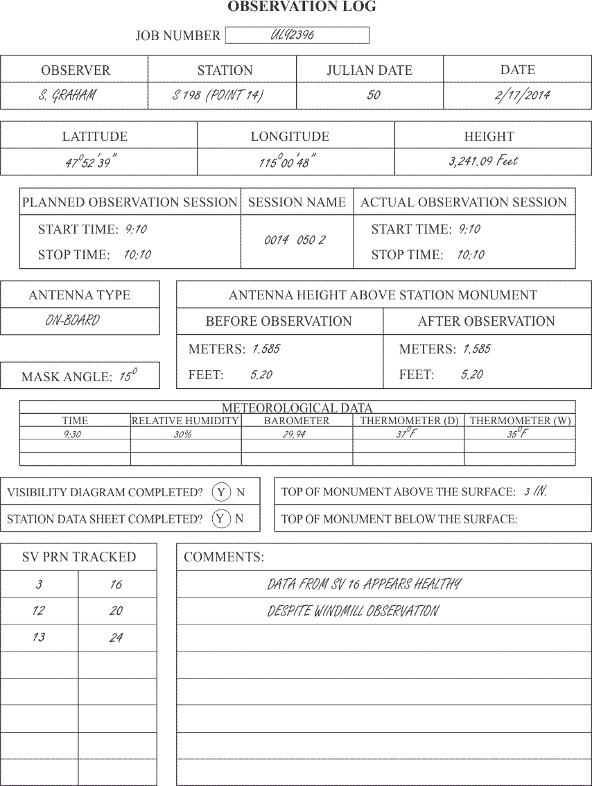
The most immediate use of the observation log is an evaluation of the day's work. Most GPS/GNSS control survey operations require its receiver operators to keep a careful log of each observation. Usually written on a standard form, these field notes provide a written record of the measurements, times, equipment, and other data that explains what actually occurred during the observation itself. It is difficult to overestimate the importance of this information. It is usually incorporated into the final report of the survey, the archives, and any subsequent effort to blue-book the project. However, the most immediate use of the observation log is in evaluation of the day's work by the on-site field supervisor. An observation log may be organized in a number of ways. The log illustrated is one method that includes some of the information that might be used to document one session at one station. Of course, the name of the observer and the station must be included, and while the date need not be expressed in both the Julian and Gregorian calendars, that information may help in quick cataloging of the data. The approximate latitude, longitude, and height of the station are usually required by the receiver as a reference position for its search for satellites. The date of the planned session will not necessarily coincide with the actual session observed. The observer's arrival at the point may have been late, or the receiver may have been allowed to collect data beyond the scheduled end of the session. There are various methods used to name the observation session in terminology that is sensible to computers. A widely used system is noted here. The first four digits are the project point’s number. In this case, it is point 14 and is designated 0014. The next three digits are the Julian day of the session, in this case it is day 50, or 050. Finally, the session illustrated is the second of the day, or 2. Therefore, the full session name is 0014 050 2. Whether onboard or separate, the type of the antenna used and the height of the antenna are critical pieces of information. The relation of the height of the station to the height of the antenna is vital to the station’s later utility. The distance that the top of the station's monument is found above or below the surface of the surrounding soil is sometimes neglected. This information can not only be useful in later recovery of the monument, but can also be important in the proper evaluation of photo-control panel points.
Weather
The meteorological data is useful in modeling the atmospheric delay. Measurement of the atmospheric pressure in millibars, the relative humidity, and the temperature in degrees Centigrade are sometimes expected to be in the observation log. However, the general use is less stringent. The conditions of the day are observed, and unusual changes in the weather are noted. A record of the satellites that are actually available during the observation and any comments about unique circumstances of the session round out the observation log.